Peoples of the Arctic - Published 1983 by National Geographic
Indigenous Cultures, Historic Boundaries & Polar Landscapes | Thematic Wall Map | 748 × 577 mm | Premium Finishes
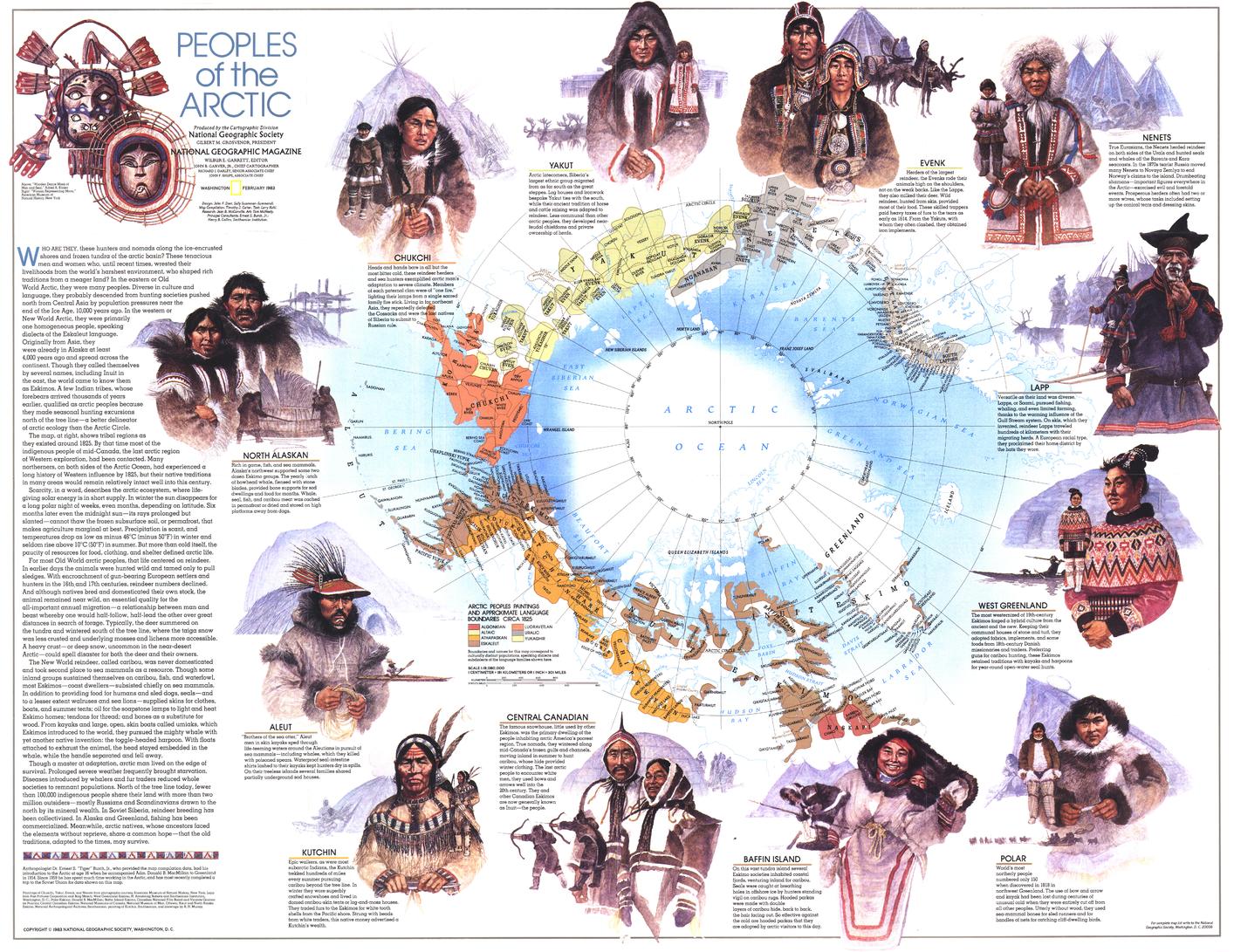
A compelling exploration of life at the edge of the world, Peoples of the Arctic reveals the cultures, traditions, and historic territories of those who have long called the far north home. Published by National Geographic in February 1983, this map blends anthropology, geography, and history across the vast expanse of the Arctic.
Issued alongside the Arctic Ocean map and a series of articles including “Hunters of the Lost Spirit,” it offers a rare insight into human life in one of Earth’s most extreme environments.
Why This Map Stands Out
A map of Arctic cultures
Highlights the diversity of Indigenous peoples across the polar north.
Historic perspective (circa 1825)
Shows approximate territorial boundaries of Arctic inhabitants.
Rich anthropological detail
Combines cultural, geographic, and historical information.
Part of a broader Arctic series
Designed to complement ocean and exploration maps of the region.
A visually striking educational piece
Balances clarity, narrative, and design.
🗺️ What the Map Shows
🧑🤝🧑 Peoples & Territories
- Distribution of Indigenous Arctic groups across the region
- Approximate cultural boundaries circa 1825
- A framework showing how communities adapted to specific environments
🌍 Arctic Region Coverage
- The circumpolar north, including areas within:
- Alaska
- Canada
- Greenland
- Russia
- Scandinavia
- Coastlines, sea ice zones, and landforms shaping settlement
🎨 Illustrations & Cultural Insight
- Visual elements depicting traditional life and survival
- Notes on hunting, migration, and adaptation
- A blend of education and storytelling
❄️ Life in the Far North
The Arctic demands resilience:
- Extreme cold and seasonal darkness
- Reliance on hunting, fishing, and migration
- Deep cultural knowledge passed through generations
- Close relationships between people and environment
This map captures that reality—showing how human life has adapted to one of the planet’s most demanding regions.
📐 Size & Format
748 mm (W) × 577 mm (H)
Landscape orientation
A balanced size ideal for:
- Classrooms and cultural studies
- Universities and research environments
- Offices and educational spaces
- Home libraries and thoughtful interiors
✨ Premium Finishes & Display Options
Every Peoples of the Arctic (1983) map is produced using archival-grade materials and precision colour management, ensuring clarity across text, illustration, and thematic detail.
📜 Heavyweight Paper (160 gsm Matte)
Classic. Refined. Frame-ready.
- Premium 160 gsm matte-coated archival paper
- Smooth, low-glare surface for readability
- Ideal for framing under glass
💡 Best for: educational settings and traditional display.
🧼 Laminated (True Encapsulation — 2 × 80 Micron Gloss)
Durable. Practical. Built to last.
- Fully sealed with 2 × 80-micron laminate
- Edge-to-edge protection against wear and moisture
- Wipe-clean surface for annotation
💡 Best for: classrooms and interactive environments.
🪵 Laminated + Timber Hang Rails
Ready to hang. Clean lines. Contemporary feel.
- Natural timber rails (top & bottom), lacquered finish
- Includes hanging cord for immediate display
- Keeps map flat without framing
🔨 Please allow up to 10 working days.
💡 Best for: modern, ready-to-hang display.
🖼️ Archival Canvas (395 gsm HP Professional Matte)
Textured. Elegant. Gallery-quality.
- Printed on 395 gsm HP Professional Matte Canvas
- Pigment-based inks for long-term colour stability
- Subtle texture enhances visual depth
💡 Best for: feature walls and premium interiors.
🪵 Canvas + Timber Hang Rails
Gallery-ready. Warm. Architectural.
- Canvas paired with natural timber rails
- Clean, balanced presentation
🔨 Please allow up to 10 working days.
💡 Best for: statement display spaces.
📊 Specifications
| Feature | Detail |
|---|---|
| Title | Peoples of the Arctic |
| Publisher | National Geographic |
| Published | 1983 |
| Scale | 1:19,080,000 |
| Dimensions | 748 mm × 577 mm |
| Orientation | Landscape |
| Map Type | Thematic |
| Coverage | Arctic Region |
| Collections | Poles, Historical, Thematic |
| Materials | 160 gsm matte paper · 2 × 80-micron laminate · 395 gsm HP Professional Matte Canvas |
| Inks | Pigment-based, fade-resistant |
| Origin | Printed in Australia |
🎯 Ideal For
- Students and educators of geography, anthropology, and polar studies
- Researchers exploring Indigenous cultures and Arctic history
- Collectors of National Geographic thematic maps
- Interiors seeking a thoughtful, educational display piece
- Gift buyers looking for a map with cultural and historical depth
🌍 A Human Story at the Edge of the World
The Arctic is often seen as remote—but it is deeply human:
- A region of enduring cultures and traditions
- A landscape that shapes identity and survival
- A place where history is written in ice, land, and memory
This map brings that story into focus—offering a clear and compelling view of the peoples who have thrived in the Arctic for generations.
🤝 Our Commitment
- Printed in Australia using archival-quality materials
- Faithfully reproduced to preserve clarity and detail
- Premium finishes designed for long-term display
- Each map is hand-checked and carefully packed
🚚 Delivery
- Rolled (Paper, Laminated, Canvas): Dispatch within 1–2 business days
- Hang-Railed Finishes: Made to order — allow up to 10 working days
Discover life at the top of the world—
a map that brings the peoples of the Arctic into clear, human focus.
Original: $50.05
-65%$50.05
$17.52Product Information
Product Information
Shipping & Returns
Shipping & Returns
Description
Indigenous Cultures, Historic Boundaries & Polar Landscapes | Thematic Wall Map | 748 × 577 mm | Premium Finishes
A compelling exploration of life at the edge of the world, Peoples of the Arctic reveals the cultures, traditions, and historic territories of those who have long called the far north home. Published by National Geographic in February 1983, this map blends anthropology, geography, and history across the vast expanse of the Arctic.
Issued alongside the Arctic Ocean map and a series of articles including “Hunters of the Lost Spirit,” it offers a rare insight into human life in one of Earth’s most extreme environments.
Why This Map Stands Out
A map of Arctic cultures
Highlights the diversity of Indigenous peoples across the polar north.
Historic perspective (circa 1825)
Shows approximate territorial boundaries of Arctic inhabitants.
Rich anthropological detail
Combines cultural, geographic, and historical information.
Part of a broader Arctic series
Designed to complement ocean and exploration maps of the region.
A visually striking educational piece
Balances clarity, narrative, and design.
🗺️ What the Map Shows
🧑🤝🧑 Peoples & Territories
- Distribution of Indigenous Arctic groups across the region
- Approximate cultural boundaries circa 1825
- A framework showing how communities adapted to specific environments
🌍 Arctic Region Coverage
- The circumpolar north, including areas within:
- Alaska
- Canada
- Greenland
- Russia
- Scandinavia
- Coastlines, sea ice zones, and landforms shaping settlement
🎨 Illustrations & Cultural Insight
- Visual elements depicting traditional life and survival
- Notes on hunting, migration, and adaptation
- A blend of education and storytelling
❄️ Life in the Far North
The Arctic demands resilience:
- Extreme cold and seasonal darkness
- Reliance on hunting, fishing, and migration
- Deep cultural knowledge passed through generations
- Close relationships between people and environment
This map captures that reality—showing how human life has adapted to one of the planet’s most demanding regions.
📐 Size & Format
748 mm (W) × 577 mm (H)
Landscape orientation
A balanced size ideal for:
- Classrooms and cultural studies
- Universities and research environments
- Offices and educational spaces
- Home libraries and thoughtful interiors
✨ Premium Finishes & Display Options
Every Peoples of the Arctic (1983) map is produced using archival-grade materials and precision colour management, ensuring clarity across text, illustration, and thematic detail.
📜 Heavyweight Paper (160 gsm Matte)
Classic. Refined. Frame-ready.
- Premium 160 gsm matte-coated archival paper
- Smooth, low-glare surface for readability
- Ideal for framing under glass
💡 Best for: educational settings and traditional display.
🧼 Laminated (True Encapsulation — 2 × 80 Micron Gloss)
Durable. Practical. Built to last.
- Fully sealed with 2 × 80-micron laminate
- Edge-to-edge protection against wear and moisture
- Wipe-clean surface for annotation
💡 Best for: classrooms and interactive environments.
🪵 Laminated + Timber Hang Rails
Ready to hang. Clean lines. Contemporary feel.
- Natural timber rails (top & bottom), lacquered finish
- Includes hanging cord for immediate display
- Keeps map flat without framing
🔨 Please allow up to 10 working days.
💡 Best for: modern, ready-to-hang display.
🖼️ Archival Canvas (395 gsm HP Professional Matte)
Textured. Elegant. Gallery-quality.
- Printed on 395 gsm HP Professional Matte Canvas
- Pigment-based inks for long-term colour stability
- Subtle texture enhances visual depth
💡 Best for: feature walls and premium interiors.
🪵 Canvas + Timber Hang Rails
Gallery-ready. Warm. Architectural.
- Canvas paired with natural timber rails
- Clean, balanced presentation
🔨 Please allow up to 10 working days.
💡 Best for: statement display spaces.
📊 Specifications
| Feature | Detail |
|---|---|
| Title | Peoples of the Arctic |
| Publisher | National Geographic |
| Published | 1983 |
| Scale | 1:19,080,000 |
| Dimensions | 748 mm × 577 mm |
| Orientation | Landscape |
| Map Type | Thematic |
| Coverage | Arctic Region |
| Collections | Poles, Historical, Thematic |
| Materials | 160 gsm matte paper · 2 × 80-micron laminate · 395 gsm HP Professional Matte Canvas |
| Inks | Pigment-based, fade-resistant |
| Origin | Printed in Australia |
🎯 Ideal For
- Students and educators of geography, anthropology, and polar studies
- Researchers exploring Indigenous cultures and Arctic history
- Collectors of National Geographic thematic maps
- Interiors seeking a thoughtful, educational display piece
- Gift buyers looking for a map with cultural and historical depth
🌍 A Human Story at the Edge of the World
The Arctic is often seen as remote—but it is deeply human:
- A region of enduring cultures and traditions
- A landscape that shapes identity and survival
- A place where history is written in ice, land, and memory
This map brings that story into focus—offering a clear and compelling view of the peoples who have thrived in the Arctic for generations.
🤝 Our Commitment
- Printed in Australia using archival-quality materials
- Faithfully reproduced to preserve clarity and detail
- Premium finishes designed for long-term display
- Each map is hand-checked and carefully packed
🚚 Delivery
- Rolled (Paper, Laminated, Canvas): Dispatch within 1–2 business days
- Hang-Railed Finishes: Made to order — allow up to 10 working days
Discover life at the top of the world—
a map that brings the peoples of the Arctic into clear, human focus.


