Peoples of the Middle East - Published 1972 by National Geographic
Cultures, Religions & Landscapes in Relief | Thematic & Physical Wall Map | 903 × 573 mm | Premium Finishes
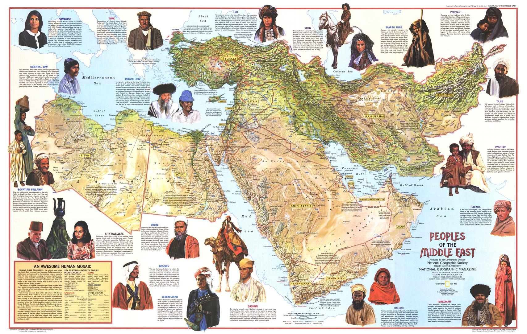
A richly layered portrait of a region where geography and civilisation are deeply intertwined, Peoples of the Middle East brings together terrain, culture, and history in one striking composition. Published by National Geographic in July 1972, this map combines detailed relief mapping with anthropological insight across the Middle East.
It’s a map that goes beyond borders—revealing the people, traditions, and environments that define one of the world’s most historically significant regions.
Why This Map Stands Out
Relief and culture combined
Blends physical geography with human diversity.
Rich anthropological detail
Explores religions, languages, and lifestyles across the region.
Illustrated storytelling
Enhanced with artwork and informative notes.
A broad regional perspective
Spans parts of Asia, North Africa, and the eastern Mediterranean.
A distinctive historical piece
Reflects understanding and scholarship of the early 1970s.
🗺️ What the Map Shows
🌍 Physical Landscape in Relief
- Mountain ranges, deserts, and river systems shaping the region
- Elevation and terrain influencing settlement and trade
- A clear sense of how geography defines movement and culture
🧑🤝🧑 Peoples, Languages & Traditions
- Distribution of ethnic and cultural groups
- Major language families across the region
- A framework linking identity to geography
🕊️ Religions & Cultural Heritage
- Key religious landscapes, including:
- Islam
- Christianity
- Judaism
- Cultural traditions shaped by centuries of history
🎨 Illustrations & Insight
- Visual depictions of traditional life and occupations
- Notes on trade, livelihoods, and regional customs
- A blend of education and visual narrative
🌐 A Crossroads of Civilisation
The Middle East has long been:
- A meeting point of continents—Asia, Africa, and Europe
- A cradle of major world religions
- A region shaped by trade routes and migration
- A landscape where environment and culture are inseparable
This map captures that complexity—offering a clear and compelling view of a region where history, belief, and geography converge.
📐 Size & Format
903 mm (W) × 573 mm (H)
Landscape orientation (large format)
A strong, wall-ready size ideal for:
- Classrooms and cultural studies
- Universities and research environments
- Offices and educational spaces
- Home libraries and curated interiors
✨ Premium Finishes & Display Options
Every Peoples of the Middle East (1972) map is produced using archival-grade materials and precision colour management, ensuring clarity across relief detail, text, and illustration.
📜 Heavyweight Paper (160 gsm Matte)
Classic. Refined. Frame-ready.
- Premium 160 gsm matte-coated archival paper
- Smooth, low-glare surface enhances readability and relief shading
- Ideal for framing under glass
💡 Best for: traditional display and detailed study.
🧼 Laminated (True Encapsulation — 2 × 80 Micron Gloss)
Durable. Practical. Built to last.
- Fully sealed with 2 × 80-micron laminate
- Edge-to-edge protection against wear and moisture
- Wipe-clean surface for annotation
💡 Best for: classrooms and interactive environments.
🪵 Laminated + Timber Hang Rails
Ready to hang. Clean lines. Contemporary feel.
- Natural timber rails (top & bottom), lacquered finish
- Includes hanging cord for immediate display
- Keeps map flat without framing
🔨 Please allow up to 10 working days.
💡 Best for: modern, ready-to-hang presentation.
🖼️ Archival Canvas (395 gsm HP Professional Matte)
Textured. Elegant. Gallery-quality.
- Printed on 395 gsm HP Professional Matte Canvas
- Pigment-based inks for long-term colour stability
- Subtle texture enhances terrain and depth
💡 Best for: feature walls and premium interiors.
🪵 Canvas + Timber Hang Rails
Gallery-ready. Warm. Architectural.
- Canvas paired with natural timber rails
- Clean, balanced presentation
🔨 Please allow up to 10 working days.
💡 Best for: statement display spaces.
📊 Specifications
| Feature | Detail |
|---|---|
| Title | Peoples of the Middle East |
| Publisher | National Geographic |
| Published | 1972 |
| Scale | 1:7,096,000 |
| Dimensions | 903 mm × 573 mm |
| Orientation | Landscape |
| Map Type | Physical / Thematic |
| Coverage | Middle East, parts of Africa & Asia |
| Collections | Middle East, Africa, Asia, Historical, Physical, Thematic |
| Materials | 160 gsm matte paper · 2 × 80-micron laminate · 395 gsm HP Professional Matte Canvas |
| Inks | Pigment-based, fade-resistant |
| Origin | Printed in Australia |
🎯 Ideal For
- Students and educators of geography, religion, and cultural studies
- Researchers exploring Middle Eastern history and societies
- Collectors of National Geographic thematic maps
- Interiors seeking a rich, narrative-driven display piece
- Gift buyers looking for a map with cultural and historical depth
🌍 A Region of Depth and Complexity
This map reveals a region defined by:
- Diverse peoples and traditions
- Landscapes shaping human settlement
- Religions influencing culture and identity
- A history layered across thousands of years
It’s a map that invites deeper understanding—offering a clear and compelling view of the peoples who define the Middle East.
🤝 Our Commitment
- Printed in Australia using archival-quality materials
- Faithfully reproduced to preserve colour, clarity, and relief detail
- Premium finishes designed for long-term display
- Each map is hand-checked and carefully packed
🚚 Delivery
- Rolled (Paper, Laminated, Canvas): Dispatch within 1–2 business days
- Hang-Railed Finishes: Made to order — allow up to 10 working days
Explore a crossroads of culture and landscape—
a map that brings the peoples of the Middle East into sharp, human focus.
Original: $50.05
-65%$50.05
$17.52Product Information
Product Information
Shipping & Returns
Shipping & Returns
Description
Cultures, Religions & Landscapes in Relief | Thematic & Physical Wall Map | 903 × 573 mm | Premium Finishes
A richly layered portrait of a region where geography and civilisation are deeply intertwined, Peoples of the Middle East brings together terrain, culture, and history in one striking composition. Published by National Geographic in July 1972, this map combines detailed relief mapping with anthropological insight across the Middle East.
It’s a map that goes beyond borders—revealing the people, traditions, and environments that define one of the world’s most historically significant regions.
Why This Map Stands Out
Relief and culture combined
Blends physical geography with human diversity.
Rich anthropological detail
Explores religions, languages, and lifestyles across the region.
Illustrated storytelling
Enhanced with artwork and informative notes.
A broad regional perspective
Spans parts of Asia, North Africa, and the eastern Mediterranean.
A distinctive historical piece
Reflects understanding and scholarship of the early 1970s.
🗺️ What the Map Shows
🌍 Physical Landscape in Relief
- Mountain ranges, deserts, and river systems shaping the region
- Elevation and terrain influencing settlement and trade
- A clear sense of how geography defines movement and culture
🧑🤝🧑 Peoples, Languages & Traditions
- Distribution of ethnic and cultural groups
- Major language families across the region
- A framework linking identity to geography
🕊️ Religions & Cultural Heritage
- Key religious landscapes, including:
- Islam
- Christianity
- Judaism
- Cultural traditions shaped by centuries of history
🎨 Illustrations & Insight
- Visual depictions of traditional life and occupations
- Notes on trade, livelihoods, and regional customs
- A blend of education and visual narrative
🌐 A Crossroads of Civilisation
The Middle East has long been:
- A meeting point of continents—Asia, Africa, and Europe
- A cradle of major world religions
- A region shaped by trade routes and migration
- A landscape where environment and culture are inseparable
This map captures that complexity—offering a clear and compelling view of a region where history, belief, and geography converge.
📐 Size & Format
903 mm (W) × 573 mm (H)
Landscape orientation (large format)
A strong, wall-ready size ideal for:
- Classrooms and cultural studies
- Universities and research environments
- Offices and educational spaces
- Home libraries and curated interiors
✨ Premium Finishes & Display Options
Every Peoples of the Middle East (1972) map is produced using archival-grade materials and precision colour management, ensuring clarity across relief detail, text, and illustration.
📜 Heavyweight Paper (160 gsm Matte)
Classic. Refined. Frame-ready.
- Premium 160 gsm matte-coated archival paper
- Smooth, low-glare surface enhances readability and relief shading
- Ideal for framing under glass
💡 Best for: traditional display and detailed study.
🧼 Laminated (True Encapsulation — 2 × 80 Micron Gloss)
Durable. Practical. Built to last.
- Fully sealed with 2 × 80-micron laminate
- Edge-to-edge protection against wear and moisture
- Wipe-clean surface for annotation
💡 Best for: classrooms and interactive environments.
🪵 Laminated + Timber Hang Rails
Ready to hang. Clean lines. Contemporary feel.
- Natural timber rails (top & bottom), lacquered finish
- Includes hanging cord for immediate display
- Keeps map flat without framing
🔨 Please allow up to 10 working days.
💡 Best for: modern, ready-to-hang presentation.
🖼️ Archival Canvas (395 gsm HP Professional Matte)
Textured. Elegant. Gallery-quality.
- Printed on 395 gsm HP Professional Matte Canvas
- Pigment-based inks for long-term colour stability
- Subtle texture enhances terrain and depth
💡 Best for: feature walls and premium interiors.
🪵 Canvas + Timber Hang Rails
Gallery-ready. Warm. Architectural.
- Canvas paired with natural timber rails
- Clean, balanced presentation
🔨 Please allow up to 10 working days.
💡 Best for: statement display spaces.
📊 Specifications
| Feature | Detail |
|---|---|
| Title | Peoples of the Middle East |
| Publisher | National Geographic |
| Published | 1972 |
| Scale | 1:7,096,000 |
| Dimensions | 903 mm × 573 mm |
| Orientation | Landscape |
| Map Type | Physical / Thematic |
| Coverage | Middle East, parts of Africa & Asia |
| Collections | Middle East, Africa, Asia, Historical, Physical, Thematic |
| Materials | 160 gsm matte paper · 2 × 80-micron laminate · 395 gsm HP Professional Matte Canvas |
| Inks | Pigment-based, fade-resistant |
| Origin | Printed in Australia |
🎯 Ideal For
- Students and educators of geography, religion, and cultural studies
- Researchers exploring Middle Eastern history and societies
- Collectors of National Geographic thematic maps
- Interiors seeking a rich, narrative-driven display piece
- Gift buyers looking for a map with cultural and historical depth
🌍 A Region of Depth and Complexity
This map reveals a region defined by:
- Diverse peoples and traditions
- Landscapes shaping human settlement
- Religions influencing culture and identity
- A history layered across thousands of years
It’s a map that invites deeper understanding—offering a clear and compelling view of the peoples who define the Middle East.
🤝 Our Commitment
- Printed in Australia using archival-quality materials
- Faithfully reproduced to preserve colour, clarity, and relief detail
- Premium finishes designed for long-term display
- Each map is hand-checked and carefully packed
🚚 Delivery
- Rolled (Paper, Laminated, Canvas): Dispatch within 1–2 business days
- Hang-Railed Finishes: Made to order — allow up to 10 working days
Explore a crossroads of culture and landscape—
a map that brings the peoples of the Middle East into sharp, human focus.


