Peoples of the Middle East Theme - Published 1972 by National Geographic
Historical Layers, Religion, Society & Land Use | Thematic Wall Map | 903 × 573 mm | Premium Finishes
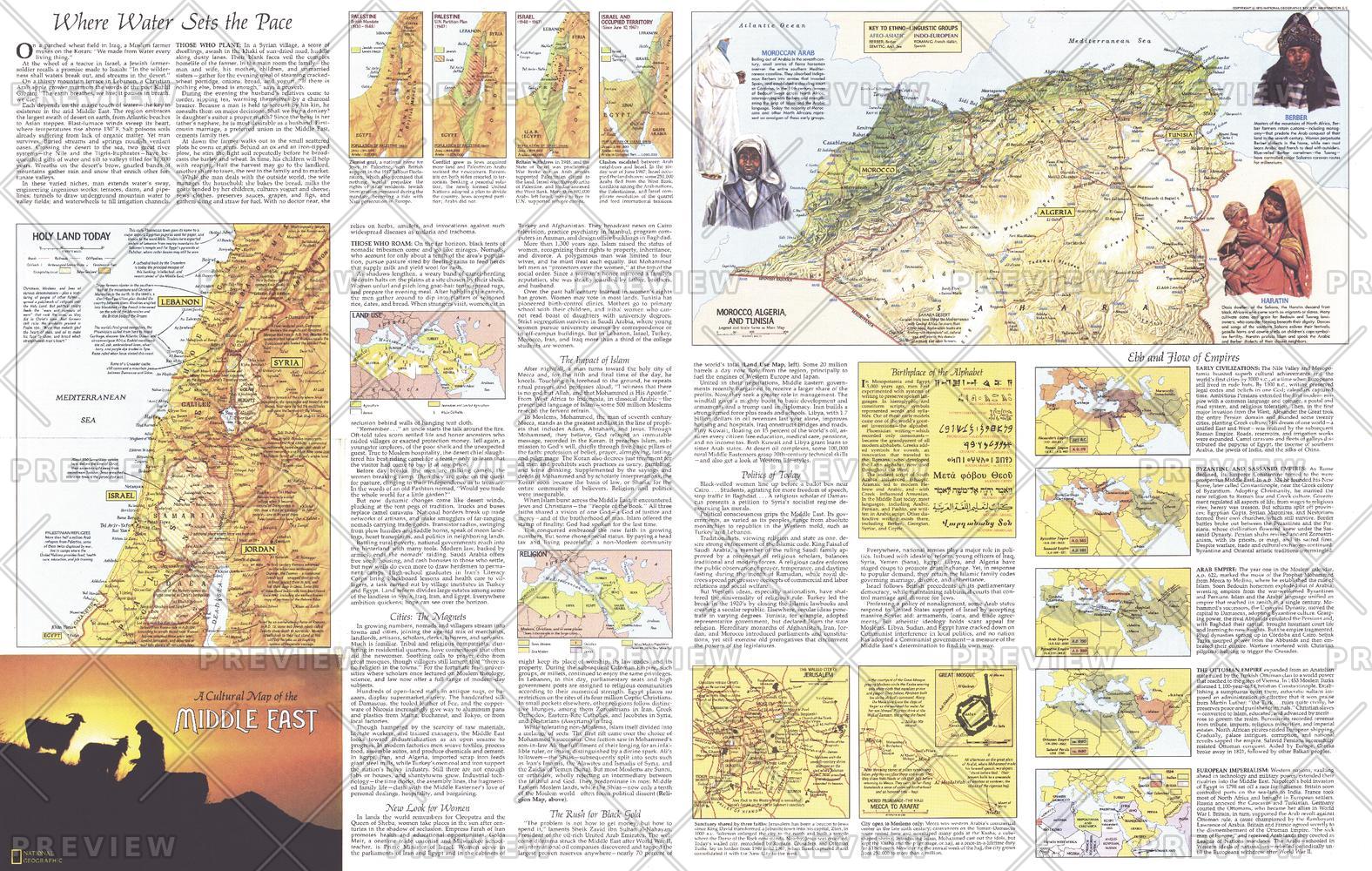
A deeper, analytical companion to the primary map, Peoples of the Middle East — Theme expands the story of the region through a series of richly detailed thematic panels. Published by National Geographic in July 1972, this map forms half of a two-map set, offering a multi-layered exploration of the Middle East and its peoples.
Through more than a dozen inset maps and visual studies, it examines history, religion, land use, and social structure—providing context that goes far beyond geography alone.
Why This Map Stands Out
A multi-layered perspective
Uses thematic maps to explore the region across time and society.
Beyond geography
Covers religion, politics, livelihoods, and social roles.
Rich visual storytelling
Combines maps, diagrams, and explanatory notes.
Designed as a companion piece
Completes the narrative of the Peoples of the Middle East map.
A rare historical reference
Captures regional understanding as presented in the early 1970s.
🗺️ What the Map Shows
🧭 A Series of Thematic Insets
- Over a dozen detailed maps exploring:
- Historical periods and shifting boundaries
- Distribution of ethnic groups
- Religious centres and sacred sites
- Patterns of land use and agriculture
🕊️ Religion & Society
- The geographic spread of major religions
- Cultural influence of belief systems across the region
- Insights into social organisation and identity
👩 Social Structure & Daily Life
- Notes on livelihoods, trade, and economic activity
- Discussion of social roles, including the role of women
- A broader understanding of how communities function
🌍 Politics & Change
- Regional dynamics and political context of the time
- A snapshot of a region in transition during the late 20th century
🌐 A Region in Layers
The Middle East cannot be understood through a single lens:
- History shapes borders and identities
- Religion influences culture and daily life
- Land use reflects environment and tradition
- Society evolves alongside political change
This map brings those layers together—offering a comprehensive, structured view of a complex region.
📐 Size & Format
903 mm (W) × 573 mm (H)
Landscape orientation (large format)
Ideal for:
- Classrooms and higher education
- Research and policy environments
- Offices and analytical spaces
- Pairing with the companion map for a complete set
✨ Premium Finishes & Display Options
Every Peoples of the Middle East — Theme (1972) map is produced using archival-grade materials and precision colour management, ensuring clarity across fine text, inset maps, and thematic detail.
📜 Heavyweight Paper (160 gsm Matte)
Classic. Refined. Frame-ready.
- Premium 160 gsm matte-coated archival paper
- Smooth, low-glare surface for readability of dense information
- Ideal for framing under glass
💡 Best for: study, reference, and traditional display.
🧼 Laminated (True Encapsulation — 2 × 80 Micron Gloss)
Durable. Practical. Built to last.
- Fully sealed with 2 × 80-micron laminate
- Edge-to-edge protection against wear and handling
- Wipe-clean surface for notes and annotation
💡 Best for: classrooms and working environments.
🪵 Laminated + Timber Hang Rails
Ready to hang. Clean lines. Contemporary feel.
- Natural timber rails (top & bottom), lacquered finish
- Includes hanging cord for immediate display
- Keeps map flat and structured
🔨 Please allow up to 10 working days.
💡 Best for: offices and ready-to-hang analytical displays.
🖼️ Archival Canvas (395 gsm HP Professional Matte)
Textured. Elegant. Gallery-quality.
- Printed on 395 gsm HP Professional Matte Canvas
- Pigment-based inks ensure long-term colour stability
- Subtle texture enhances visual depth
💡 Best for: feature walls with a refined, intellectual aesthetic.
🪵 Canvas + Timber Hang Rails
Gallery-ready. Warm. Architectural.
- Canvas paired with natural timber rails
- Clean, balanced presentation
🔨 Please allow up to 10 working days.
💡 Best for: statement spaces and curated interiors.
📊 Specifications
| Feature | Detail |
|---|---|
| Title | Peoples of the Middle East — Theme |
| Publisher | National Geographic |
| Published | 1972 |
| Dimensions | 903 mm × 573 mm |
| Orientation | Landscape |
| Map Type | Thematic |
| Coverage | Middle East |
| Collections | Africa, Asia, Historical |
| Materials | 160 gsm matte paper · 2 × 80-micron laminate · 395 gsm HP Professional Matte Canvas |
| Inks | Pigment-based, fade-resistant |
| Origin | Printed in Australia |
🎯 Ideal For
- Students and educators of history, politics, and cultural studies
- Researchers exploring Middle Eastern society and development
- Collectors completing the two-map Middle East set
- Interiors seeking a thoughtful, information-rich display
- Gift buyers looking for a map with depth and analytical value
🧭 Understanding the Region Beyond the Surface
This map reveals:
- The forces shaping societies across time
- The interplay between religion, land, and identity
- The complexity behind modern political landscapes
- A region defined by layers—not simplicity
It’s a map that answers not just where, but why the Middle East is the way it is today.
🤝 Our Commitment
- Printed in Australia using archival-quality materials
- Faithfully reproduced to preserve clarity and fine detail
- Premium finishes designed for long-term display
- Each map is hand-checked and carefully packed
🚚 Delivery
- Rolled (Paper, Laminated, Canvas): Dispatch within 1–2 business days
- Hang-Railed Finishes: Made to order — allow up to 10 working days
See the region in layers—
a map that brings the Middle East’s history, society, and structure into sharp focus.
Original: $50.05
-65%$50.05
$17.52Product Information
Product Information
Shipping & Returns
Shipping & Returns
Description
Historical Layers, Religion, Society & Land Use | Thematic Wall Map | 903 × 573 mm | Premium Finishes
A deeper, analytical companion to the primary map, Peoples of the Middle East — Theme expands the story of the region through a series of richly detailed thematic panels. Published by National Geographic in July 1972, this map forms half of a two-map set, offering a multi-layered exploration of the Middle East and its peoples.
Through more than a dozen inset maps and visual studies, it examines history, religion, land use, and social structure—providing context that goes far beyond geography alone.
Why This Map Stands Out
A multi-layered perspective
Uses thematic maps to explore the region across time and society.
Beyond geography
Covers religion, politics, livelihoods, and social roles.
Rich visual storytelling
Combines maps, diagrams, and explanatory notes.
Designed as a companion piece
Completes the narrative of the Peoples of the Middle East map.
A rare historical reference
Captures regional understanding as presented in the early 1970s.
🗺️ What the Map Shows
🧭 A Series of Thematic Insets
- Over a dozen detailed maps exploring:
- Historical periods and shifting boundaries
- Distribution of ethnic groups
- Religious centres and sacred sites
- Patterns of land use and agriculture
🕊️ Religion & Society
- The geographic spread of major religions
- Cultural influence of belief systems across the region
- Insights into social organisation and identity
👩 Social Structure & Daily Life
- Notes on livelihoods, trade, and economic activity
- Discussion of social roles, including the role of women
- A broader understanding of how communities function
🌍 Politics & Change
- Regional dynamics and political context of the time
- A snapshot of a region in transition during the late 20th century
🌐 A Region in Layers
The Middle East cannot be understood through a single lens:
- History shapes borders and identities
- Religion influences culture and daily life
- Land use reflects environment and tradition
- Society evolves alongside political change
This map brings those layers together—offering a comprehensive, structured view of a complex region.
📐 Size & Format
903 mm (W) × 573 mm (H)
Landscape orientation (large format)
Ideal for:
- Classrooms and higher education
- Research and policy environments
- Offices and analytical spaces
- Pairing with the companion map for a complete set
✨ Premium Finishes & Display Options
Every Peoples of the Middle East — Theme (1972) map is produced using archival-grade materials and precision colour management, ensuring clarity across fine text, inset maps, and thematic detail.
📜 Heavyweight Paper (160 gsm Matte)
Classic. Refined. Frame-ready.
- Premium 160 gsm matte-coated archival paper
- Smooth, low-glare surface for readability of dense information
- Ideal for framing under glass
💡 Best for: study, reference, and traditional display.
🧼 Laminated (True Encapsulation — 2 × 80 Micron Gloss)
Durable. Practical. Built to last.
- Fully sealed with 2 × 80-micron laminate
- Edge-to-edge protection against wear and handling
- Wipe-clean surface for notes and annotation
💡 Best for: classrooms and working environments.
🪵 Laminated + Timber Hang Rails
Ready to hang. Clean lines. Contemporary feel.
- Natural timber rails (top & bottom), lacquered finish
- Includes hanging cord for immediate display
- Keeps map flat and structured
🔨 Please allow up to 10 working days.
💡 Best for: offices and ready-to-hang analytical displays.
🖼️ Archival Canvas (395 gsm HP Professional Matte)
Textured. Elegant. Gallery-quality.
- Printed on 395 gsm HP Professional Matte Canvas
- Pigment-based inks ensure long-term colour stability
- Subtle texture enhances visual depth
💡 Best for: feature walls with a refined, intellectual aesthetic.
🪵 Canvas + Timber Hang Rails
Gallery-ready. Warm. Architectural.
- Canvas paired with natural timber rails
- Clean, balanced presentation
🔨 Please allow up to 10 working days.
💡 Best for: statement spaces and curated interiors.
📊 Specifications
| Feature | Detail |
|---|---|
| Title | Peoples of the Middle East — Theme |
| Publisher | National Geographic |
| Published | 1972 |
| Dimensions | 903 mm × 573 mm |
| Orientation | Landscape |
| Map Type | Thematic |
| Coverage | Middle East |
| Collections | Africa, Asia, Historical |
| Materials | 160 gsm matte paper · 2 × 80-micron laminate · 395 gsm HP Professional Matte Canvas |
| Inks | Pigment-based, fade-resistant |
| Origin | Printed in Australia |
🎯 Ideal For
- Students and educators of history, politics, and cultural studies
- Researchers exploring Middle Eastern society and development
- Collectors completing the two-map Middle East set
- Interiors seeking a thoughtful, information-rich display
- Gift buyers looking for a map with depth and analytical value
🧭 Understanding the Region Beyond the Surface
This map reveals:
- The forces shaping societies across time
- The interplay between religion, land, and identity
- The complexity behind modern political landscapes
- A region defined by layers—not simplicity
It’s a map that answers not just where, but why the Middle East is the way it is today.
🤝 Our Commitment
- Printed in Australia using archival-quality materials
- Faithfully reproduced to preserve clarity and fine detail
- Premium finishes designed for long-term display
- Each map is hand-checked and carefully packed
🚚 Delivery
- Rolled (Paper, Laminated, Canvas): Dispatch within 1–2 business days
- Hang-Railed Finishes: Made to order — allow up to 10 working days
See the region in layers—
a map that brings the Middle East’s history, society, and structure into sharp focus.


