Peoples Republic of China - Published 1980 by National Geographic
Political Landscape, Regions & Modern Context | Historical Wall Map | 950 × 771 mm | Premium Finishes
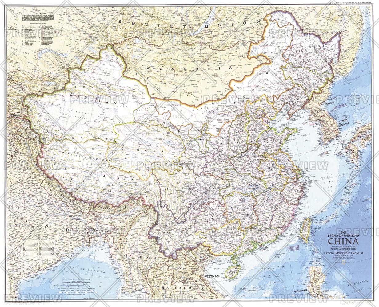
A powerful snapshot of a nation in transition, People’s Republic of China captures the geographic and political structure of China at a pivotal moment in its modern history. Published by National Geographic in July 1980, this map presents a clear, authoritative view of the country’s provinces, major cities, and infrastructure.
Issued alongside the companion Peoples of China map and the feature article “Shanghai: Born-again Giant,” it reflects a period when China was re-emerging onto the global stage—economically, politically, and culturally.
Why This Map Stands Out
A nation at a turning point
Captures China during a period of reform and global re-engagement.
Clear political structure
Shows provinces, boundaries, and major population centres.
Companion to a cultural map
Pairs with Peoples of China for a complete regional picture.
Large-format clarity
Expansive layout ensures legibility across a vast country.
A historical reference piece
Preserves a moment of transformation in late 20th-century China.
🗺️ What the Map Shows
🌏 Political Geography
- Provincial boundaries across the People’s Republic of China
- Major cities, including key centres such as Shanghai and Beijing
- Administrative regions and national structure
🛤️ Infrastructure & Connectivity
- Major transportation routes linking regions
- A framework showing how geography supports economic development
- The spatial organisation of a rapidly evolving nation
🌍 Regional Context
- China’s position within Asia
- Bordering countries and geographic relationships
- A sense of scale across one of the world’s largest nations
🌐 China in Transition
In 1980, China stood at a crossroads:
- Economic reforms were beginning to reshape society
- Cities like Shanghai were re-emerging as global centres
- Infrastructure and development were expanding rapidly
- A new era of openness was taking shape
This map captures that moment—offering a clear view of a country balancing tradition, structure, and change.
📐 Size & Format
950 mm (W) × 771 mm (H)
Landscape orientation (large format)
A commanding size ideal for:
- Classrooms and geography studies
- Universities and research environments
- Offices and planning spaces
- Feature walls and collections
✨ Premium Finishes & Display Options
Every People’s Republic of China (1980) map is produced using archival-grade materials and precision colour management, ensuring crisp detail and long-term durability.
📜 Heavyweight Paper (160 gsm Matte)
Classic. Refined. Frame-ready.
- Premium 160 gsm matte-coated archival paper
- Smooth, low-glare surface for readability
- Ideal for framing under glass
💡 Best for: traditional display and study.
🧼 Laminated (True Encapsulation — 2 × 80 Micron Gloss)
Durable. Practical. Built to last.
- Fully sealed with 2 × 80-micron laminate
- Edge-to-edge protection against wear and moisture
- Wipe-clean surface for annotation
💡 Best for: classrooms and working environments.
🪵 Laminated + Timber Hang Rails
Ready to hang. Clean lines. Contemporary feel.
- Natural timber rails (top & bottom), lacquered finish
- Includes hanging cord
- Keeps map flat without framing
🔨 Please allow up to 10 working days.
💡 Best for: modern, ready-to-hang display.
🖼️ Archival Canvas (395 gsm HP Professional Matte)
Textured. Elegant. Gallery-quality.
- Printed on 395 gsm HP Professional Matte Canvas
- Pigment-based inks for long-term colour stability
- Subtle texture enhances visual depth
💡 Best for: feature walls and premium interiors.
🪵 Canvas + Timber Hang Rails
Gallery-ready. Warm. Architectural.
- Canvas paired with natural timber rails
- Clean, balanced presentation
🔨 Please allow up to 10 working days.
💡 Best for: statement display spaces.
📊 Specifications
| Feature | Detail |
|---|---|
| Title | People’s Republic of China |
| Publisher | National Geographic |
| Published | 1980 |
| Dimensions | 950 mm × 771 mm |
| Orientation | Landscape |
| Map Type | Political |
| Coverage | China |
| Collections | Asia, Historical |
| Materials | 160 gsm matte paper · 2 × 80-micron laminate · 395 gsm HP Professional Matte Canvas |
| Inks | Pigment-based, fade-resistant |
| Origin | Printed in Australia |
🎯 Ideal For
- Students and educators of geography and modern history
- Researchers exploring China’s development and regional structure
- Collectors of National Geographic historical maps
- Interiors seeking a clean, authoritative wall map
- Gift buyers looking for a map with historical context
🌍 A Nation Re-Entering the World
This map represents more than geography:
- A country beginning a new phase of development
- A landscape of vast regional diversity
- A system of governance shaping a modern nation
- A moment captured just before decades of rapid change
It’s a map that offers perspective—showing China as it stood at the beginning of its modern transformation.
🤝 Our Commitment
- Printed in Australia using archival-quality materials
- Faithfully reproduced to preserve clarity and detail
- Premium finishes designed for long-term display
- Each map is hand-checked and carefully packed
🚚 Delivery
- Rolled (Paper, Laminated, Canvas): Dispatch within 1–2 business days
- Hang-Railed Finishes: Made to order — allow up to 10 working days
See China at a moment of change—
a map that captures the structure of a nation on the cusp of transformation.
Original: $50.05
-65%$50.05
$17.52Product Information
Product Information
Shipping & Returns
Shipping & Returns
Description
Political Landscape, Regions & Modern Context | Historical Wall Map | 950 × 771 mm | Premium Finishes
A powerful snapshot of a nation in transition, People’s Republic of China captures the geographic and political structure of China at a pivotal moment in its modern history. Published by National Geographic in July 1980, this map presents a clear, authoritative view of the country’s provinces, major cities, and infrastructure.
Issued alongside the companion Peoples of China map and the feature article “Shanghai: Born-again Giant,” it reflects a period when China was re-emerging onto the global stage—economically, politically, and culturally.
Why This Map Stands Out
A nation at a turning point
Captures China during a period of reform and global re-engagement.
Clear political structure
Shows provinces, boundaries, and major population centres.
Companion to a cultural map
Pairs with Peoples of China for a complete regional picture.
Large-format clarity
Expansive layout ensures legibility across a vast country.
A historical reference piece
Preserves a moment of transformation in late 20th-century China.
🗺️ What the Map Shows
🌏 Political Geography
- Provincial boundaries across the People’s Republic of China
- Major cities, including key centres such as Shanghai and Beijing
- Administrative regions and national structure
🛤️ Infrastructure & Connectivity
- Major transportation routes linking regions
- A framework showing how geography supports economic development
- The spatial organisation of a rapidly evolving nation
🌍 Regional Context
- China’s position within Asia
- Bordering countries and geographic relationships
- A sense of scale across one of the world’s largest nations
🌐 China in Transition
In 1980, China stood at a crossroads:
- Economic reforms were beginning to reshape society
- Cities like Shanghai were re-emerging as global centres
- Infrastructure and development were expanding rapidly
- A new era of openness was taking shape
This map captures that moment—offering a clear view of a country balancing tradition, structure, and change.
📐 Size & Format
950 mm (W) × 771 mm (H)
Landscape orientation (large format)
A commanding size ideal for:
- Classrooms and geography studies
- Universities and research environments
- Offices and planning spaces
- Feature walls and collections
✨ Premium Finishes & Display Options
Every People’s Republic of China (1980) map is produced using archival-grade materials and precision colour management, ensuring crisp detail and long-term durability.
📜 Heavyweight Paper (160 gsm Matte)
Classic. Refined. Frame-ready.
- Premium 160 gsm matte-coated archival paper
- Smooth, low-glare surface for readability
- Ideal for framing under glass
💡 Best for: traditional display and study.
🧼 Laminated (True Encapsulation — 2 × 80 Micron Gloss)
Durable. Practical. Built to last.
- Fully sealed with 2 × 80-micron laminate
- Edge-to-edge protection against wear and moisture
- Wipe-clean surface for annotation
💡 Best for: classrooms and working environments.
🪵 Laminated + Timber Hang Rails
Ready to hang. Clean lines. Contemporary feel.
- Natural timber rails (top & bottom), lacquered finish
- Includes hanging cord
- Keeps map flat without framing
🔨 Please allow up to 10 working days.
💡 Best for: modern, ready-to-hang display.
🖼️ Archival Canvas (395 gsm HP Professional Matte)
Textured. Elegant. Gallery-quality.
- Printed on 395 gsm HP Professional Matte Canvas
- Pigment-based inks for long-term colour stability
- Subtle texture enhances visual depth
💡 Best for: feature walls and premium interiors.
🪵 Canvas + Timber Hang Rails
Gallery-ready. Warm. Architectural.
- Canvas paired with natural timber rails
- Clean, balanced presentation
🔨 Please allow up to 10 working days.
💡 Best for: statement display spaces.
📊 Specifications
| Feature | Detail |
|---|---|
| Title | People’s Republic of China |
| Publisher | National Geographic |
| Published | 1980 |
| Dimensions | 950 mm × 771 mm |
| Orientation | Landscape |
| Map Type | Political |
| Coverage | China |
| Collections | Asia, Historical |
| Materials | 160 gsm matte paper · 2 × 80-micron laminate · 395 gsm HP Professional Matte Canvas |
| Inks | Pigment-based, fade-resistant |
| Origin | Printed in Australia |
🎯 Ideal For
- Students and educators of geography and modern history
- Researchers exploring China’s development and regional structure
- Collectors of National Geographic historical maps
- Interiors seeking a clean, authoritative wall map
- Gift buyers looking for a map with historical context
🌍 A Nation Re-Entering the World
This map represents more than geography:
- A country beginning a new phase of development
- A landscape of vast regional diversity
- A system of governance shaping a modern nation
- A moment captured just before decades of rapid change
It’s a map that offers perspective—showing China as it stood at the beginning of its modern transformation.
🤝 Our Commitment
- Printed in Australia using archival-quality materials
- Faithfully reproduced to preserve clarity and detail
- Premium finishes designed for long-term display
- Each map is hand-checked and carefully packed
🚚 Delivery
- Rolled (Paper, Laminated, Canvas): Dispatch within 1–2 business days
- Hang-Railed Finishes: Made to order — allow up to 10 working days
See China at a moment of change—
a map that captures the structure of a nation on the cusp of transformation.


