By National Geographic – Published December 2007
Size: 510 mm (W) x 790 mm (H)
Finish Options: Paper | Laminated | Canvas
Optional timber hang rails for laminated and canvas versions.
🌍 Step Into a Lost World of Dinosaurs
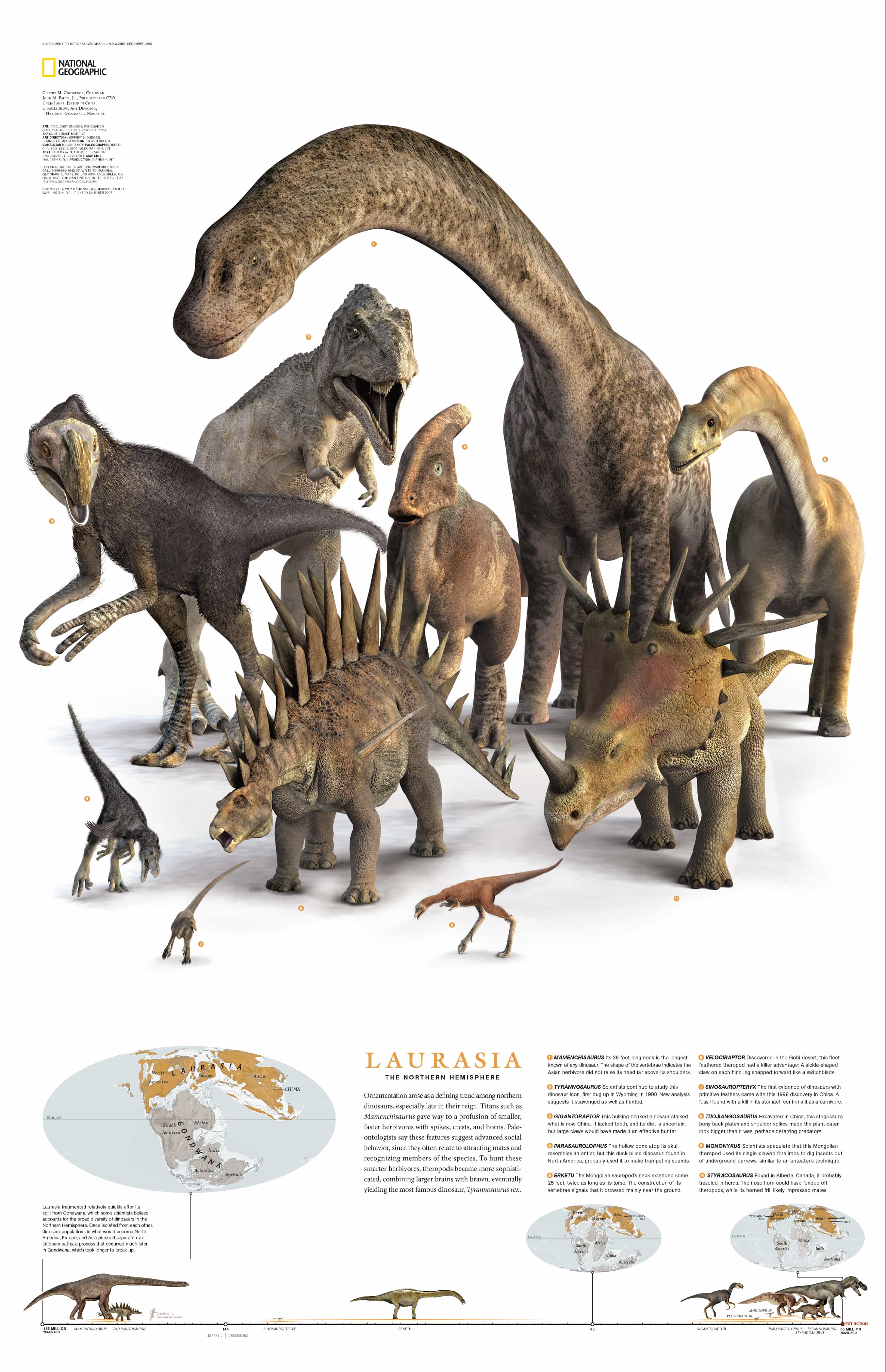
Travel back in time to the Mesozoic Era with this beautifully illustrated wall map, published by National Geographic in 2007. "Planet of the Dinosaurs: Laurasia" captures the essence of prehistoric Earth when the ancient supercontinent Pangaea split into two vast landmasses: Laurasia in the north and Gondwana in the south.
As the continents drifted apart, so too did the evolution of the dinosaurs that lived upon them. This map spotlights 10 magnificent species that once roamed the forests, plains, and floodplains of Laurasia — a rich and varied realm that would one day form North America, Europe, and parts of Asia.
Whether you're a teacher, dinosaur lover, or map collector, this stunning piece brings ancient life and global geography together in one eye-catching educational display.
🦕 Features You'll Love
-
Ten scientifically accurate dinosaur illustrations from the Laurasian lineage
-
Historical context: the breakup of Pangaea and dinosaur divergence
-
Perfect for classrooms, homeschooling, museums, and dino-loving kids
-
Created by National Geographic’s award-winning cartographic team
-
Rich colours, fine detail, and durable construction for years of enjoyment
🎨 Three Premium Finish Options
Choose a finish that suits your setting:
📄 160gsm Matte Art Paper
-
Smooth, archival-grade surface
-
Ideal for professional framing under glass
-
Ships rolled and ready for display
💧 Laminated – Gloss Encapsulation
-
Protected with true encapsulation between two 80-micron gloss laminate sheets
-
Durable, tear-resistant and waterproof
-
Write on and wipe off with whiteboard markers
-
🪵 Optional timber hang rails available for a clean, ready-to-hang finish
🖼️ Premium Canvas – 395gsm HP Matte
-
Printed on heavyweight, gallery-quality canvas
-
Uses archival pigment-based inks for exceptional colour and fade resistance
-
Rich texture and professional clarity
-
🪵 Optional timber hang rails give a warm, natural display style
🪵 Optional Timber Hang Rails
Available for both laminated and canvas versions, our natural timber hang rails transform your map into a display piece that’s ready to hang out of the box:
-
Made from durable, lacquered timber
-
Top and bottom rails ensure the map hangs straight and flat
-
Pre-attached hanging cord makes wall mounting effortless
-
Ideal for educational spaces, bedrooms, studios, and retail
⏳ Please allow 10 working days for hang-railed maps, as these are custom-fitted by our professional framer.
📐 Specifications
| Attribute | Details |
|---|---|
| Title | Planet of the Dinosaurs: Laurasia |
| Publisher | National Geographic |
| Date Published | December 2007 |
| Map Content | 10 Laurasian dinosaurs, Pangaea breakup context |
| Map Size | 510 mm (W) × 790 mm (H) |
| Finish Options | Paper / Laminated / Canvas |
| Lamination | 2 × 80-micron gloss sheets (encapsulated) |
| Canvas Stock | 395gsm HP Professional Matte Canvas |
| Ink Type | Pigment-based, archival-quality inks |
| Timber Hang Rails | Optional – available for both Laminated & Canvas formats |
| Dispatch Time (hang rails) | Up to 10 working days |
| Printed In | Australia |
👪 Who Is This Map Perfect For?
-
🧒 Young explorers fascinated by dinosaurs and ancient history
-
🏫 Teachers and homeschooling parents looking for a captivating visual aid
-
📚 Libraries and museums curating natural history displays
-
🖼️ Interior designers and collectors adding scientific charm to decor
-
🧭 Map and fossil lovers wanting a unique, conversation-starting piece
🛒 How to Order
-
Choose your preferred format (Paper, Laminated, or Canvas)
-
Select Optional Timber Hang Rails if desired
-
Add to cart and complete your order
-
Receive a timeless educational artwork, printed and shipped from Australia
✅ Map is shipped rolled for protection.
📦 Hang rails are fitted to order – allow up to 10 working days before dispatch.
From the lush lowlands of Laurasia to your wall, this National Geographic classic brings the prehistoric past to life — beautifully printed and built to last.