Quebec Wall Map 610 x 914mm
Physical & Political Detail | St. Lawrence to Nunavik | Relief Shading | Premium Finishes
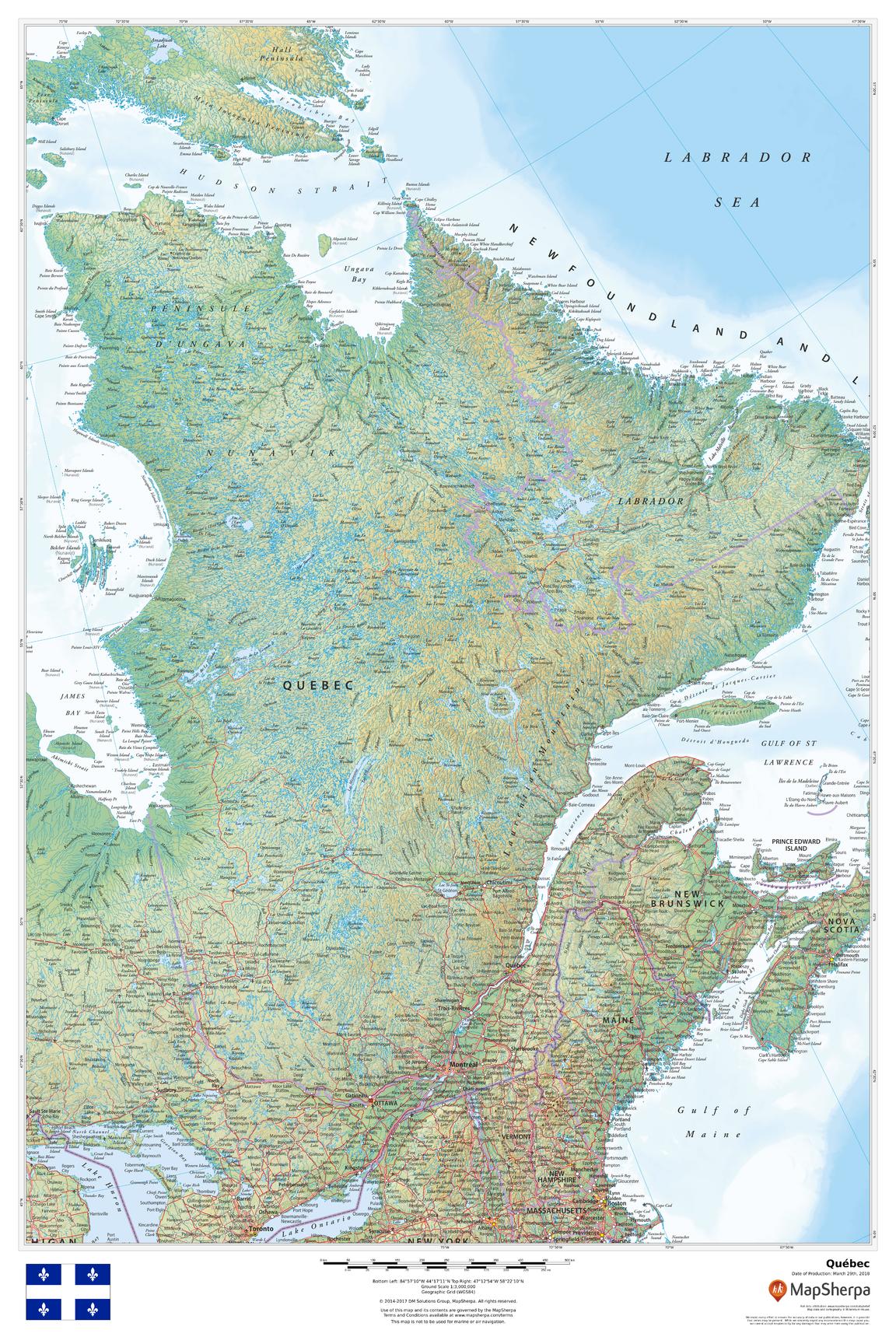
Discover Québec at wall scale—from the Gaspé Peninsula and Laurentian Mountains to the northern reaches of Nunavik, with the St. Lawrence River corridor linking Montréal, Québec City, and the Gulf. This large-format map combines clear political boundaries with beautiful physical cartography. Subtle relief shading and elevation colour-bands make the province’s varied landscapes instantly legible, while cities, roads, rail lines, and borders provide everyday utility for learning, planning, and display.
🗺️ Map Features (Expanded)
-
Physical + Political Layers – Provincial outline, administrative regions (where shown), cities/towns, highways and rail atop a refined terrain base.
-
Relief & Elevation – Hypsometric tints and hillshading highlight the Canadian Shield, Laurentians, Appalachians, and lowlands.
-
Water & Coastlines – Clear depiction of the St. Lawrence River & Gulf, Saguenay Fjord, Lac Saint-Jean, James & Hudson Bays, reservoirs, and major river systems.
-
Northern Context – Extensive northern geography (taiga, tundra, fjords, bays) for true province-wide orientation.
-
Urban Focus – Readable labeling for key centres including Montréal, Québec City, Laval, Gatineau, Sherbrooke, Trois-Rivières, Saguenay, and more (as depicted).
-
Wall-Optimised Cartography – Disciplined label hierarchy and crisp symbology ensure clarity without clutter from typical viewing distances.
All features appear as depicted on the printed map.
🌍 Regional Highlights
-
St. Lawrence Axis – Trace the heart of settlement, culture, and commerce from Montréal to Québec City and out to the Gulf.
-
Shield Country – Appreciate the sculpted lakes and rock of the Canadian Shield and vast hydrographic basins.
-
Maritime Québec – Follow the coastline around Gaspésie, the Lower North Shore, and into the Gulf of St. Lawrence.
-
Far North – See how communities relate to Hudson, James, and Ungava bays and Quebec’s northern ecozones.
🎓 Who It’s For
-
Educators & Students – Perfect for lessons on landforms, hydrology, settlement, and regional economies.
-
Travel & Outdoor Planners – Orient road trips, cycling routes, paddling, and hiking across regions.
-
Businesses & Organisations – Context for service regions, logistics, campaigns, and stakeholder briefings.
-
Home & Office Décor – A sophisticated focal point that’s both informative and beautiful.
✨ Available Finishes
| Format | Description |
|---|---|
| 📜 Paper (160 gsm) | Heavyweight matte-coated paper—ideal for framing under glass. |
| 🧼 Laminated (Encapsulated) | Fully sealed in 80-micron gloss laminate—durable, wipe-clean, great for notes. |
| 🪵 Laminated with Wooden Hang Rails | Laminated map mounted with lacquered natural timber rails (top & bottom) and a hanging cord—ready to display. |
| 🖼️ Canvas (395 gsm) | HP Professional Matte Canvas with archival pigment-based inks—rich texture, fade-resistant, gallery-grade. |
| 🪵 Canvas with Wooden Hang Rails | Canvas finished with lacquered timber rails and a hanging cord—timeless, frame-free presentation. |
🔨 Hang-railed maps are made to order—please allow up to 10 working days for professional mounting.
📐 Specifications
| Feature | Detail |
|---|---|
| Title | Quebec Wall Map |
| Map Type | Physical / Political |
| Scale | 1:3,000,000 (≈ 1 cm = 30 km) |
| Dimensions | 610 mm (W) × 914 mm (H) |
| Orientation | Portrait |
| Materials | Paper, Laminated, Canvas, With or Without Timber Rails |
| Printing | Archival pigment-based inks, fade-resistant |
💡 Why You’ll Love It
-
Landscape clarity—mountains, shield, valleys, and coasts come alive in elegant relief.
-
Everyday utility—clear routes, cities, and regions aid planning and teaching.
-
Display-ready—five premium finishes suit classrooms, offices, studios, and living spaces.
-
Built to last—laminated/canvas options handle frequent use and remain colour-true.
🚚 Delivery
-
Paper, Laminated & Canvas (rolled): Usually ships within 1–2 business days.
-
Hang-railed versions: Made to order; allow up to 10 working days.
-
Packaging: Securely protected to arrive in pristine condition.
Bring Québec’s rivers, ranges, and regions into daily focus. Choose your finish, hang with ease, and enjoy a map that informs, inspires, and elevates your space.
Original: $57.20
-65%$57.20
$20.02Product Information
Product Information
Shipping & Returns
Shipping & Returns
Description
Physical & Political Detail | St. Lawrence to Nunavik | Relief Shading | Premium Finishes
Discover Québec at wall scale—from the Gaspé Peninsula and Laurentian Mountains to the northern reaches of Nunavik, with the St. Lawrence River corridor linking Montréal, Québec City, and the Gulf. This large-format map combines clear political boundaries with beautiful physical cartography. Subtle relief shading and elevation colour-bands make the province’s varied landscapes instantly legible, while cities, roads, rail lines, and borders provide everyday utility for learning, planning, and display.
🗺️ Map Features (Expanded)
-
Physical + Political Layers – Provincial outline, administrative regions (where shown), cities/towns, highways and rail atop a refined terrain base.
-
Relief & Elevation – Hypsometric tints and hillshading highlight the Canadian Shield, Laurentians, Appalachians, and lowlands.
-
Water & Coastlines – Clear depiction of the St. Lawrence River & Gulf, Saguenay Fjord, Lac Saint-Jean, James & Hudson Bays, reservoirs, and major river systems.
-
Northern Context – Extensive northern geography (taiga, tundra, fjords, bays) for true province-wide orientation.
-
Urban Focus – Readable labeling for key centres including Montréal, Québec City, Laval, Gatineau, Sherbrooke, Trois-Rivières, Saguenay, and more (as depicted).
-
Wall-Optimised Cartography – Disciplined label hierarchy and crisp symbology ensure clarity without clutter from typical viewing distances.
All features appear as depicted on the printed map.
🌍 Regional Highlights
-
St. Lawrence Axis – Trace the heart of settlement, culture, and commerce from Montréal to Québec City and out to the Gulf.
-
Shield Country – Appreciate the sculpted lakes and rock of the Canadian Shield and vast hydrographic basins.
-
Maritime Québec – Follow the coastline around Gaspésie, the Lower North Shore, and into the Gulf of St. Lawrence.
-
Far North – See how communities relate to Hudson, James, and Ungava bays and Quebec’s northern ecozones.
🎓 Who It’s For
-
Educators & Students – Perfect for lessons on landforms, hydrology, settlement, and regional economies.
-
Travel & Outdoor Planners – Orient road trips, cycling routes, paddling, and hiking across regions.
-
Businesses & Organisations – Context for service regions, logistics, campaigns, and stakeholder briefings.
-
Home & Office Décor – A sophisticated focal point that’s both informative and beautiful.
✨ Available Finishes
| Format | Description |
|---|---|
| 📜 Paper (160 gsm) | Heavyweight matte-coated paper—ideal for framing under glass. |
| 🧼 Laminated (Encapsulated) | Fully sealed in 80-micron gloss laminate—durable, wipe-clean, great for notes. |
| 🪵 Laminated with Wooden Hang Rails | Laminated map mounted with lacquered natural timber rails (top & bottom) and a hanging cord—ready to display. |
| 🖼️ Canvas (395 gsm) | HP Professional Matte Canvas with archival pigment-based inks—rich texture, fade-resistant, gallery-grade. |
| 🪵 Canvas with Wooden Hang Rails | Canvas finished with lacquered timber rails and a hanging cord—timeless, frame-free presentation. |
🔨 Hang-railed maps are made to order—please allow up to 10 working days for professional mounting.
📐 Specifications
| Feature | Detail |
|---|---|
| Title | Quebec Wall Map |
| Map Type | Physical / Political |
| Scale | 1:3,000,000 (≈ 1 cm = 30 km) |
| Dimensions | 610 mm (W) × 914 mm (H) |
| Orientation | Portrait |
| Materials | Paper, Laminated, Canvas, With or Without Timber Rails |
| Printing | Archival pigment-based inks, fade-resistant |
💡 Why You’ll Love It
-
Landscape clarity—mountains, shield, valleys, and coasts come alive in elegant relief.
-
Everyday utility—clear routes, cities, and regions aid planning and teaching.
-
Display-ready—five premium finishes suit classrooms, offices, studios, and living spaces.
-
Built to last—laminated/canvas options handle frequent use and remain colour-true.
🚚 Delivery
-
Paper, Laminated & Canvas (rolled): Usually ships within 1–2 business days.
-
Hang-railed versions: Made to order; allow up to 10 working days.
-
Packaging: Securely protected to arrive in pristine condition.
Bring Québec’s rivers, ranges, and regions into daily focus. Choose your finish, hang with ease, and enjoy a map that informs, inspires, and elevates your space.


