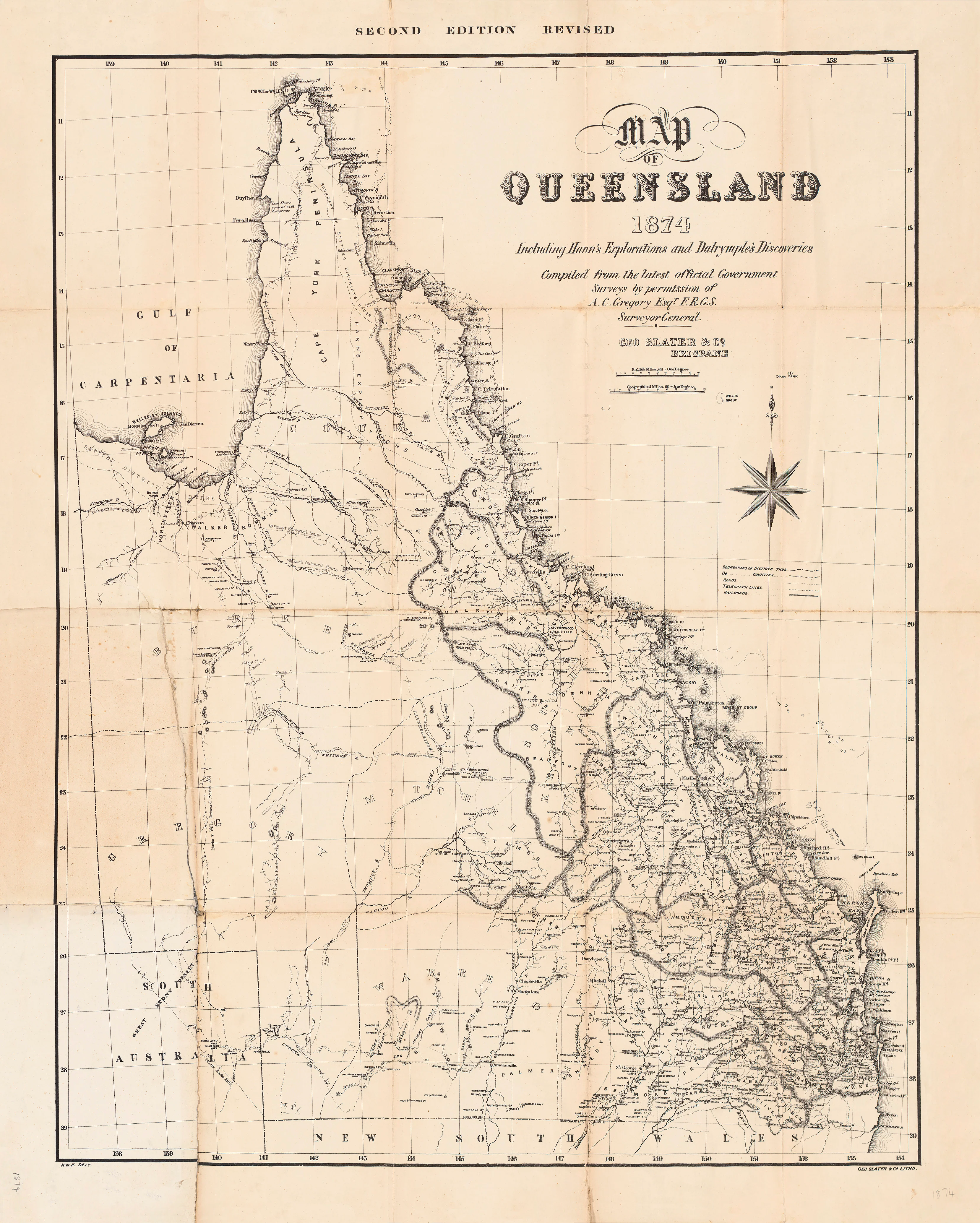
Queensland Map 1874 - Including Hann's Explorations & Dalrymple's Discoveries
Queensland Map (1874) — Including Hann’s Explorations & Dalrymple’s Discoveries
A handsome 19th-century wall map of Queensland capturing a colony in motion—coastlines, rivers and districts carefully engraved, with routes attributed to Frank Hann and G. E. Dalrymple marked from their inland surveys and coastal forays. A superb statement piece for historians, collectors and Australian interiors.
Why it captivates
-
Exploration era detail — routes and notes from Hann & Dalrymple lend immediacy and narrative.
-
Colonial cartography — fine linework, period typography, and richly toned shading.
-
Conversation starter — Queensland’s emerging towns, ports and pastoral districts at a glance.
-
Decor & research — beautiful on the wall, useful for teaching, genealogy and regional history.
-
Australian-made finish options — archival papers, canvas, and ready-to-hang rails.
What you’ll see
District boundaries, principal rivers and ranges, coastal soundings and ports, telegraphs/roads of the period, and expedition traces credited to Hann and Dalrymple, annotated across North and Far North Queensland. Insets and notes (where present in the original) provide additional geographic context.
Choose your finish
🌟 Heavyweight Paper (160 gsm matte)
Archival, smooth matte stock—ideal under glass. Clean tones, minimal glare.
💎 Laminated (True Encapsulation)
Sealed in 2 × 80-micron gloss laminate, edge-to-edge. Durable, wipe-clean—great for offices, classrooms and busy spaces.
🪵 Laminated + Timber Hang Rails (Ready to hang)
Natural lacquered timber rails with fitted hanging cord—no frame needed.
Please allow up to 10 working days for hang-railed delivery.
🏆 Archival Canvas (395 gsm HP Professional Matte)
Museum-quality texture with pigment-based, fade-resistant inks for deep, stable colour.
🪵 Canvas + Timber Hang Rails (Gallery-ready)
Canvas supplied with lacquered timber rails and hanging cord.
Please allow up to 10 working days for hang-railed delivery.
Size (W × H)
800 × 1000 mm (approx. 31.5 × 39.4 in)
-
Orientation: Portrait
-
Aspect ratio: 4 : 5 (0.8 : 1)
-
Nearest standard frame: 800 × 1000 mm poster frame; or A0 (841 × 1189 mm) with a mat.
-
Framing tips: Cut the mat window to ~796 × 996 mm for a neat 2–3 mm overlap, or float-mount in a larger frame for a heritage look.
Custom sizing: Available on request (alternative ratios or added white border).
Specifications
| Feature | Details |
|---|---|
| Title | Queensland Map (1874) — Including Hann’s Explorations & Dalrymple’s Discoveries |
| Date (original) | 1874 |
| Content | Colonial Queensland with exploration routes attributed to Hann & Dalrymple |
| Print Size | 800 mm (W) × 1000 mm (H) |
| Available Finishes | Paper, Laminated, Laminated + Timber Hang Rails, Canvas, Canvas + Rails |
| Paper Weight | 160 gsm archival matte |
| Laminate | 2 × 80-micron gloss (true encapsulation) |
| Canvas Weight | 395 gsm HP Professional Matte Canvas |
| Inks | Pigment-based, fade-resistant |
| Optional Hang Rails | Natural timber, lacquered; fitted cord (allow up to 10 working days) |
| Origin | Printed in Australia |
Who it’s for
-
Australian history & exploration enthusiasts
-
Educators, libraries & museums
-
Genealogists tracing Queensland families and pastoral holdings
-
Interior stylists seeking refined vintage cartography
-
Gift-givers marking Queensland connections
Our Commitment
Printed locally in Australia on premium substrates with careful colour management, then checked and packed by hand so it arrives ready to impress.
Bring Queensland’s exploration era to your wall—order your 1874 map today.
Original: $50.05
-65%$50.05
$17.52Product Information
Product Information
Shipping & Returns
Shipping & Returns
Description
Queensland Map (1874) — Including Hann’s Explorations & Dalrymple’s Discoveries
A handsome 19th-century wall map of Queensland capturing a colony in motion—coastlines, rivers and districts carefully engraved, with routes attributed to Frank Hann and G. E. Dalrymple marked from their inland surveys and coastal forays. A superb statement piece for historians, collectors and Australian interiors.
Why it captivates
-
Exploration era detail — routes and notes from Hann & Dalrymple lend immediacy and narrative.
-
Colonial cartography — fine linework, period typography, and richly toned shading.
-
Conversation starter — Queensland’s emerging towns, ports and pastoral districts at a glance.
-
Decor & research — beautiful on the wall, useful for teaching, genealogy and regional history.
-
Australian-made finish options — archival papers, canvas, and ready-to-hang rails.
What you’ll see
District boundaries, principal rivers and ranges, coastal soundings and ports, telegraphs/roads of the period, and expedition traces credited to Hann and Dalrymple, annotated across North and Far North Queensland. Insets and notes (where present in the original) provide additional geographic context.
Choose your finish
🌟 Heavyweight Paper (160 gsm matte)
Archival, smooth matte stock—ideal under glass. Clean tones, minimal glare.
💎 Laminated (True Encapsulation)
Sealed in 2 × 80-micron gloss laminate, edge-to-edge. Durable, wipe-clean—great for offices, classrooms and busy spaces.
🪵 Laminated + Timber Hang Rails (Ready to hang)
Natural lacquered timber rails with fitted hanging cord—no frame needed.
Please allow up to 10 working days for hang-railed delivery.
🏆 Archival Canvas (395 gsm HP Professional Matte)
Museum-quality texture with pigment-based, fade-resistant inks for deep, stable colour.
🪵 Canvas + Timber Hang Rails (Gallery-ready)
Canvas supplied with lacquered timber rails and hanging cord.
Please allow up to 10 working days for hang-railed delivery.
Size (W × H)
800 × 1000 mm (approx. 31.5 × 39.4 in)
-
Orientation: Portrait
-
Aspect ratio: 4 : 5 (0.8 : 1)
-
Nearest standard frame: 800 × 1000 mm poster frame; or A0 (841 × 1189 mm) with a mat.
-
Framing tips: Cut the mat window to ~796 × 996 mm for a neat 2–3 mm overlap, or float-mount in a larger frame for a heritage look.
Custom sizing: Available on request (alternative ratios or added white border).
Specifications
| Feature | Details |
|---|---|
| Title | Queensland Map (1874) — Including Hann’s Explorations & Dalrymple’s Discoveries |
| Date (original) | 1874 |
| Content | Colonial Queensland with exploration routes attributed to Hann & Dalrymple |
| Print Size | 800 mm (W) × 1000 mm (H) |
| Available Finishes | Paper, Laminated, Laminated + Timber Hang Rails, Canvas, Canvas + Rails |
| Paper Weight | 160 gsm archival matte |
| Laminate | 2 × 80-micron gloss (true encapsulation) |
| Canvas Weight | 395 gsm HP Professional Matte Canvas |
| Inks | Pigment-based, fade-resistant |
| Optional Hang Rails | Natural timber, lacquered; fitted cord (allow up to 10 working days) |
| Origin | Printed in Australia |
Who it’s for
-
Australian history & exploration enthusiasts
-
Educators, libraries & museums
-
Genealogists tracing Queensland families and pastoral holdings
-
Interior stylists seeking refined vintage cartography
-
Gift-givers marking Queensland connections
Our Commitment
Printed locally in Australia on premium substrates with careful colour management, then checked and packed by hand so it arrives ready to impress.
Bring Queensland’s exploration era to your wall—order your 1874 map today.


