Queensland Map 1886 Illustrating its Mineral and other Productive Capabilities
Queensland Map (1886) — Illustrating Its Mineral and Other Productive Capabilities
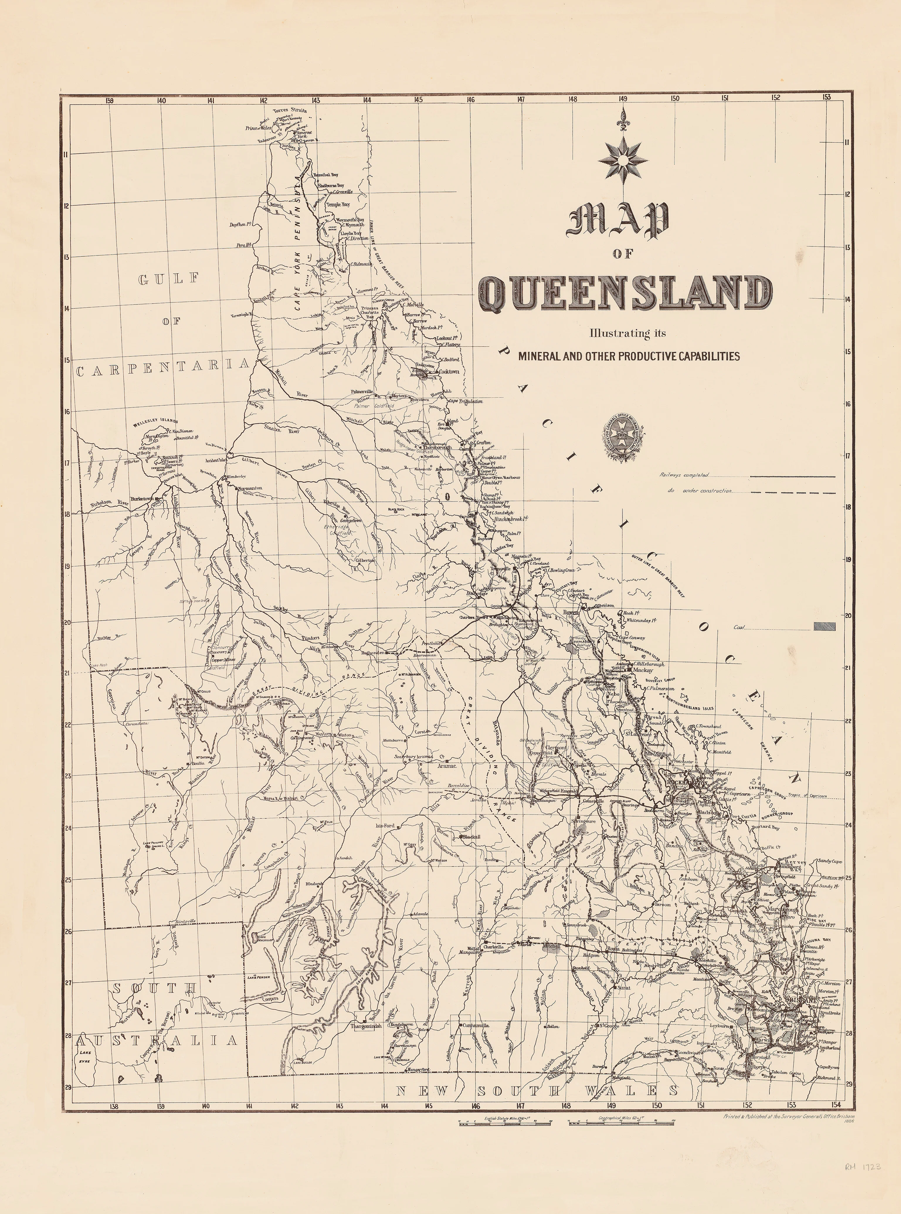
A striking and information-rich colonial Queensland map published in 1886 by the Surveyor-General’s Office, Brisbane, created to showcase the colony’s mineral wealth, agricultural regions, and productive capacity at the height of Queensland’s 19th-century expansion.
This is not just a geographic map—it is an economic statement. Designed to promote confidence, investment, and settlement, it presents Queensland as a land of resources, opportunity, and modern infrastructure.
Why it captivates
-
Government-issued authority — officially printed and published by the Surveyor-General’s Office, Brisbane.
-
Economic storytelling — highlights minerals, pastoral lands, agriculture, and productive districts.
-
Gold-rush era Queensland — reflects the colony at a moment of rapid growth and global ambition.
-
Wall-scale clarity — large, legible format designed to inform, persuade, and impress.
-
Rare thematic focus — far more than borders and towns, this map explains what Queensland could produce.
What you’ll see
This 1886 map presents Queensland with a strong thematic overlay of productivity, including:
-
Mining districts showing gold, copper, tin, coal, and other mineral resources
-
Pastoral and agricultural regions, clearly differentiated
-
Railways, ports, and transport routes linking resources to markets
-
Rivers, ranges, and geographic features essential to settlement and industry
-
Administrative boundaries and key towns, revealing how economic activity shaped governance
The result is a map that reads like a blueprint for development—confident, purposeful, and optimistic.
A richer historical frame
By 1886, Queensland had moved decisively into an era of resource-driven growth. Gold discoveries, expanding rail networks, and pastoral expansion transformed the colony into a vital contributor to the Australian and imperial economy.
Maps like this were produced to be displayed in government offices, exhibitions, boardrooms, and overseas agencies, reinforcing Queensland’s image as a productive, investable colony. Issued directly from the Surveyor-General’s Office, it carries both technical credibility and promotional intent.
This map captures Queensland not as wilderness—but as potential realised and potential promised.
Choose your finish
🌟 Heavyweight Paper (160 gsm matte)
Archival matte paper with excellent clarity and low glare—ideal for framing under glass.
💎 Laminated (True Encapsulation)
Protected edge-to-edge in 2 × 80-micron gloss laminate. Tough, wipe-clean, and suitable for working or public spaces.
🪵 Laminated + Timber Hang Rails (Ready to hang)
Natural lacquered timber rails with fitted hanging cord—no frame required.
Please allow up to 10 working days for hang-railed delivery.
🏆 Archival Canvas (395 gsm HP Professional Matte)
Museum-quality canvas printed with pigment-based, fade-resistant inks for depth and longevity.
🪵 Canvas + Timber Hang Rails (Gallery-ready)
Canvas supplied with lacquered natural timber rails and hanging cord.
Please allow up to 10 working days for hang-railed delivery.
Size (W × H)
742 × 1000 mm (approx. 29.2 × 39.4 in)
-
Orientation: Portrait
-
Aspect ratio: ~0.742 : 1
-
Nearest standard frame: A0 (841 × 1189 mm) with mat, or custom 742 × 1000 mm frame
-
Framing tips:
-
Classic: A0 frame with mat window cut to ~738 × 996 mm for a neat 2–3 mm overlap.
-
Contemporary: Float-mount within an A0 frame for a clean border reveal.
-
Custom sizing: Available on request.
Specifications
| Feature | Details |
|---|---|
| Title | Queensland — Illustrating Its Mineral and Other Productive Capabilities |
| Issuing Authority | Surveyor-General’s Office, Brisbane |
| Date (original) | 1886 |
| Content | Minerals, agriculture, pastoral districts, transport, settlements |
| Print Size | 742 mm (W) × 1000 mm (H) |
| Available Finishes | Paper, Laminated, Laminated + Timber Hang Rails, Canvas, Canvas + Rails |
| Paper Weight | 160 gsm archival matte |
| Laminate | 2 × 80-micron gloss (true encapsulation) |
| Canvas Weight | 395 gsm HP Professional Matte Canvas |
| Inks | Pigment-based, fade-resistant |
| Optional Hang Rails | Natural timber, lacquered; fitted cord (allow up to 10 working days) |
| Origin | Printed in Australia |
Who it’s for
-
Collectors of Australian colonial and economic maps
-
Mining, pastoral, and industrial heritage enthusiasts
-
Libraries, museums, and educational institutions
-
Boardrooms and offices celebrating Queensland’s resource history
-
Genealogists & historians tracing settlement and industry patterns
Our Commitment
Every map is printed locally in Australia on premium substrates with careful colour management, then hand-checked and packed with care. We honour the historical integrity of the original and the space it will live in.
Show Queensland as it proudly presented itself to the world—order the 1886 Queensland Productive Capabilities Map today.
Original: $50.05
-65%$50.05
$17.52Product Information
Product Information
Shipping & Returns
Shipping & Returns
Description
Queensland Map (1886) — Illustrating Its Mineral and Other Productive Capabilities
A striking and information-rich colonial Queensland map published in 1886 by the Surveyor-General’s Office, Brisbane, created to showcase the colony’s mineral wealth, agricultural regions, and productive capacity at the height of Queensland’s 19th-century expansion.
This is not just a geographic map—it is an economic statement. Designed to promote confidence, investment, and settlement, it presents Queensland as a land of resources, opportunity, and modern infrastructure.
Why it captivates
-
Government-issued authority — officially printed and published by the Surveyor-General’s Office, Brisbane.
-
Economic storytelling — highlights minerals, pastoral lands, agriculture, and productive districts.
-
Gold-rush era Queensland — reflects the colony at a moment of rapid growth and global ambition.
-
Wall-scale clarity — large, legible format designed to inform, persuade, and impress.
-
Rare thematic focus — far more than borders and towns, this map explains what Queensland could produce.
What you’ll see
This 1886 map presents Queensland with a strong thematic overlay of productivity, including:
-
Mining districts showing gold, copper, tin, coal, and other mineral resources
-
Pastoral and agricultural regions, clearly differentiated
-
Railways, ports, and transport routes linking resources to markets
-
Rivers, ranges, and geographic features essential to settlement and industry
-
Administrative boundaries and key towns, revealing how economic activity shaped governance
The result is a map that reads like a blueprint for development—confident, purposeful, and optimistic.
A richer historical frame
By 1886, Queensland had moved decisively into an era of resource-driven growth. Gold discoveries, expanding rail networks, and pastoral expansion transformed the colony into a vital contributor to the Australian and imperial economy.
Maps like this were produced to be displayed in government offices, exhibitions, boardrooms, and overseas agencies, reinforcing Queensland’s image as a productive, investable colony. Issued directly from the Surveyor-General’s Office, it carries both technical credibility and promotional intent.
This map captures Queensland not as wilderness—but as potential realised and potential promised.
Choose your finish
🌟 Heavyweight Paper (160 gsm matte)
Archival matte paper with excellent clarity and low glare—ideal for framing under glass.
💎 Laminated (True Encapsulation)
Protected edge-to-edge in 2 × 80-micron gloss laminate. Tough, wipe-clean, and suitable for working or public spaces.
🪵 Laminated + Timber Hang Rails (Ready to hang)
Natural lacquered timber rails with fitted hanging cord—no frame required.
Please allow up to 10 working days for hang-railed delivery.
🏆 Archival Canvas (395 gsm HP Professional Matte)
Museum-quality canvas printed with pigment-based, fade-resistant inks for depth and longevity.
🪵 Canvas + Timber Hang Rails (Gallery-ready)
Canvas supplied with lacquered natural timber rails and hanging cord.
Please allow up to 10 working days for hang-railed delivery.
Size (W × H)
742 × 1000 mm (approx. 29.2 × 39.4 in)
-
Orientation: Portrait
-
Aspect ratio: ~0.742 : 1
-
Nearest standard frame: A0 (841 × 1189 mm) with mat, or custom 742 × 1000 mm frame
-
Framing tips:
-
Classic: A0 frame with mat window cut to ~738 × 996 mm for a neat 2–3 mm overlap.
-
Contemporary: Float-mount within an A0 frame for a clean border reveal.
-
Custom sizing: Available on request.
Specifications
| Feature | Details |
|---|---|
| Title | Queensland — Illustrating Its Mineral and Other Productive Capabilities |
| Issuing Authority | Surveyor-General’s Office, Brisbane |
| Date (original) | 1886 |
| Content | Minerals, agriculture, pastoral districts, transport, settlements |
| Print Size | 742 mm (W) × 1000 mm (H) |
| Available Finishes | Paper, Laminated, Laminated + Timber Hang Rails, Canvas, Canvas + Rails |
| Paper Weight | 160 gsm archival matte |
| Laminate | 2 × 80-micron gloss (true encapsulation) |
| Canvas Weight | 395 gsm HP Professional Matte Canvas |
| Inks | Pigment-based, fade-resistant |
| Optional Hang Rails | Natural timber, lacquered; fitted cord (allow up to 10 working days) |
| Origin | Printed in Australia |
Who it’s for
-
Collectors of Australian colonial and economic maps
-
Mining, pastoral, and industrial heritage enthusiasts
-
Libraries, museums, and educational institutions
-
Boardrooms and offices celebrating Queensland’s resource history
-
Genealogists & historians tracing settlement and industry patterns
Our Commitment
Every map is printed locally in Australia on premium substrates with careful colour management, then hand-checked and packed with care. We honour the historical integrity of the original and the space it will live in.
Show Queensland as it proudly presented itself to the world—order the 1886 Queensland Productive Capabilities Map today.


