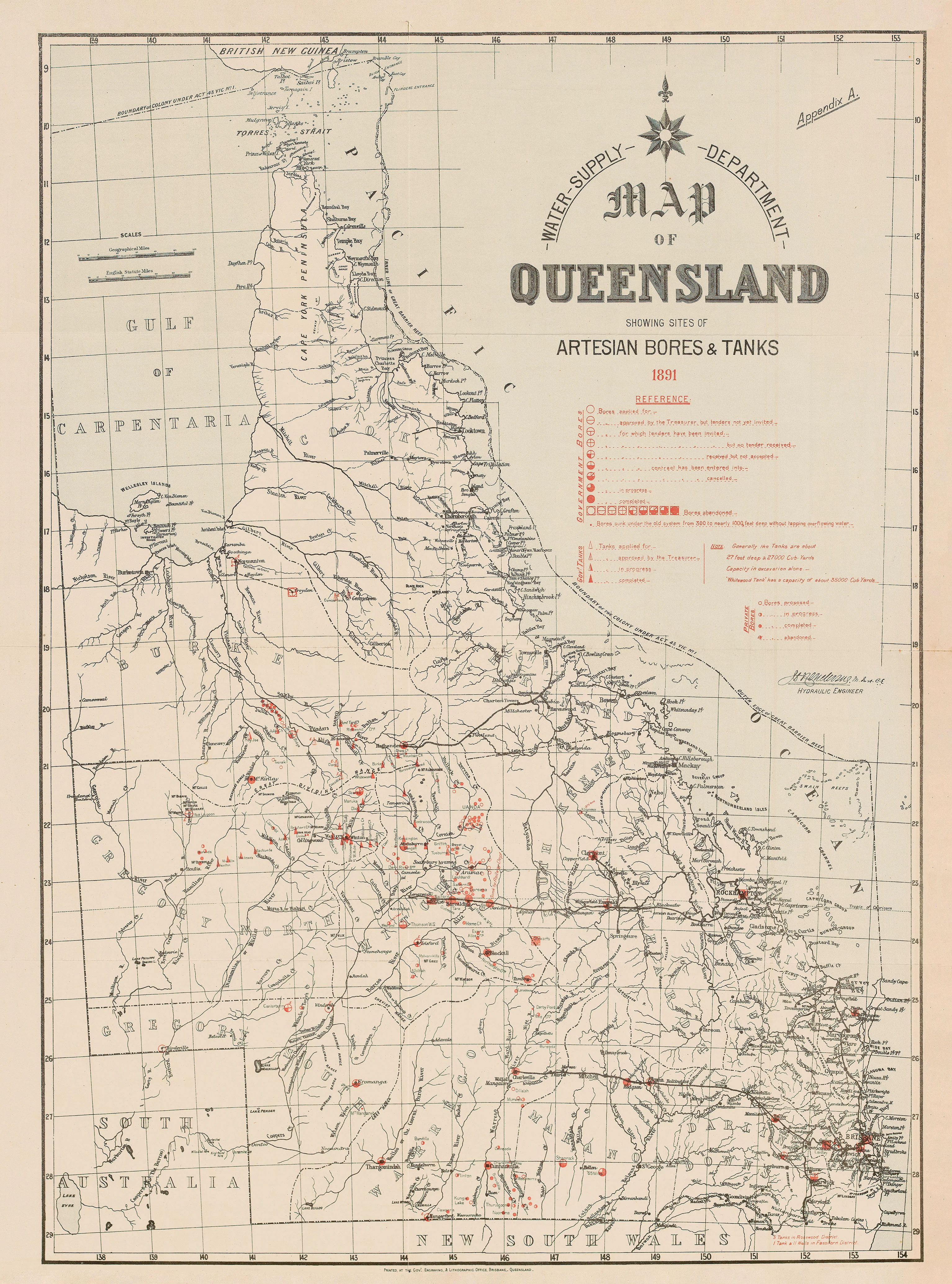
Queensland Map 1891 - Showing Sites of Artesian Bores & Tanks
Queensland Map (1891) — Showing Sites of Artesian Bores & Tanks
A striking late-19th-century Queensland wall map charting one of the colony’s most transformative developments: water. This detailed 1891 map documents the emerging network of artesian bores and tanks, revealing how inland settlement, stock routes, and pastoral expansion were made possible across Queensland’s arid heart.
Both historically significant and visually compelling, it’s an essential piece for understanding how water reshaped Queensland.
Why it captivates
-
Water as history — artesian bores and tanks mapped as lifelines of settlement.
-
Pastoral expansion — insight into grazing districts, stock routes, and inland infrastructure.
-
Technical cartography — clean linework, precise symbols, and authoritative colonial styling.
-
Rare thematic focus — few maps foreground water infrastructure so explicitly.
-
A powerful wall piece — balances documentary weight with elegant period design.
What you’ll see
Queensland laid out in full, with clearly marked sites of artesian bores and water tanks, overlaid on districts, rivers, railways, and emerging inland routes. Coastal regions contrast sharply with the mapped interior, where water points punctuate vast pastoral lands—telling a quiet but profound story of survival, engineering, and ambition.
Choose your finish
🌟 Heavyweight Paper (160 gsm matte)
Archival-grade matte paper—ideal for framing under glass with minimal glare.
💎 Laminated (True Encapsulation)
Protected with 2 × 80-micron gloss laminate, edge to edge. Hard-wearing and wipe-clean.
🪵 Laminated + Timber Hang Rails (Ready to hang)
Lacquered natural timber rails with fitted hanging cord—no frame required.
Please allow up to 10 working days for hang-railed delivery.
🏆 Archival Canvas (395 gsm HP Professional Matte)
Museum-quality canvas using pigment-based, fade-resistant inks for depth and longevity.
🪵 Canvas + Timber Hang Rails (Gallery-ready)
Canvas supplied with natural timber rails and hanging cord.
Please allow up to 10 working days for hang-railed delivery.
Size (W × H)
741 × 1000 mm (approx. 29.2 × 39.4 in)
-
Orientation: Portrait
-
Aspect ratio: ~0.741 : 1
-
Nearest standard frame: A0 (841 × 1189 mm) with mat, or custom 741 × 1000 mm frame
-
Framing tips:
-
Use a mat window cut to ~737 × 996 mm for a crisp archival overlap.
-
Float-mount in an A0 frame for a refined, museum-style presentation.
-
Custom sizing: Available on request (alternative borders or proportions).
Specifications
| Feature | Details |
|---|---|
| Title | Queensland Map (1891) — Showing Sites of Artesian Bores & Tanks |
| Date (original) | 1891 |
| Content | Queensland districts with mapped artesian bores and water tanks |
| Print Size | 741 mm (W) × 1000 mm (H) |
| Available Finishes | Paper, Laminated, Laminated + Timber Hang Rails, Canvas, Canvas + Rails |
| Paper Weight | 160 gsm archival matte |
| Laminate | 2 × 80-micron gloss (true encapsulation) |
| Canvas Weight | 395 gsm HP Professional Matte Canvas |
| Inks | Pigment-based, fade-resistant |
| Optional Hang Rails | Natural timber, lacquered; fitted cord (allow up to 10 working days) |
| Origin | Printed in Australia |
Who it’s for
-
Queensland historians & researchers
-
Pastoral, agricultural & water-management professionals
-
Educators and libraries
-
Genealogists tracing inland settlement patterns
-
Interior stylists seeking meaningful Australian cartography
Our Commitment
Printed locally in Australia on premium substrates, colour-managed for fidelity, then hand-checked and packed with care.
Trace the lifelines of inland Queensland—order your 1891 Artesian Bores & Tanks map today.
Original: $50.05
-65%$50.05
$17.52Product Information
Product Information
Shipping & Returns
Shipping & Returns
Description
Queensland Map (1891) — Showing Sites of Artesian Bores & Tanks
A striking late-19th-century Queensland wall map charting one of the colony’s most transformative developments: water. This detailed 1891 map documents the emerging network of artesian bores and tanks, revealing how inland settlement, stock routes, and pastoral expansion were made possible across Queensland’s arid heart.
Both historically significant and visually compelling, it’s an essential piece for understanding how water reshaped Queensland.
Why it captivates
-
Water as history — artesian bores and tanks mapped as lifelines of settlement.
-
Pastoral expansion — insight into grazing districts, stock routes, and inland infrastructure.
-
Technical cartography — clean linework, precise symbols, and authoritative colonial styling.
-
Rare thematic focus — few maps foreground water infrastructure so explicitly.
-
A powerful wall piece — balances documentary weight with elegant period design.
What you’ll see
Queensland laid out in full, with clearly marked sites of artesian bores and water tanks, overlaid on districts, rivers, railways, and emerging inland routes. Coastal regions contrast sharply with the mapped interior, where water points punctuate vast pastoral lands—telling a quiet but profound story of survival, engineering, and ambition.
Choose your finish
🌟 Heavyweight Paper (160 gsm matte)
Archival-grade matte paper—ideal for framing under glass with minimal glare.
💎 Laminated (True Encapsulation)
Protected with 2 × 80-micron gloss laminate, edge to edge. Hard-wearing and wipe-clean.
🪵 Laminated + Timber Hang Rails (Ready to hang)
Lacquered natural timber rails with fitted hanging cord—no frame required.
Please allow up to 10 working days for hang-railed delivery.
🏆 Archival Canvas (395 gsm HP Professional Matte)
Museum-quality canvas using pigment-based, fade-resistant inks for depth and longevity.
🪵 Canvas + Timber Hang Rails (Gallery-ready)
Canvas supplied with natural timber rails and hanging cord.
Please allow up to 10 working days for hang-railed delivery.
Size (W × H)
741 × 1000 mm (approx. 29.2 × 39.4 in)
-
Orientation: Portrait
-
Aspect ratio: ~0.741 : 1
-
Nearest standard frame: A0 (841 × 1189 mm) with mat, or custom 741 × 1000 mm frame
-
Framing tips:
-
Use a mat window cut to ~737 × 996 mm for a crisp archival overlap.
-
Float-mount in an A0 frame for a refined, museum-style presentation.
-
Custom sizing: Available on request (alternative borders or proportions).
Specifications
| Feature | Details |
|---|---|
| Title | Queensland Map (1891) — Showing Sites of Artesian Bores & Tanks |
| Date (original) | 1891 |
| Content | Queensland districts with mapped artesian bores and water tanks |
| Print Size | 741 mm (W) × 1000 mm (H) |
| Available Finishes | Paper, Laminated, Laminated + Timber Hang Rails, Canvas, Canvas + Rails |
| Paper Weight | 160 gsm archival matte |
| Laminate | 2 × 80-micron gloss (true encapsulation) |
| Canvas Weight | 395 gsm HP Professional Matte Canvas |
| Inks | Pigment-based, fade-resistant |
| Optional Hang Rails | Natural timber, lacquered; fitted cord (allow up to 10 working days) |
| Origin | Printed in Australia |
Who it’s for
-
Queensland historians & researchers
-
Pastoral, agricultural & water-management professionals
-
Educators and libraries
-
Genealogists tracing inland settlement patterns
-
Interior stylists seeking meaningful Australian cartography
Our Commitment
Printed locally in Australia on premium substrates, colour-managed for fidelity, then hand-checked and packed with care.
Trace the lifelines of inland Queensland—order your 1891 Artesian Bores & Tanks map today.


