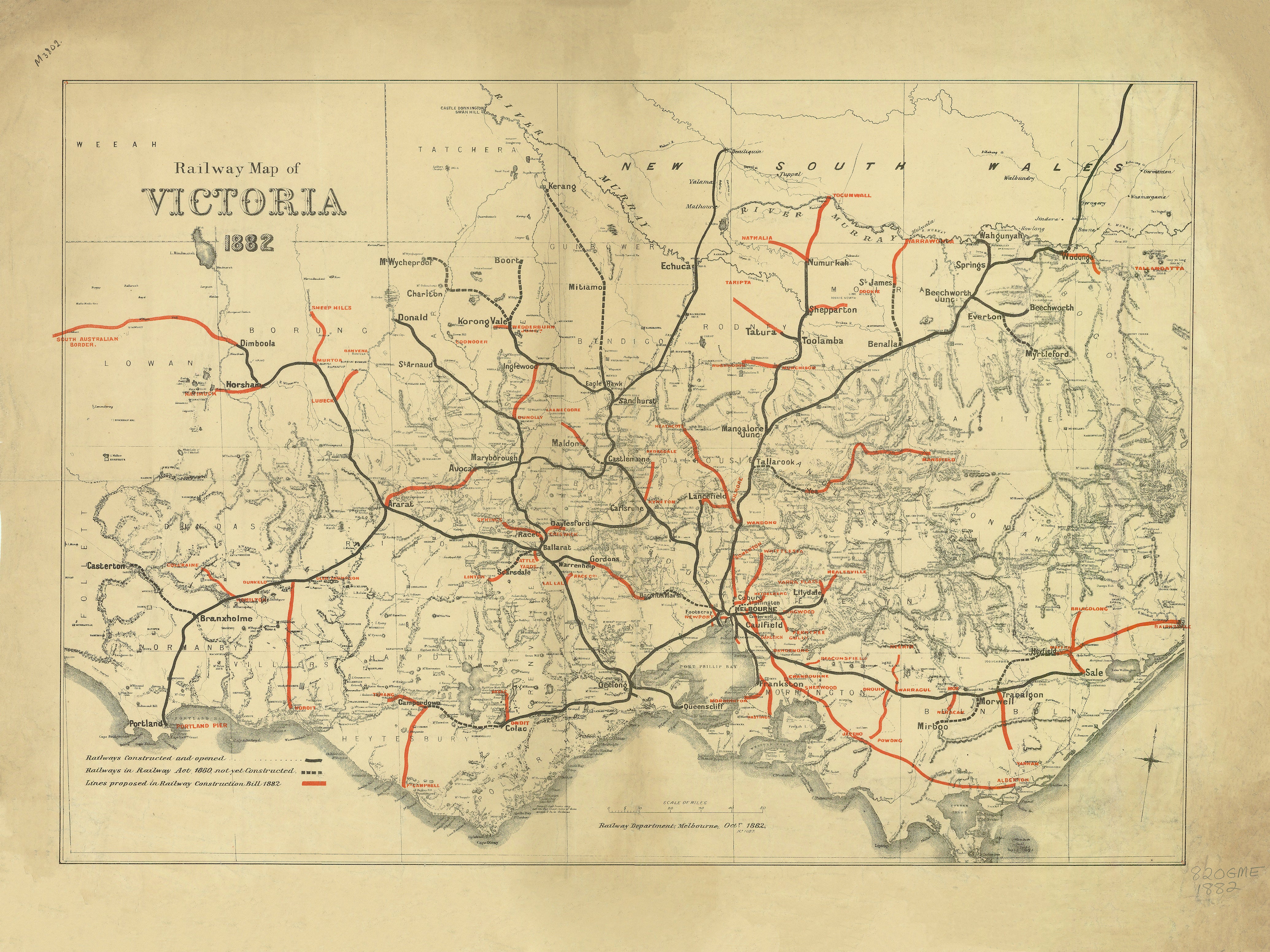
Railway Map of Victoria (1882)
1882 — State of Victoria
Railway Map of Victoria
Official Victorian Railways Map
This 1882 Railway Map of Victoria was issued by the Victorian Railways at a moment when rail had become the engine of the colony’s economic and social transformation. More than a transport diagram, the map is a strategic snapshot of how Victoria was being knitted together—linking Melbourne to ports, goldfields, agricultural districts, and emerging regional centres.
Prepared as an authoritative government working map, it balances clarity with breadth. Lines are drawn with confidence, stations and junctions are crisply named, and the statewide network is presented as a coherent system rather than a collection of local routes. The result is a document that reads equally well as infrastructure planning, economic history, and cartographic craft.
🚆 What the Map Shows
-
The Victorian railway network as it stood in 1882, radiating from Melbourne across the colony
-
Main trunk lines and branch lines, revealing priorities in freight, passenger movement, and regional access
-
Connections to ports and resource districts, underscoring rail’s role in trade and export
-
A clear, legible statewide view designed for administrative and operational reference
At a glance, the map explains why rail shaped settlement patterns so decisively—towns prosper where the lines run, and fade where they do not.
📜 Historical Context
By 1882, Victoria was deep into its railway age. The gold rushes had matured into sustained mining economies, wheat and wool were flowing from inland districts, and Melbourne was asserting itself as a modern colonial capital. Railways were the essential connective tissue, enabling speed, scale, and reliability unimaginable a generation earlier.
This map captures the network before the final wave of late-nineteenth-century expansion and before twentieth-century rationalisation. It preserves a formative configuration—when optimism in rail-led progress was at its peak and the system was still growing outward in confidence.
🧭 Cartographic Character & Design
-
Produced to late-19th-century Victorian Railways standards
-
Functional layout with strong hierarchy and restrained typography
-
Emphasis on network legibility over ornamentation
-
A classic example of colonial infrastructure cartography—precise, purposeful, and authoritative
This is cartography in service of nation-building: maps made to guide investment, planning, and public understanding.
✨ Premium Print & Display Options
Each copy is printed in Australia using archival processes to preserve the original linework, colour relationships, and historical character of the 1882 map.
| Finish | Description |
|---|---|
| 📄 Heavyweight Paper (160 gsm matte) | Archival matte surface with excellent definition. |
| 🔒 Laminated (True Encapsulation) | Sealed between 2 × 80-micron gloss laminate; tear-resistant and wipe-clean. |
| 🎨 Archival Canvas (395 gsm HP Professional Matte) | Pigment-based, fade-resistant inks with strong visual presence. |
| 🪵 Laminated + Timber Hang Rails | Natural lacquered timber rails, ready to hang (allow up to 10 working days). |
| 🪵 Canvas + Timber Hang Rails | Gallery-ready, frame-free finish (allow up to 10 working days). |
📐 Size (W × H)
-
1000 mm × 750 mm
-
Orientation: Landscape
-
Custom sizing: Available on request
🎯 Ideal For
-
Australian railway and transport history collections
-
Victorian regional and economic history research
-
Government buildings and heritage offices
-
Universities, libraries, and museums
-
Collectors of colonial infrastructure and railway ephemera
🤝 Our Commitment
Printed locally in Australia, every map is carefully colour-managed, inspected, and packed to ensure the finished piece faithfully reflects the authority and intent of the original 1882 Victorian Railways publication.
A powerful visual record of how rail shaped Victoria—line by line, town by town.
Original: $64.36
-65%$64.36
$22.53Product Information
Product Information
Shipping & Returns
Shipping & Returns
Description
1882 — State of Victoria
Railway Map of Victoria
Official Victorian Railways Map
This 1882 Railway Map of Victoria was issued by the Victorian Railways at a moment when rail had become the engine of the colony’s economic and social transformation. More than a transport diagram, the map is a strategic snapshot of how Victoria was being knitted together—linking Melbourne to ports, goldfields, agricultural districts, and emerging regional centres.
Prepared as an authoritative government working map, it balances clarity with breadth. Lines are drawn with confidence, stations and junctions are crisply named, and the statewide network is presented as a coherent system rather than a collection of local routes. The result is a document that reads equally well as infrastructure planning, economic history, and cartographic craft.
🚆 What the Map Shows
-
The Victorian railway network as it stood in 1882, radiating from Melbourne across the colony
-
Main trunk lines and branch lines, revealing priorities in freight, passenger movement, and regional access
-
Connections to ports and resource districts, underscoring rail’s role in trade and export
-
A clear, legible statewide view designed for administrative and operational reference
At a glance, the map explains why rail shaped settlement patterns so decisively—towns prosper where the lines run, and fade where they do not.
📜 Historical Context
By 1882, Victoria was deep into its railway age. The gold rushes had matured into sustained mining economies, wheat and wool were flowing from inland districts, and Melbourne was asserting itself as a modern colonial capital. Railways were the essential connective tissue, enabling speed, scale, and reliability unimaginable a generation earlier.
This map captures the network before the final wave of late-nineteenth-century expansion and before twentieth-century rationalisation. It preserves a formative configuration—when optimism in rail-led progress was at its peak and the system was still growing outward in confidence.
🧭 Cartographic Character & Design
-
Produced to late-19th-century Victorian Railways standards
-
Functional layout with strong hierarchy and restrained typography
-
Emphasis on network legibility over ornamentation
-
A classic example of colonial infrastructure cartography—precise, purposeful, and authoritative
This is cartography in service of nation-building: maps made to guide investment, planning, and public understanding.
✨ Premium Print & Display Options
Each copy is printed in Australia using archival processes to preserve the original linework, colour relationships, and historical character of the 1882 map.
| Finish | Description |
|---|---|
| 📄 Heavyweight Paper (160 gsm matte) | Archival matte surface with excellent definition. |
| 🔒 Laminated (True Encapsulation) | Sealed between 2 × 80-micron gloss laminate; tear-resistant and wipe-clean. |
| 🎨 Archival Canvas (395 gsm HP Professional Matte) | Pigment-based, fade-resistant inks with strong visual presence. |
| 🪵 Laminated + Timber Hang Rails | Natural lacquered timber rails, ready to hang (allow up to 10 working days). |
| 🪵 Canvas + Timber Hang Rails | Gallery-ready, frame-free finish (allow up to 10 working days). |
📐 Size (W × H)
-
1000 mm × 750 mm
-
Orientation: Landscape
-
Custom sizing: Available on request
🎯 Ideal For
-
Australian railway and transport history collections
-
Victorian regional and economic history research
-
Government buildings and heritage offices
-
Universities, libraries, and museums
-
Collectors of colonial infrastructure and railway ephemera
🤝 Our Commitment
Printed locally in Australia, every map is carefully colour-managed, inspected, and packed to ensure the finished piece faithfully reflects the authority and intent of the original 1882 Victorian Railways publication.
A powerful visual record of how rail shaped Victoria—line by line, town by town.


