Republic of the Congo Wall Map 864 x 1118mm
Physical & Political Detail | Congo Basin Rivers | Premium Finishes
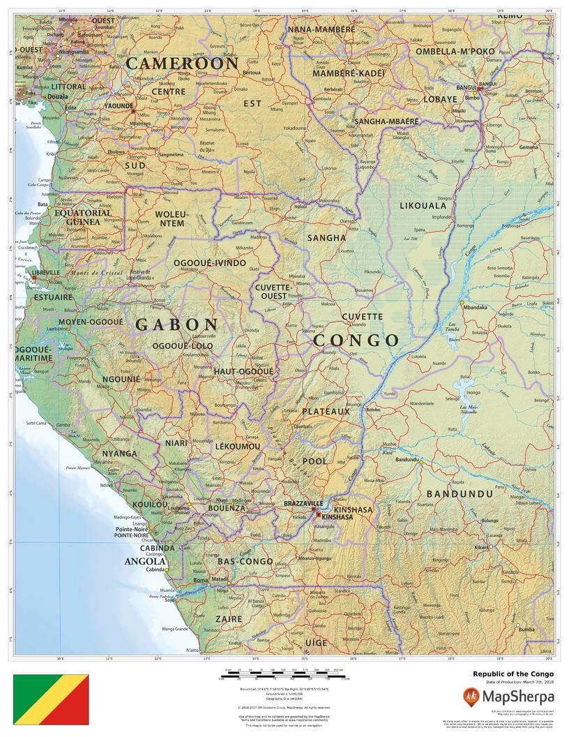
Experience the Republic of the Congo in elegant, wall-ready clarity. This large-format map blends clean political boundaries with beautiful physical cartography—from the Congo Basin and Sangha–Likouala wetlands to the Atlantic coastline at Pointe-Noire. Subtle relief shading and elevation colour-bands make landforms instantly legible, while cities, roads, borders, and waterways support teaching, planning, and display.
🗺️ Map Features
-
Physical + Political Coverage – National borders, departments (where shown), key cities/towns, and routes over a refined terrain base.
-
Relief Shading & Elevation Tints – Hypsometric colours and hillshading reveal plateaus, lowlands, and river plains at a glance.
-
Hydrology & Coastline – Clear depiction of the Congo, Ubangi, Sangha, Likouala-aux-Herbes, and Kouilou-Niari rivers, plus coastal context on the Atlantic.
-
Regional Orientation – Surrounding countries (Gabon, Cameroon, Central African Republic, DR Congo, Angola’s Cabinda) included for geographic continuity.
-
Wall-Optimised Cartography – Balanced label hierarchy and crisp symbology ensure clarity without clutter at typical viewing distances.
✨ Available Finishes
| Format | Description |
|---|---|
| 📜 Paper (160 gsm) | Heavyweight matte-coated paper—perfect for framing under glass. |
| 🧼 Laminated (Encapsulated) | Fully sealed in 80-micron gloss laminate—durable, wipe-clean, and annotation-friendly. |
| 🪵 Laminated with Wooden Hang Rails | Laminated map mounted with lacquered natural timber rails (top & bottom) and a hanging cord—ready to display. |
| 🖼️ Canvas (395 gsm) | HP Professional Matte Canvas printed with archival pigment-based inks—rich texture, fade-resistant, gallery-grade. |
| 🪵 Canvas with Wooden Hang Rails | Canvas finished with lacquered timber rails and a hanging cord—timeless, frame-free presentation. |
🔨 Hang-railed maps are made to order—please allow up to 10 working days for professional mounting.
📐 Specifications
| Feature | Detail |
|---|---|
| Title | Republic of the Congo Wall Map |
| Map Type | Physical / Political |
| Scale | 1:3,000,000 |
| Dimensions | 864 mm (W) × 1118 mm (H) |
| Orientation | Portrait |
| Materials | Paper, Laminated, Canvas, With or Without Timber Rails |
| Printing | Archival pigment-based inks, fade-resistant |
💡 Why You’ll Love It
-
At-a-glance terrain—see plateaus, floodplains, and coastal areas in elegant relief.
-
Rich river detail—track Congo Basin tributaries and wetlands with ease.
-
Clear political framing for classrooms, offices, and field planning.
-
Five premium finishes to match any space and usage.
-
Durable options (laminated/canvas) built for long-term, everyday use.
🚚 Delivery
-
Paper, Laminated & Canvas (rolled): Usually ships within 1–2 business days.
-
Hang-railed versions: Made to order; allow up to 10 working days.
-
Packaging: Securely protected to arrive in pristine condition.
Bring the Congo Basin’s landscapes and connections into focus. Choose your finish, hang with ease, and enjoy a map that’s both beautiful and deeply useful.
Original: $57.20
-65%$57.20
$20.02Product Information
Product Information
Shipping & Returns
Shipping & Returns
Description
Physical & Political Detail | Congo Basin Rivers | Premium Finishes
Experience the Republic of the Congo in elegant, wall-ready clarity. This large-format map blends clean political boundaries with beautiful physical cartography—from the Congo Basin and Sangha–Likouala wetlands to the Atlantic coastline at Pointe-Noire. Subtle relief shading and elevation colour-bands make landforms instantly legible, while cities, roads, borders, and waterways support teaching, planning, and display.
🗺️ Map Features
-
Physical + Political Coverage – National borders, departments (where shown), key cities/towns, and routes over a refined terrain base.
-
Relief Shading & Elevation Tints – Hypsometric colours and hillshading reveal plateaus, lowlands, and river plains at a glance.
-
Hydrology & Coastline – Clear depiction of the Congo, Ubangi, Sangha, Likouala-aux-Herbes, and Kouilou-Niari rivers, plus coastal context on the Atlantic.
-
Regional Orientation – Surrounding countries (Gabon, Cameroon, Central African Republic, DR Congo, Angola’s Cabinda) included for geographic continuity.
-
Wall-Optimised Cartography – Balanced label hierarchy and crisp symbology ensure clarity without clutter at typical viewing distances.
✨ Available Finishes
| Format | Description |
|---|---|
| 📜 Paper (160 gsm) | Heavyweight matte-coated paper—perfect for framing under glass. |
| 🧼 Laminated (Encapsulated) | Fully sealed in 80-micron gloss laminate—durable, wipe-clean, and annotation-friendly. |
| 🪵 Laminated with Wooden Hang Rails | Laminated map mounted with lacquered natural timber rails (top & bottom) and a hanging cord—ready to display. |
| 🖼️ Canvas (395 gsm) | HP Professional Matte Canvas printed with archival pigment-based inks—rich texture, fade-resistant, gallery-grade. |
| 🪵 Canvas with Wooden Hang Rails | Canvas finished with lacquered timber rails and a hanging cord—timeless, frame-free presentation. |
🔨 Hang-railed maps are made to order—please allow up to 10 working days for professional mounting.
📐 Specifications
| Feature | Detail |
|---|---|
| Title | Republic of the Congo Wall Map |
| Map Type | Physical / Political |
| Scale | 1:3,000,000 |
| Dimensions | 864 mm (W) × 1118 mm (H) |
| Orientation | Portrait |
| Materials | Paper, Laminated, Canvas, With or Without Timber Rails |
| Printing | Archival pigment-based inks, fade-resistant |
💡 Why You’ll Love It
-
At-a-glance terrain—see plateaus, floodplains, and coastal areas in elegant relief.
-
Rich river detail—track Congo Basin tributaries and wetlands with ease.
-
Clear political framing for classrooms, offices, and field planning.
-
Five premium finishes to match any space and usage.
-
Durable options (laminated/canvas) built for long-term, everyday use.
🚚 Delivery
-
Paper, Laminated & Canvas (rolled): Usually ships within 1–2 business days.
-
Hang-railed versions: Made to order; allow up to 10 working days.
-
Packaging: Securely protected to arrive in pristine condition.
Bring the Congo Basin’s landscapes and connections into focus. Choose your finish, hang with ease, and enjoy a map that’s both beautiful and deeply useful.


