Rottnest Island : “Wadjemup” — Daisy Bates Special Map (1929)
A Rare Cultural & Cartographic Record of Western Australia’s Iconic Island
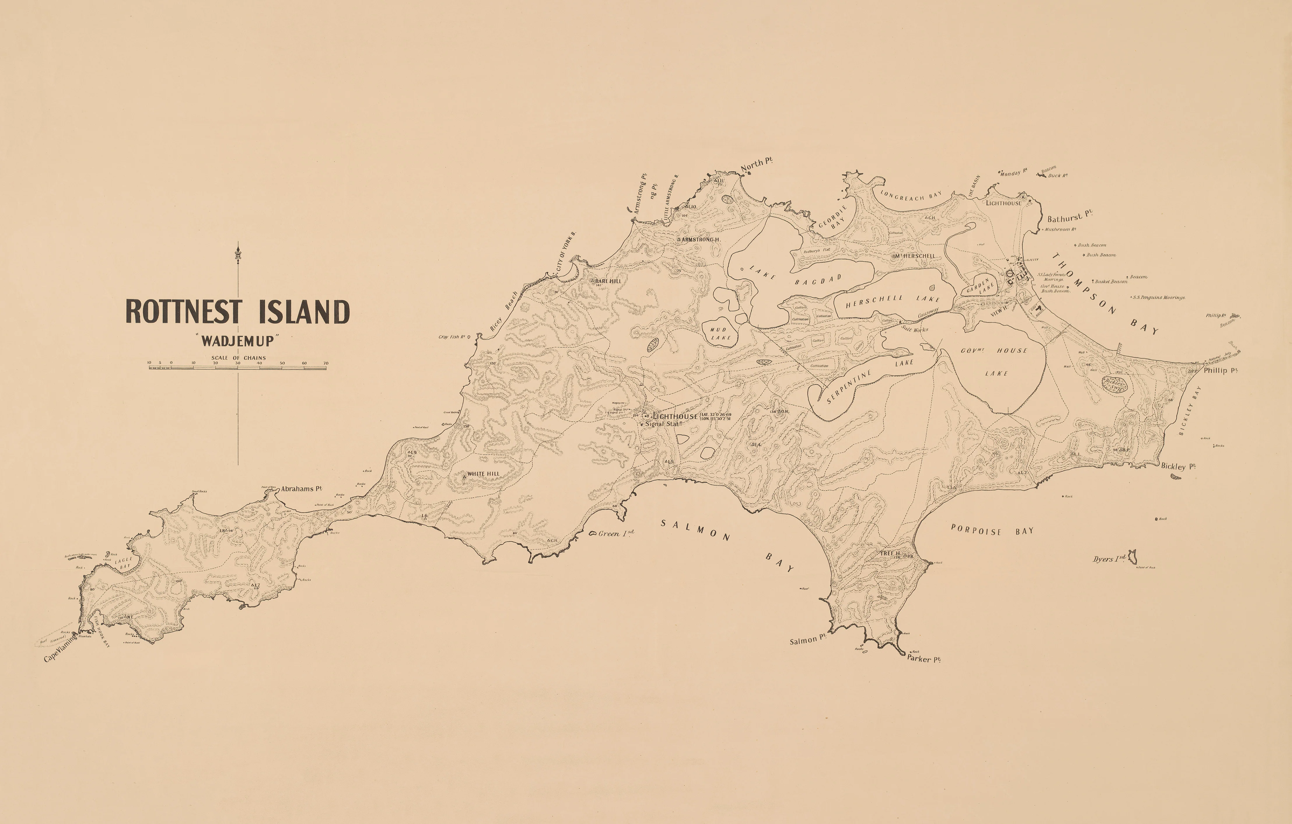
Step into the layered history of Rottnest Island—known for tens of thousands of years as Wadjemup—with this beautifully restored 1929 Daisy Bates Special Map. More than a simple geographic record, this map captures the island at a moment where Aboriginal heritage, colonial history, and early scientific observation intersect.
Rendered using traditional techniques of hachures and spot heights, the terrain comes alive with depth and texture—offering a tactile sense of elevation that modern mapping rarely achieves. It is a piece that invites both close study and quiet reflection.
⚓ A Window into Wadjemup’s Past
Created in 1929, this special map reflects the work and legacy of Daisy Bates—a complex and often debated figure in Australian history. Her documentation of Aboriginal culture and landscape provides context that goes beyond cartography.
Here, Wadjemup is not just an island—it is:
- A place of deep cultural significance to the Noongar people
- A site of colonial encounter and maritime activity
- A landscape shaped by wind, limestone, and isolation
The map’s detailed relief work—through hachures—gives the island a sculptural quality, while spot heights and coastal delineation guide the eye across bays, headlands, and inland rises.
🗺️ What You’ll See
- Full island coverage of Rottnest / Wadjemup with historic place naming
- Relief shown through hachures — a classic 19th–early 20th century technique
- Spot heights marking elevation points across the island
- Detailed shoreline and coastal features, including bays and headlands
- Early cartographic styling with balanced typography and fine linework
- A visual record that bridges scientific mapping and cultural documentation
🎨 Premium Finishes & Display Options
Printed using archival-grade materials and precision colour management, each finish is designed to enhance both the historical character and visual impact of this 1929 map.
Heavyweight Paper (160 gsm Matte)
Classic. Elegant. Frame-ready.
- Printed on premium 160 gsm archival matte paper for crisp detail and accurate tonal reproduction
- Smooth, non-reflective surface ensures excellent readability in all lighting conditions
- Designed for traditional framing under glass or archival storage
- Lightweight and versatile—ideal for collectors who prefer flexibility in presentation
💡 Best for: Heritage interiors, studies, collectors, and those wanting a refined framed look
Laminated (True Encapsulation — 2 × 80 Micron Gloss)
Durable. Practical. Built to last.
- Fully sealed using true encapsulation (2 × 80-micron gloss laminate)
- Protects against moisture, dust, tearing, and UV exposure
- Wipe-clean surface allows for whiteboard marker use and map annotations
- Slight gloss enhances contrast and colour depth while maintaining clarity
💡 Best for: Offices, classrooms, marine environments, or high-traffic spaces
Laminated + Timber Hang Rails
Ready-to-hang. Clean. Architectural presence.
- Professionally mounted with natural lacquered timber rails (top and bottom)
- Includes fitted hanging cord for immediate installation—no framing required
- Bottom rail adds weight, keeping the map flat and perfectly presented
- Combines durability of lamination with a warm, contemporary display finish
💡 Best for: Boardrooms, offices, studios, and statement wall displays
Note: Please allow up to 10 working days for hang-railed versions.
Archival Canvas (395 gsm HP Professional Matte)
Textured. Museum-grade. Timeless.
- Printed on 395 gsm HP Professional Matte Canvas for a rich, tactile finish
- Subtle canvas weave adds depth and character, echoing historic maproom displays
- Produced using pigment-based, fade-resistant inks for long-term colour stability
- Glare-free surface enhances visibility and softens the overall aesthetic
💡 Best for: Living rooms, galleries, heritage interiors, and design-focused spaces
Canvas + Timber Hang Rails
Gallery-ready. Elevated. Effortlessly striking.
- Combines premium canvas printing with natural timber hanging rails
- Creates a frame-free, contemporary presentation with strong visual impact
- Adds weight and structure, ensuring the canvas hangs cleanly and evenly
- A refined alternative to framing—simple, elegant, and highly effective
💡 Best for: Feature walls, executive spaces, curated interiors, and premium gifting
Note: Please allow up to 10 working days for hang-railed versions.
📐 Specifications
| Attribute | Detail |
|---|---|
| Title | Rottnest Island : “Wadjemup” — Daisy Bates Special Map |
| Published | 1929 |
| Cartographer / Attribution | Daisy Bates |
| Geographic Location | Rottnest Island (Wadjemup), Western Australia |
| Relief Representation | Hachures and spot heights |
| Print Size | 900 mm (W) × 575 mm (H) |
| Orientation | Landscape |
| Available Finishes | Paper (160 gsm), Laminated (2 × 80 micron gloss), Canvas (395 gsm HP Professional Matte) |
| Optional Hang Rails | Natural timber, lacquered (allow up to 10 working days) |
| Inks | Pigment-based, fade-resistant |
| Origin | Printed in Australia |
✅ Why Choose This Map?
| Feature | Benefit |
|---|---|
| Authentic 1929 issue | A genuine historical snapshot of Rottnest Island |
| Daisy Bates provenance | Links to a significant historical figure |
| Classic relief style | Hachures create visual depth and texture |
| Cultural significance | Connects Aboriginal heritage with mapped landscape |
| Premium materials | Built for lasting display |
🎯 Perfect For
- Western Australian history enthusiasts
- Cartography collectors
- Educators and cultural institutions
- Interior designers
- Meaningful, locally significant gifting
🤝 Our Commitment
Every map is printed in Australia using premium materials and colour-managed processes to ensure clarity, depth, and longevity. Each piece is carefully checked and packed before dispatch.
Bring the story of Wadjemup into your space—a place of deep time, cultural meaning, and enduring beauty—captured in one remarkable map.
Original: $50.05
-65%$50.05
$17.52Product Information
Product Information
Shipping & Returns
Shipping & Returns
Description
A Rare Cultural & Cartographic Record of Western Australia’s Iconic Island
Step into the layered history of Rottnest Island—known for tens of thousands of years as Wadjemup—with this beautifully restored 1929 Daisy Bates Special Map. More than a simple geographic record, this map captures the island at a moment where Aboriginal heritage, colonial history, and early scientific observation intersect.
Rendered using traditional techniques of hachures and spot heights, the terrain comes alive with depth and texture—offering a tactile sense of elevation that modern mapping rarely achieves. It is a piece that invites both close study and quiet reflection.
⚓ A Window into Wadjemup’s Past
Created in 1929, this special map reflects the work and legacy of Daisy Bates—a complex and often debated figure in Australian history. Her documentation of Aboriginal culture and landscape provides context that goes beyond cartography.
Here, Wadjemup is not just an island—it is:
- A place of deep cultural significance to the Noongar people
- A site of colonial encounter and maritime activity
- A landscape shaped by wind, limestone, and isolation
The map’s detailed relief work—through hachures—gives the island a sculptural quality, while spot heights and coastal delineation guide the eye across bays, headlands, and inland rises.
🗺️ What You’ll See
- Full island coverage of Rottnest / Wadjemup with historic place naming
- Relief shown through hachures — a classic 19th–early 20th century technique
- Spot heights marking elevation points across the island
- Detailed shoreline and coastal features, including bays and headlands
- Early cartographic styling with balanced typography and fine linework
- A visual record that bridges scientific mapping and cultural documentation
🎨 Premium Finishes & Display Options
Printed using archival-grade materials and precision colour management, each finish is designed to enhance both the historical character and visual impact of this 1929 map.
Heavyweight Paper (160 gsm Matte)
Classic. Elegant. Frame-ready.
- Printed on premium 160 gsm archival matte paper for crisp detail and accurate tonal reproduction
- Smooth, non-reflective surface ensures excellent readability in all lighting conditions
- Designed for traditional framing under glass or archival storage
- Lightweight and versatile—ideal for collectors who prefer flexibility in presentation
💡 Best for: Heritage interiors, studies, collectors, and those wanting a refined framed look
Laminated (True Encapsulation — 2 × 80 Micron Gloss)
Durable. Practical. Built to last.
- Fully sealed using true encapsulation (2 × 80-micron gloss laminate)
- Protects against moisture, dust, tearing, and UV exposure
- Wipe-clean surface allows for whiteboard marker use and map annotations
- Slight gloss enhances contrast and colour depth while maintaining clarity
💡 Best for: Offices, classrooms, marine environments, or high-traffic spaces
Laminated + Timber Hang Rails
Ready-to-hang. Clean. Architectural presence.
- Professionally mounted with natural lacquered timber rails (top and bottom)
- Includes fitted hanging cord for immediate installation—no framing required
- Bottom rail adds weight, keeping the map flat and perfectly presented
- Combines durability of lamination with a warm, contemporary display finish
💡 Best for: Boardrooms, offices, studios, and statement wall displays
Note: Please allow up to 10 working days for hang-railed versions.
Archival Canvas (395 gsm HP Professional Matte)
Textured. Museum-grade. Timeless.
- Printed on 395 gsm HP Professional Matte Canvas for a rich, tactile finish
- Subtle canvas weave adds depth and character, echoing historic maproom displays
- Produced using pigment-based, fade-resistant inks for long-term colour stability
- Glare-free surface enhances visibility and softens the overall aesthetic
💡 Best for: Living rooms, galleries, heritage interiors, and design-focused spaces
Canvas + Timber Hang Rails
Gallery-ready. Elevated. Effortlessly striking.
- Combines premium canvas printing with natural timber hanging rails
- Creates a frame-free, contemporary presentation with strong visual impact
- Adds weight and structure, ensuring the canvas hangs cleanly and evenly
- A refined alternative to framing—simple, elegant, and highly effective
💡 Best for: Feature walls, executive spaces, curated interiors, and premium gifting
Note: Please allow up to 10 working days for hang-railed versions.
📐 Specifications
| Attribute | Detail |
|---|---|
| Title | Rottnest Island : “Wadjemup” — Daisy Bates Special Map |
| Published | 1929 |
| Cartographer / Attribution | Daisy Bates |
| Geographic Location | Rottnest Island (Wadjemup), Western Australia |
| Relief Representation | Hachures and spot heights |
| Print Size | 900 mm (W) × 575 mm (H) |
| Orientation | Landscape |
| Available Finishes | Paper (160 gsm), Laminated (2 × 80 micron gloss), Canvas (395 gsm HP Professional Matte) |
| Optional Hang Rails | Natural timber, lacquered (allow up to 10 working days) |
| Inks | Pigment-based, fade-resistant |
| Origin | Printed in Australia |
✅ Why Choose This Map?
| Feature | Benefit |
|---|---|
| Authentic 1929 issue | A genuine historical snapshot of Rottnest Island |
| Daisy Bates provenance | Links to a significant historical figure |
| Classic relief style | Hachures create visual depth and texture |
| Cultural significance | Connects Aboriginal heritage with mapped landscape |
| Premium materials | Built for lasting display |
🎯 Perfect For
- Western Australian history enthusiasts
- Cartography collectors
- Educators and cultural institutions
- Interior designers
- Meaningful, locally significant gifting
🤝 Our Commitment
Every map is printed in Australia using premium materials and colour-managed processes to ensure clarity, depth, and longevity. Each piece is carefully checked and packed before dispatch.
Bring the story of Wadjemup into your space—a place of deep time, cultural meaning, and enduring beauty—captured in one remarkable map.


