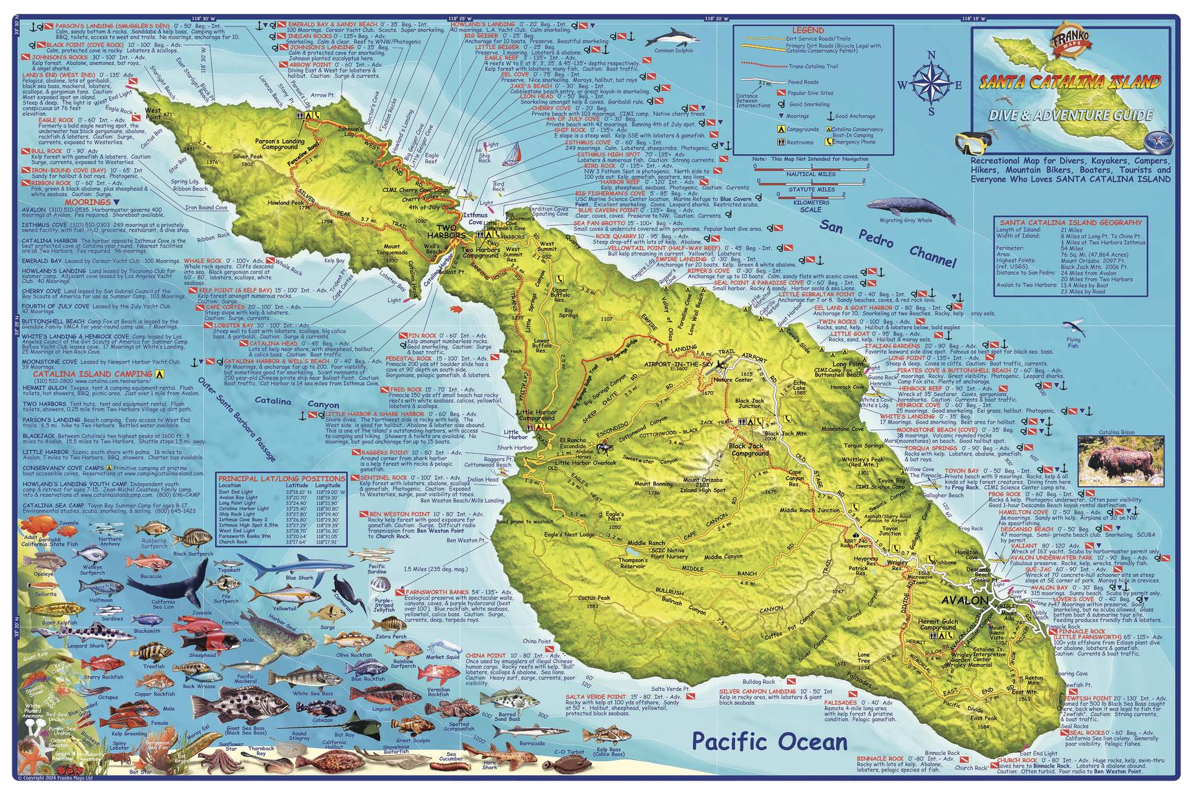
Santa Catalina Island Wall Map by Franko
Santa Catalina Island Wall Map — Franko’s Maps (2024) — 914 × 610 mm
Topographic Relief | Dive & Snorkel Sites | Trails, Moorings & Campgrounds | Premium Finishes
Bring Catalina to your wall with Franko’s beautifully rendered shaded-relief topographic map of Santa Catalina Island, California. Perfect for divers, hikers, paddlers, and island lovers, it locates dirt roads, the Trans-Catalina Trail, dive & snorkel sites, moorings, campgrounds, and anchorages—all set against crisp terrain shading and coastal bathymetry. Lively illustrations of local fish and marine life add colour, character, and quick ID at a glance.
🗺️ Highlights at a Glance
-
Island at-a-glance — Clear relief shading, coastline detail, coves, points, and harbours.
-
Adventure ready — Trans-Catalina Trail trace, dirt roads, access points, and camps.
-
On the water — Dive/snorkel sites with names & brief notes, moorings and anchorages.
-
Marine life panel — Franko’s colourful illustrations of Catalina fishes and ocean creatures.
-
Wall-readable design — Clean labelling and a balanced cartographic palette for home, office, clubhouse, or classroom.
(This is a wall/plan reference; always consult current local notices, charts, and operators when on the water or trail.)
✨ Premium Finishes (choose your display)
| Format | Description |
|---|---|
| 📜 Paper (160 gsm matte) | Archival, smooth finish—ideal for framing under glass. |
| 🧼 Laminated (True Encapsulation) | 2 × 80-micron gloss, edge-sealed; durable, wipe-clean, perfect for planning. |
| 🖼️ Canvas (395 gsm HP Professional Matte) | Gallery-grade texture; pigment-based, fade-resistant inks for long life. |
| 🪵 Laminated + Timber Hang Rails | Natural timber rails (top/bottom) with fitted cord—ready to hang. Allow up to 10 working days. |
| 🪵 Canvas + Timber Hang Rails | Canvas finished with lacquered natural timber rails—frameless elegance. Allow up to 10 working days. |
📐 Specifications
| Feature | Detail |
|---|---|
| Title | Santa Catalina Island Wall Map — Franko’s Maps |
| Publisher/Cartographer | Franko’s Maps |
| Edition / Year | 2024 |
| Coverage | Santa Catalina Island (California), with dive/snorkel sites, moorings, campgrounds, anchorages & Trans-Catalina Trail |
| Map Type | Shaded-relief topographic & recreation reference |
| Dimensions | 914 mm (W) × 610 mm (H) |
| Finishes | Paper, Laminated (2×80-micron), Canvas (395 gsm), optional timber hang rails |
| Printing | Archival pigment inks for long-term colour stability |
| Origin | Printed in Australia |
🎯 Ideal For
-
Divers & snorkellers planning Catalina reef and kelp-forest sessions.
-
Hikers & campers mapping the Trans-Catalina Trail and campground logistics.
-
Yacht clubs & marinas highlighting moorings and anchorages at a glance.
-
Home, office & classrooms seeking a vibrant, accurate Catalina centrepiece.
🤝 Our Commitment
-
Local craftsmanship: Designed, printed, and finished in Australia.
-
Premium materials: Archival HP pigment inks, professional laminates, natural timber rails.
-
Colour-managed clarity: Wall-readable labelling and consistent cartography at statement scale.
-
Built to last: Durable finishes to extend service life and reduce waste.
-
Packed with care: Every map is hand-checked and shipped to arrive clean and display-ready.
🚚 Shipping & Lead Time
-
Paper / Laminated / Canvas (rolled): Usually ships within 1–2 business days.
-
Hang-railed maps: Custom mounted—please allow up to 10 working days.
Celebrate California’s island playground—Catalina, the trail, the coves, and the kelp forests—on your wall. Add to cart and start planning your next crossing.
Original: $50.05
-65%$50.05
$17.52Product Information
Product Information
Shipping & Returns
Shipping & Returns
Description
Santa Catalina Island Wall Map — Franko’s Maps (2024) — 914 × 610 mm
Topographic Relief | Dive & Snorkel Sites | Trails, Moorings & Campgrounds | Premium Finishes
Bring Catalina to your wall with Franko’s beautifully rendered shaded-relief topographic map of Santa Catalina Island, California. Perfect for divers, hikers, paddlers, and island lovers, it locates dirt roads, the Trans-Catalina Trail, dive & snorkel sites, moorings, campgrounds, and anchorages—all set against crisp terrain shading and coastal bathymetry. Lively illustrations of local fish and marine life add colour, character, and quick ID at a glance.
🗺️ Highlights at a Glance
-
Island at-a-glance — Clear relief shading, coastline detail, coves, points, and harbours.
-
Adventure ready — Trans-Catalina Trail trace, dirt roads, access points, and camps.
-
On the water — Dive/snorkel sites with names & brief notes, moorings and anchorages.
-
Marine life panel — Franko’s colourful illustrations of Catalina fishes and ocean creatures.
-
Wall-readable design — Clean labelling and a balanced cartographic palette for home, office, clubhouse, or classroom.
(This is a wall/plan reference; always consult current local notices, charts, and operators when on the water or trail.)
✨ Premium Finishes (choose your display)
| Format | Description |
|---|---|
| 📜 Paper (160 gsm matte) | Archival, smooth finish—ideal for framing under glass. |
| 🧼 Laminated (True Encapsulation) | 2 × 80-micron gloss, edge-sealed; durable, wipe-clean, perfect for planning. |
| 🖼️ Canvas (395 gsm HP Professional Matte) | Gallery-grade texture; pigment-based, fade-resistant inks for long life. |
| 🪵 Laminated + Timber Hang Rails | Natural timber rails (top/bottom) with fitted cord—ready to hang. Allow up to 10 working days. |
| 🪵 Canvas + Timber Hang Rails | Canvas finished with lacquered natural timber rails—frameless elegance. Allow up to 10 working days. |
📐 Specifications
| Feature | Detail |
|---|---|
| Title | Santa Catalina Island Wall Map — Franko’s Maps |
| Publisher/Cartographer | Franko’s Maps |
| Edition / Year | 2024 |
| Coverage | Santa Catalina Island (California), with dive/snorkel sites, moorings, campgrounds, anchorages & Trans-Catalina Trail |
| Map Type | Shaded-relief topographic & recreation reference |
| Dimensions | 914 mm (W) × 610 mm (H) |
| Finishes | Paper, Laminated (2×80-micron), Canvas (395 gsm), optional timber hang rails |
| Printing | Archival pigment inks for long-term colour stability |
| Origin | Printed in Australia |
🎯 Ideal For
-
Divers & snorkellers planning Catalina reef and kelp-forest sessions.
-
Hikers & campers mapping the Trans-Catalina Trail and campground logistics.
-
Yacht clubs & marinas highlighting moorings and anchorages at a glance.
-
Home, office & classrooms seeking a vibrant, accurate Catalina centrepiece.
🤝 Our Commitment
-
Local craftsmanship: Designed, printed, and finished in Australia.
-
Premium materials: Archival HP pigment inks, professional laminates, natural timber rails.
-
Colour-managed clarity: Wall-readable labelling and consistent cartography at statement scale.
-
Built to last: Durable finishes to extend service life and reduce waste.
-
Packed with care: Every map is hand-checked and shipped to arrive clean and display-ready.
🚚 Shipping & Lead Time
-
Paper / Laminated / Canvas (rolled): Usually ships within 1–2 business days.
-
Hang-railed maps: Custom mounted—please allow up to 10 working days.
Celebrate California’s island playground—Catalina, the trail, the coves, and the kelp forests—on your wall. Add to cart and start planning your next crossing.