South Africa and Madagascar Wall Map by Batholomew & Son LTD 1952
South Africa & Madagascar — Wall Map by J. Bartholomew & Son Ltd (1952)
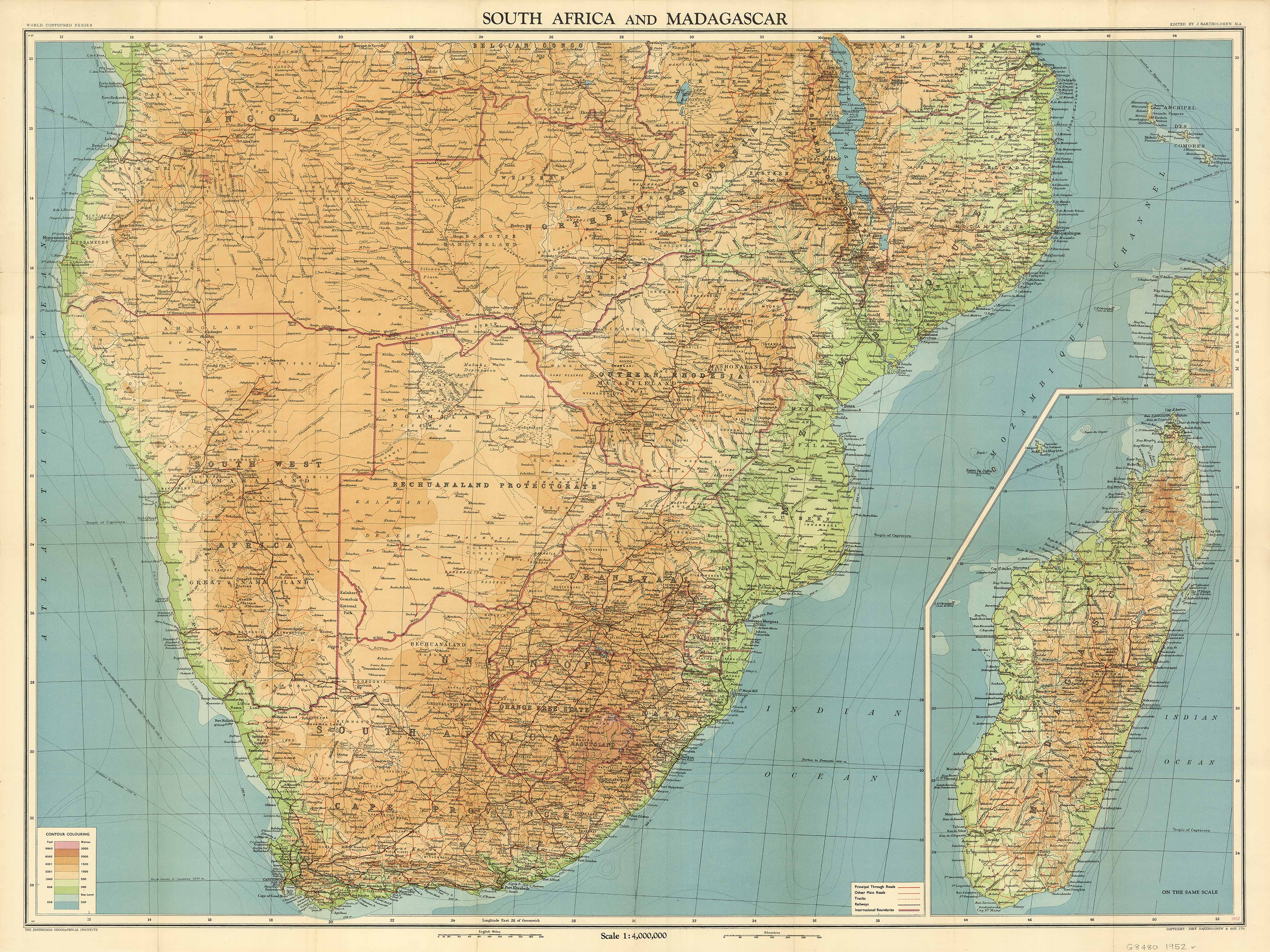
Ocean-lipped capes, escarpments falling to savannah, and island highlands rising from deep water—this 1952 classic from J. Bartholomew & Son Ltd., Edinburgh gathers South Africa and Madagascar into one poised, topographic portrait. Fine hill-shading, disciplined place-naming and clear hydrography turn a complex region into calm, legible geography. Part atlas plate, part showcase, it brings a mid-century vision of the subcontinent to your wall—authoritative, elegant, enduring.
Why it captivates
-
Topographic clarity — meticulous hill-shading and relief make ranges, plateaus and coastal shelves read at a glance.
-
Dense, readable naming — towns, rivers, capes and provinces arranged in a balanced, room-length hierarchy.
-
Atlas pedigree — produced by J. Bartholomew & Son Ltd and edited by J. Bartholomew, M.A., leaders of British cartography.
-
Scholarly & beautiful — restrained colour and precise draughting that reward both overview and close study.
What you’ll see
-
South Africa & Madagascar on one sheet, with adjacent waters and regional context.
-
Physical features & hydrography—escarpments, ranges, river systems and coastlines rendered with classic Bartholomew shading.
-
Transport & settlement pattern—principal roads/rails and a disciplined lattice of place names.
-
Period finish preserved—titlework, neatline and calm typography.
A richer historical frame
By 1952, Bartholomew’s Edinburgh studio was at full stride—combining accurate survey sources with a house style famous for hill-shading and clean, modern lettering. This sheet captures that synthesis: evidence arranged with care, presenting a continent’s southern rim and its great island neighbour with clarity that still feels fresh.
Choose your finish
Heavyweight Paper (160 gsm matte)
Best for: framing under glass in studies and living spaces
Look & feel: non-glare matte that preserves fine linework and small labels
Laminated (true encapsulation)
Best for: classrooms, libraries, offices and shared spaces
Build: sealed edge-to-edge between two 80-micron gloss sheets
Benefit: wipe-clean, durable, moisture-resistant
Laminated + Timber Hang Rails (Ready to hang)
What you get: encapsulated print plus natural lacquered timber rails top & bottom with a discreet hanging cord
Where it shines: foyers, council buildings, museums—polished look with everyday toughness
Install: arrives ready to hang (just add a wall hook)
Lead time: please allow up to 10 working days for professional rail mounting
Archival Canvas (395 gsm HP Professional Matte)
Best for: premium interiors, boardrooms and galleries
Print system: pigment-based, fade-resistant inks for long display life
Presence: textured surface adds warmth and museum-style depth
Canvas + Timber Hang Rails (Gallery-ready)
What you get: canvas fitted with natural timber rails top & bottom, matching cord
Where it shines: statement walls, curated cartography displays
Install: ready to hang; single-hook friendly
Lead time: please allow up to 10 working days for rail mounting
Sizes (W × H)
-
1000 × 700 mm — generous wall presence with strong regional readability
-
1300 × 1000 mm — commanding centrepiece for larger rooms and public foyers
At-a-glance materials
| Option | Best for | Key benefits |
|---|---|---|
| Paper (160 gsm) | Framing under glass | Matte clarity; crisp shaded relief |
| Laminated (encapsulated) | Busy/shared spaces | Wipeable; tough; edge-to-edge protection |
| Laminated + Rails | Ready-to-hang public display | Professional mount; easy install; durable |
| Canvas (395 gsm) | Premium display | Archival inks; textured depth; gallery appeal |
| Canvas + Rails | Gallery-ready feature | Period-true presentation; simple hanging |
Styling ideas
-
Study or library: frame the paper edition; add a brass picture light for warm, scholarly tone.
-
Museum or council foyer: choose Laminated + Rails for a polished, robust display.
-
Boardroom or lounge: canvas with rails above timber cabinetry for quiet authority.
-
Travel wall: pair with a caption card noting family places or routes.
Specifications
| Detail | Description |
|---|---|
| Title | South Africa & Madagascar — Wall Map |
| Edition | 1952 |
| Cartographer/Publisher | J. Bartholomew & Son Ltd., Edinburgh |
| Editor | J. Bartholomew, M.A. |
| Region | South Africa and Madagascar (with surrounding context) |
| Type | Mid-century topographic/physical map |
| Content Highlights | Place names; physical features; shaded relief; hydrography; transport pattern; period lettering & neatline |
| Finishes | Paper; Laminated (encapsulated); Laminated + Timber Rails; Canvas; Canvas + Timber Rails |
| Lead Time (Rails) | Up to 10 working days (laminated or canvas with rails) |
| Orientation | Landscape |
| Sizes | 1000 × 700 mm; 1300 × 1000 mm |
| Production | Made in Australia |
Who it’s for
-
Geographers, educators & libraries teaching African physical and human landscapes
-
Collectors of classic British atlas cartography
-
Interior designers seeking refined mid-century mapping with global scope
Claim your wall. Choose Paper for crisp, frame-ready clarity. Go Laminated + Timber Rails for tough, ready-to-hang polish. Step up to Archival Canvas + Timber Hang Rails for gallery weight. Printed in Australia with pigment-based, fade-resistant inks.
Original: $42.89
-65%$42.89
$15.01Product Information
Product Information
Shipping & Returns
Shipping & Returns
Description
South Africa & Madagascar — Wall Map by J. Bartholomew & Son Ltd (1952)
Ocean-lipped capes, escarpments falling to savannah, and island highlands rising from deep water—this 1952 classic from J. Bartholomew & Son Ltd., Edinburgh gathers South Africa and Madagascar into one poised, topographic portrait. Fine hill-shading, disciplined place-naming and clear hydrography turn a complex region into calm, legible geography. Part atlas plate, part showcase, it brings a mid-century vision of the subcontinent to your wall—authoritative, elegant, enduring.
Why it captivates
-
Topographic clarity — meticulous hill-shading and relief make ranges, plateaus and coastal shelves read at a glance.
-
Dense, readable naming — towns, rivers, capes and provinces arranged in a balanced, room-length hierarchy.
-
Atlas pedigree — produced by J. Bartholomew & Son Ltd and edited by J. Bartholomew, M.A., leaders of British cartography.
-
Scholarly & beautiful — restrained colour and precise draughting that reward both overview and close study.
What you’ll see
-
South Africa & Madagascar on one sheet, with adjacent waters and regional context.
-
Physical features & hydrography—escarpments, ranges, river systems and coastlines rendered with classic Bartholomew shading.
-
Transport & settlement pattern—principal roads/rails and a disciplined lattice of place names.
-
Period finish preserved—titlework, neatline and calm typography.
A richer historical frame
By 1952, Bartholomew’s Edinburgh studio was at full stride—combining accurate survey sources with a house style famous for hill-shading and clean, modern lettering. This sheet captures that synthesis: evidence arranged with care, presenting a continent’s southern rim and its great island neighbour with clarity that still feels fresh.
Choose your finish
Heavyweight Paper (160 gsm matte)
Best for: framing under glass in studies and living spaces
Look & feel: non-glare matte that preserves fine linework and small labels
Laminated (true encapsulation)
Best for: classrooms, libraries, offices and shared spaces
Build: sealed edge-to-edge between two 80-micron gloss sheets
Benefit: wipe-clean, durable, moisture-resistant
Laminated + Timber Hang Rails (Ready to hang)
What you get: encapsulated print plus natural lacquered timber rails top & bottom with a discreet hanging cord
Where it shines: foyers, council buildings, museums—polished look with everyday toughness
Install: arrives ready to hang (just add a wall hook)
Lead time: please allow up to 10 working days for professional rail mounting
Archival Canvas (395 gsm HP Professional Matte)
Best for: premium interiors, boardrooms and galleries
Print system: pigment-based, fade-resistant inks for long display life
Presence: textured surface adds warmth and museum-style depth
Canvas + Timber Hang Rails (Gallery-ready)
What you get: canvas fitted with natural timber rails top & bottom, matching cord
Where it shines: statement walls, curated cartography displays
Install: ready to hang; single-hook friendly
Lead time: please allow up to 10 working days for rail mounting
Sizes (W × H)
-
1000 × 700 mm — generous wall presence with strong regional readability
-
1300 × 1000 mm — commanding centrepiece for larger rooms and public foyers
At-a-glance materials
| Option | Best for | Key benefits |
|---|---|---|
| Paper (160 gsm) | Framing under glass | Matte clarity; crisp shaded relief |
| Laminated (encapsulated) | Busy/shared spaces | Wipeable; tough; edge-to-edge protection |
| Laminated + Rails | Ready-to-hang public display | Professional mount; easy install; durable |
| Canvas (395 gsm) | Premium display | Archival inks; textured depth; gallery appeal |
| Canvas + Rails | Gallery-ready feature | Period-true presentation; simple hanging |
Styling ideas
-
Study or library: frame the paper edition; add a brass picture light for warm, scholarly tone.
-
Museum or council foyer: choose Laminated + Rails for a polished, robust display.
-
Boardroom or lounge: canvas with rails above timber cabinetry for quiet authority.
-
Travel wall: pair with a caption card noting family places or routes.
Specifications
| Detail | Description |
|---|---|
| Title | South Africa & Madagascar — Wall Map |
| Edition | 1952 |
| Cartographer/Publisher | J. Bartholomew & Son Ltd., Edinburgh |
| Editor | J. Bartholomew, M.A. |
| Region | South Africa and Madagascar (with surrounding context) |
| Type | Mid-century topographic/physical map |
| Content Highlights | Place names; physical features; shaded relief; hydrography; transport pattern; period lettering & neatline |
| Finishes | Paper; Laminated (encapsulated); Laminated + Timber Rails; Canvas; Canvas + Timber Rails |
| Lead Time (Rails) | Up to 10 working days (laminated or canvas with rails) |
| Orientation | Landscape |
| Sizes | 1000 × 700 mm; 1300 × 1000 mm |
| Production | Made in Australia |
Who it’s for
-
Geographers, educators & libraries teaching African physical and human landscapes
-
Collectors of classic British atlas cartography
-
Interior designers seeking refined mid-century mapping with global scope
Claim your wall. Choose Paper for crisp, frame-ready clarity. Go Laminated + Timber Rails for tough, ready-to-hang polish. Step up to Archival Canvas + Timber Hang Rails for gallery weight. Printed in Australia with pigment-based, fade-resistant inks.


