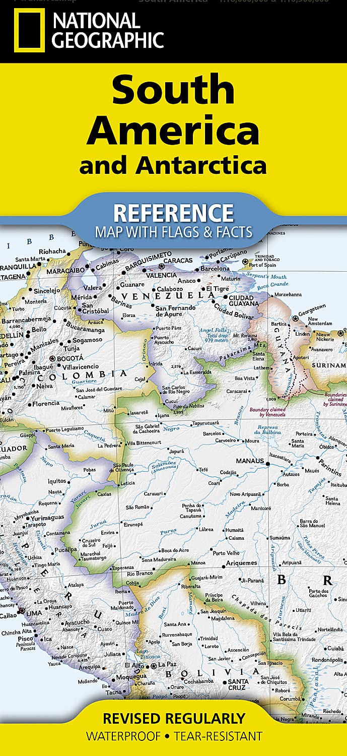
South America and Antarctica Folded Map
Waterproof • Tear-Resistant • Political + Physical Mapping • Education-Ready Reference
From the steamy expanse of the Amazon to the frozen silence of Antarctica, the South America & Antarctica Folded Map (Flags & Facts Edition) by National Geographic delivers a rare, sweeping view of two of the planet’s most extraordinary regions — brought together in one authoritative, beautifully balanced reference map.
This is a map that does more than show where things are. It explains how landscapes are formed, how nations are organised, and how the Southern Hemisphere connects as a whole — making it equally powerful for classrooms, planning desks, and curious minds.
🌎 Two Extremes of the Earth — One Unified Map
This map captures a remarkable geographic contrast:
South America
- Home to the Amazon Rainforest, the largest tropical forest on Earth
- The Andes Mountains, the longest continental mountain range
- Vast river systems, plains, and high-altitude plateaus
- A continent rich in biodiversity, culture, and history
Antarctica
- The coldest, driest, and most remote continent
- Covered by ice sheets holding the majority of Earth’s fresh water
- A global centre for climate science and research
- A land with no permanent population, governed by international agreement
Together, these two regions create a compelling narrative — from lush equatorial ecosystems to polar ice sheets, all within a single visual framework.
🗺️ Dual Mapping System — See the Full Picture
The primary map side uses a combined political and physical mapping approach, allowing you to understand both human and natural geography simultaneously.
Political Features
- Clearly defined country boundaries
- Capitals and major cities
- National borders and neighbouring regions
- Key populated areas and infrastructure
Physical Features
- Major mountain systems (including the Andes)
- River networks (Amazon, Paraná, Orinoco)
- Lakes, plains, deserts, and coastlines
- Elevation shading to visualise terrain
This dual-layer design gives you a complete understanding of how geography and civilisation interact.
🧭 Flags & Facts — A Deeper Layer of Understanding
Flip the map and you’ll find the Flags & Facts panel, which transforms the map into a powerful educational resource.
Includes:
- A combined political and physical map of Antarctica
- National flags of South American countries
- Key statistics and cultural information
- Geographic summaries that add context to the map
This section helps bridge the gap between visual mapping and real-world understanding, making it ideal for learning environments.
🌍 Designed for Clarity — Even at High Detail
National Geographic maps are renowned for their precision and legibility, and this edition is no exception.
Highlights:
- Hundreds of place names, carefully positioned to avoid clutter
- Clear typographic hierarchy for easy reading
- Balanced colour palette separating physical and political data
- Inclusion of adjacent regions to provide geographic context
Even densely populated areas remain clear and easy to interpret, making the map suitable for both close study and wall display.
📚 A Map That Teaches as You Explore
This is not just a reference — it’s a learning tool.
With this map, you can:
- Trace the path of major rivers across continents
- Understand how mountain ranges influence climate and settlement
- Compare political boundaries with natural geography
- Explore how South America connects to Antarctica geographically
It’s ideal for students, educators, and lifelong learners who want more than just surface-level geography.
🏫 Perfect for Home, Classroom & Display
This map works equally well in:
- Classrooms and lecture spaces
- Offices and planning rooms
- Study areas and libraries
- Family homes and learning environments
Its combination of clarity, durability, and educational depth makes it a long-term reference piece.
💪 Built to Last — National Geographic Quality
Printed on durable synthetic material, this map is designed for real use:
- 💧 Waterproof — resists spills and humidity
- 💪 Tear-resistant — stands up to frequent handling
- 🔁 Long-lasting — ideal for repeated folding and unfolding
Unlike traditional paper maps, it maintains its integrity over time — even in demanding environments.
🌏 Why This Map Stands Out
- Combines two continents in one cohesive view
- Integrates political and physical mapping seamlessly
- Includes Flags & Facts educational content
- Maintains exceptional clarity at high detail levels
- Built for durability and long-term use
- Produced by one of the world’s most trusted cartographic authorities
📐 Specifications
| Feature | Detail |
|---|---|
| Title | South America & Antarctica (Flags & Facts) |
| Publisher | National Geographic Maps |
| Format | Folded reference map |
| Material | Waterproof, tear-resistant synthetic paper |
| Flat Size | 18.5" × 25.25" (approx. 470 × 640 mm) |
| Folded Size | 4.25" × 9.25" (approx. 108 × 235 mm) |
| ISBN | 9781566959346 |
| Coverage | South America & Antarctica |
| Edition | Recent edition |
🎯 Who It’s For
Perfect for:
- Students and educators
- Travellers planning South American journeys
- Geography enthusiasts and collectors
- Anyone fascinated by Antarctica and polar regions
- Homes and offices needing a reliable reference map
✨ A Map of Contrast, Scale & Perspective
Few maps capture such dramatic contrast — from the dense green canopy of the Amazon to the vast white silence of Antarctica.
This map doesn’t just show geography — it reveals the scale, diversity, and interconnectedness of our planet.
A durable, educational, and visually striking map — ready for study, display, or exploration planning.
From rainforest to ice sheet — see the Southern Hemisphere in full.
Product Information
Product Information
Shipping & Returns
Shipping & Returns
Description
Waterproof • Tear-Resistant • Political + Physical Mapping • Education-Ready Reference
From the steamy expanse of the Amazon to the frozen silence of Antarctica, the South America & Antarctica Folded Map (Flags & Facts Edition) by National Geographic delivers a rare, sweeping view of two of the planet’s most extraordinary regions — brought together in one authoritative, beautifully balanced reference map.
This is a map that does more than show where things are. It explains how landscapes are formed, how nations are organised, and how the Southern Hemisphere connects as a whole — making it equally powerful for classrooms, planning desks, and curious minds.
🌎 Two Extremes of the Earth — One Unified Map
This map captures a remarkable geographic contrast:
South America
- Home to the Amazon Rainforest, the largest tropical forest on Earth
- The Andes Mountains, the longest continental mountain range
- Vast river systems, plains, and high-altitude plateaus
- A continent rich in biodiversity, culture, and history
Antarctica
- The coldest, driest, and most remote continent
- Covered by ice sheets holding the majority of Earth’s fresh water
- A global centre for climate science and research
- A land with no permanent population, governed by international agreement
Together, these two regions create a compelling narrative — from lush equatorial ecosystems to polar ice sheets, all within a single visual framework.
🗺️ Dual Mapping System — See the Full Picture
The primary map side uses a combined political and physical mapping approach, allowing you to understand both human and natural geography simultaneously.
Political Features
- Clearly defined country boundaries
- Capitals and major cities
- National borders and neighbouring regions
- Key populated areas and infrastructure
Physical Features
- Major mountain systems (including the Andes)
- River networks (Amazon, Paraná, Orinoco)
- Lakes, plains, deserts, and coastlines
- Elevation shading to visualise terrain
This dual-layer design gives you a complete understanding of how geography and civilisation interact.
🧭 Flags & Facts — A Deeper Layer of Understanding
Flip the map and you’ll find the Flags & Facts panel, which transforms the map into a powerful educational resource.
Includes:
- A combined political and physical map of Antarctica
- National flags of South American countries
- Key statistics and cultural information
- Geographic summaries that add context to the map
This section helps bridge the gap between visual mapping and real-world understanding, making it ideal for learning environments.
🌍 Designed for Clarity — Even at High Detail
National Geographic maps are renowned for their precision and legibility, and this edition is no exception.
Highlights:
- Hundreds of place names, carefully positioned to avoid clutter
- Clear typographic hierarchy for easy reading
- Balanced colour palette separating physical and political data
- Inclusion of adjacent regions to provide geographic context
Even densely populated areas remain clear and easy to interpret, making the map suitable for both close study and wall display.
📚 A Map That Teaches as You Explore
This is not just a reference — it’s a learning tool.
With this map, you can:
- Trace the path of major rivers across continents
- Understand how mountain ranges influence climate and settlement
- Compare political boundaries with natural geography
- Explore how South America connects to Antarctica geographically
It’s ideal for students, educators, and lifelong learners who want more than just surface-level geography.
🏫 Perfect for Home, Classroom & Display
This map works equally well in:
- Classrooms and lecture spaces
- Offices and planning rooms
- Study areas and libraries
- Family homes and learning environments
Its combination of clarity, durability, and educational depth makes it a long-term reference piece.
💪 Built to Last — National Geographic Quality
Printed on durable synthetic material, this map is designed for real use:
- 💧 Waterproof — resists spills and humidity
- 💪 Tear-resistant — stands up to frequent handling
- 🔁 Long-lasting — ideal for repeated folding and unfolding
Unlike traditional paper maps, it maintains its integrity over time — even in demanding environments.
🌏 Why This Map Stands Out
- Combines two continents in one cohesive view
- Integrates political and physical mapping seamlessly
- Includes Flags & Facts educational content
- Maintains exceptional clarity at high detail levels
- Built for durability and long-term use
- Produced by one of the world’s most trusted cartographic authorities
📐 Specifications
| Feature | Detail |
|---|---|
| Title | South America & Antarctica (Flags & Facts) |
| Publisher | National Geographic Maps |
| Format | Folded reference map |
| Material | Waterproof, tear-resistant synthetic paper |
| Flat Size | 18.5" × 25.25" (approx. 470 × 640 mm) |
| Folded Size | 4.25" × 9.25" (approx. 108 × 235 mm) |
| ISBN | 9781566959346 |
| Coverage | South America & Antarctica |
| Edition | Recent edition |
🎯 Who It’s For
Perfect for:
- Students and educators
- Travellers planning South American journeys
- Geography enthusiasts and collectors
- Anyone fascinated by Antarctica and polar regions
- Homes and offices needing a reliable reference map
✨ A Map of Contrast, Scale & Perspective
Few maps capture such dramatic contrast — from the dense green canopy of the Amazon to the vast white silence of Antarctica.
This map doesn’t just show geography — it reveals the scale, diversity, and interconnectedness of our planet.
A durable, educational, and visually striking map — ready for study, display, or exploration planning.
From rainforest to ice sheet — see the Southern Hemisphere in full.