Southern Lebanon Wall Map by the CIA (1990)
Detailed Political, Military & Geographic Features | Premium Finishes
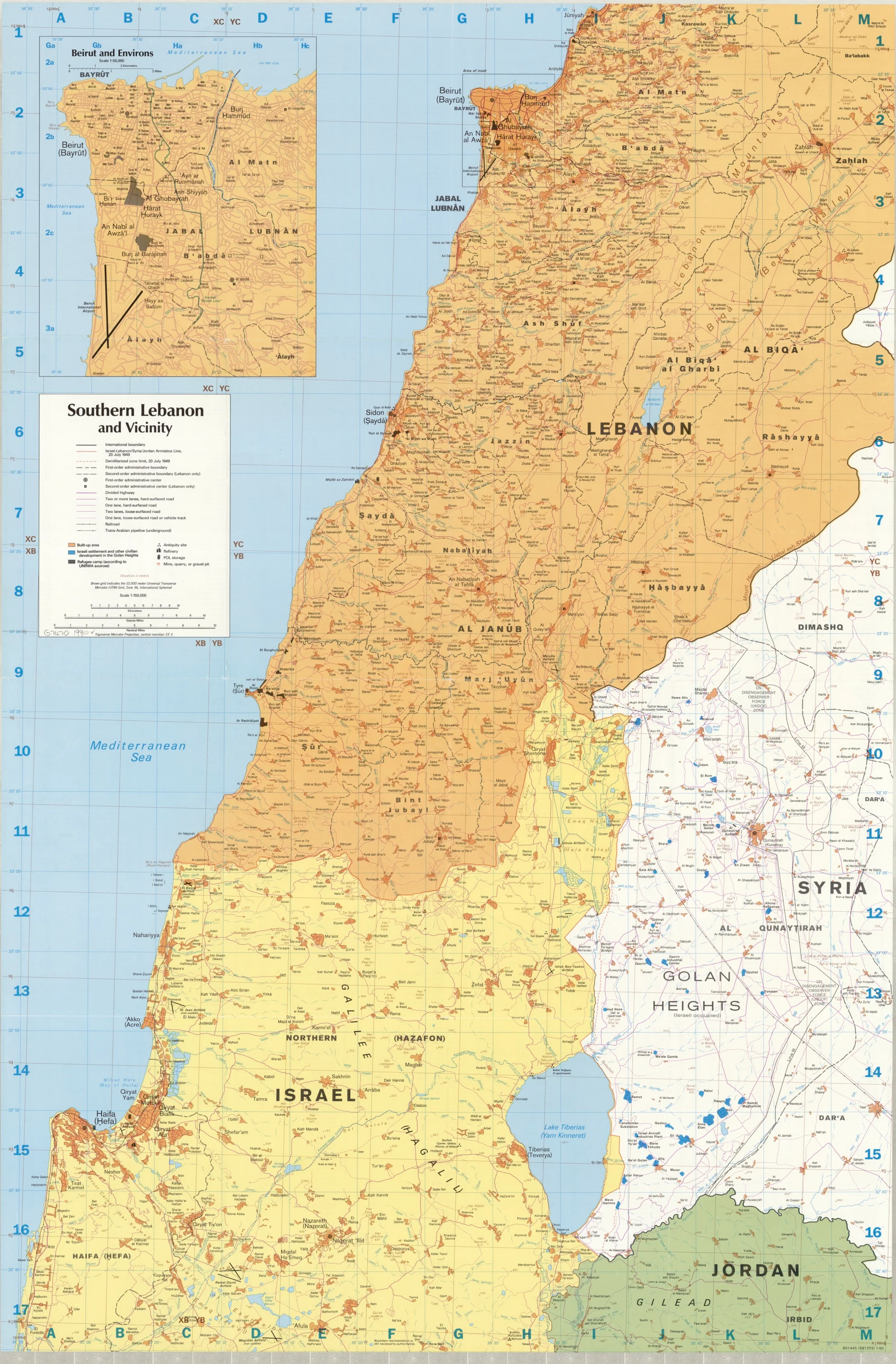
This 1990 CIA map of Southern Lebanon presents a meticulously detailed view of one of the most strategically important regions in the Middle East. Depicting political boundaries, settlements, infrastructure, and topography, it serves as both a valuable historical document and an authoritative cartographic resource.
Whether for historical study, educational reference, or distinguished display, this map captures the complexities of Southern Lebanon at a pivotal moment in the region’s history.
📜 Map Content & Features
-
Urban & Rural Areas – Cities, towns, villages, and built-up zones.
-
Infrastructure – Major and minor roads, railways, and border checkpoints.
-
Political Boundaries – International borders and internal demarcation lines.
-
Strategic & Military Detail – Key installations, restricted areas, and observation points.
-
Natural Features – Rivers, coastline, terrain relief shading, and spot heights.
-
Cultural & Historic Sites – Notable locations, heritage sites, and points of interest.
📐 Specifications
| Feature | Detail |
|---|---|
| Publication Year | 1990 |
| Publisher | Central Intelligence Agency (CIA) |
| Dimensions | 690 mm (W) x 1050 mm (H) |
| Relief | Shading & spot heights |
| Origin | Printed & finished in Australia |
✨ Available Finishes
| Format | Description |
|---|---|
| 🖨️ Paper (160 gsm) | Heavyweight matte-coated paper — ideal for framing under glass. |
| 🧼 Laminated (Encapsulated) | Fully sealed between two sheets of 80-micron gloss laminate. Wipe-clean, tear-resistant, and durable. |
| 🪵 Laminated with Wooden Hang Rails | Laminated map mounted with natural lacquered timber rails (top & bottom) and a sturdy hanging cord — ready to display. |
| 🖼️ Canvas (395 gsm) | HP Professional Matte Canvas printed with archival pigment-based inks — richly textured, fade-resistant, and gallery-quality. |
| 🪵 Canvas with Wooden Hang Rails | Canvas mounted with lacquered timber rails and a hanging cord for a timeless, display-ready finish. |
🔨 Please allow up to 10 working days for delivery of hang-railed maps, as each is professionally mounted by our framer.
💡 Why This Map Stands Out
✔️ Rare CIA archival reproduction
✔️ Comprehensive political, military, and topographic information
✔️ Museum-grade printing with outstanding clarity
✔️ Multiple display options — from archival storage to ready-to-hang presentation
✔️ Perfect for historians, educators, and collectors
🎯 Perfect For
-
Historians & Researchers – Primary source reference from the late Cold War era
-
Educational Use – Middle Eastern studies, political geography, and military history
-
Collectors – Archival-quality reproduction of a CIA regional map
-
Decor & Display – Offices, libraries, study rooms, and institutional settings
🚚 Delivery
-
Paper, Laminated, Canvas: Ships within 1–2 business days
-
Hang-Railed Versions: Ships within 10 working days (custom-mounted)
-
Securely rolled and packaged in a heavy-duty postal tube for safe arrival
The CIA 1990 Southern Lebanon Map offers a rare and authoritative visual record of a region at the heart of geopolitical change.
👉 Order today to own a professionally reproduced, museum-quality piece of cartographic history.
Original: $50.05
-65%$50.05
$17.52Product Information
Product Information
Shipping & Returns
Shipping & Returns
Description
Detailed Political, Military & Geographic Features | Premium Finishes
This 1990 CIA map of Southern Lebanon presents a meticulously detailed view of one of the most strategically important regions in the Middle East. Depicting political boundaries, settlements, infrastructure, and topography, it serves as both a valuable historical document and an authoritative cartographic resource.
Whether for historical study, educational reference, or distinguished display, this map captures the complexities of Southern Lebanon at a pivotal moment in the region’s history.
📜 Map Content & Features
-
Urban & Rural Areas – Cities, towns, villages, and built-up zones.
-
Infrastructure – Major and minor roads, railways, and border checkpoints.
-
Political Boundaries – International borders and internal demarcation lines.
-
Strategic & Military Detail – Key installations, restricted areas, and observation points.
-
Natural Features – Rivers, coastline, terrain relief shading, and spot heights.
-
Cultural & Historic Sites – Notable locations, heritage sites, and points of interest.
📐 Specifications
| Feature | Detail |
|---|---|
| Publication Year | 1990 |
| Publisher | Central Intelligence Agency (CIA) |
| Dimensions | 690 mm (W) x 1050 mm (H) |
| Relief | Shading & spot heights |
| Origin | Printed & finished in Australia |
✨ Available Finishes
| Format | Description |
|---|---|
| 🖨️ Paper (160 gsm) | Heavyweight matte-coated paper — ideal for framing under glass. |
| 🧼 Laminated (Encapsulated) | Fully sealed between two sheets of 80-micron gloss laminate. Wipe-clean, tear-resistant, and durable. |
| 🪵 Laminated with Wooden Hang Rails | Laminated map mounted with natural lacquered timber rails (top & bottom) and a sturdy hanging cord — ready to display. |
| 🖼️ Canvas (395 gsm) | HP Professional Matte Canvas printed with archival pigment-based inks — richly textured, fade-resistant, and gallery-quality. |
| 🪵 Canvas with Wooden Hang Rails | Canvas mounted with lacquered timber rails and a hanging cord for a timeless, display-ready finish. |
🔨 Please allow up to 10 working days for delivery of hang-railed maps, as each is professionally mounted by our framer.
💡 Why This Map Stands Out
✔️ Rare CIA archival reproduction
✔️ Comprehensive political, military, and topographic information
✔️ Museum-grade printing with outstanding clarity
✔️ Multiple display options — from archival storage to ready-to-hang presentation
✔️ Perfect for historians, educators, and collectors
🎯 Perfect For
-
Historians & Researchers – Primary source reference from the late Cold War era
-
Educational Use – Middle Eastern studies, political geography, and military history
-
Collectors – Archival-quality reproduction of a CIA regional map
-
Decor & Display – Offices, libraries, study rooms, and institutional settings
🚚 Delivery
-
Paper, Laminated, Canvas: Ships within 1–2 business days
-
Hang-Railed Versions: Ships within 10 working days (custom-mounted)
-
Securely rolled and packaged in a heavy-duty postal tube for safe arrival
The CIA 1990 Southern Lebanon Map offers a rare and authoritative visual record of a region at the heart of geopolitical change.
👉 Order today to own a professionally reproduced, museum-quality piece of cartographic history.


