Stanford's Folio Asia Map by J. Arrowsmith published 1884
Borders, Relief & Rivers — Stanford’s Asia Wall Map (1884)
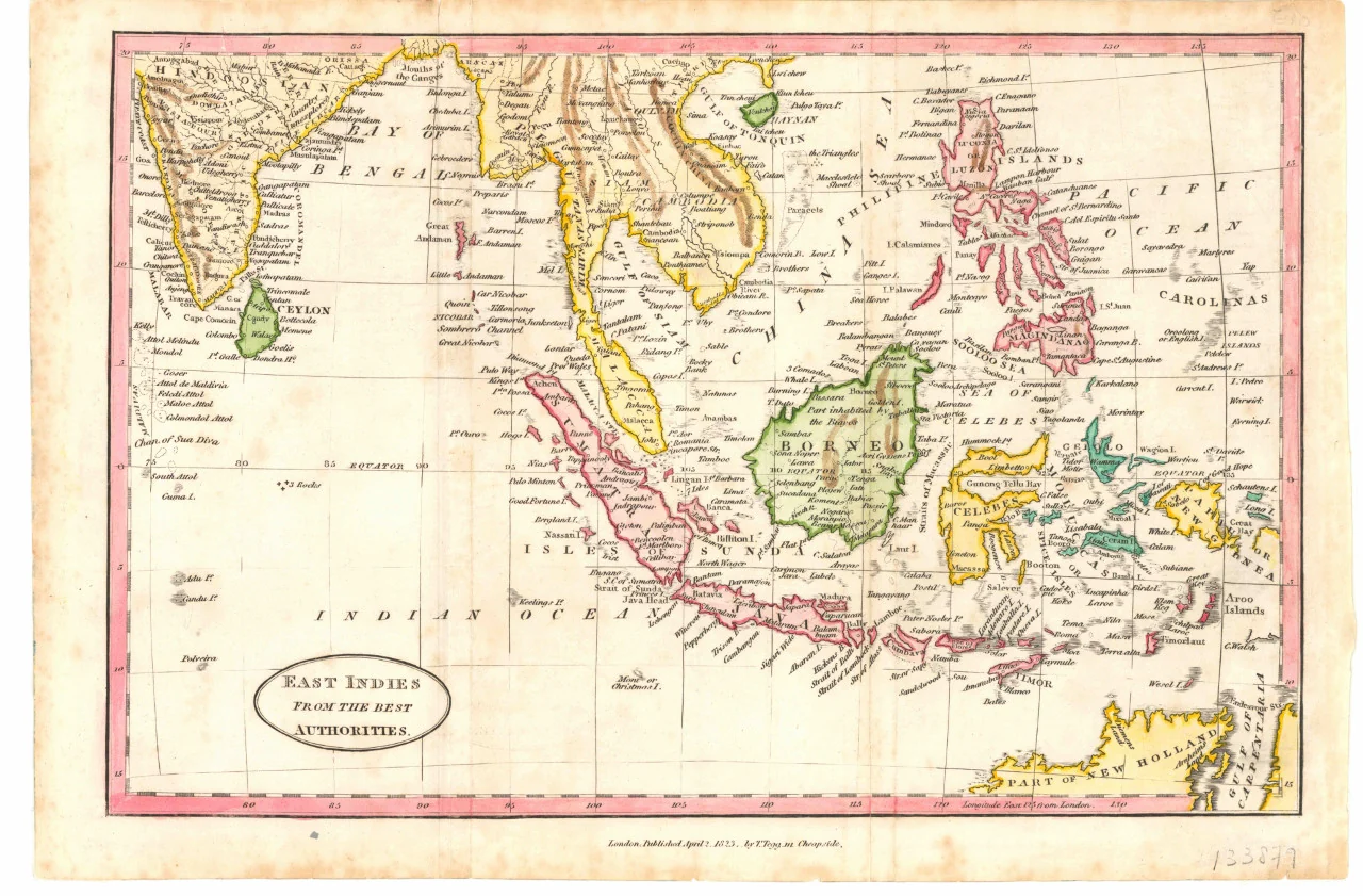
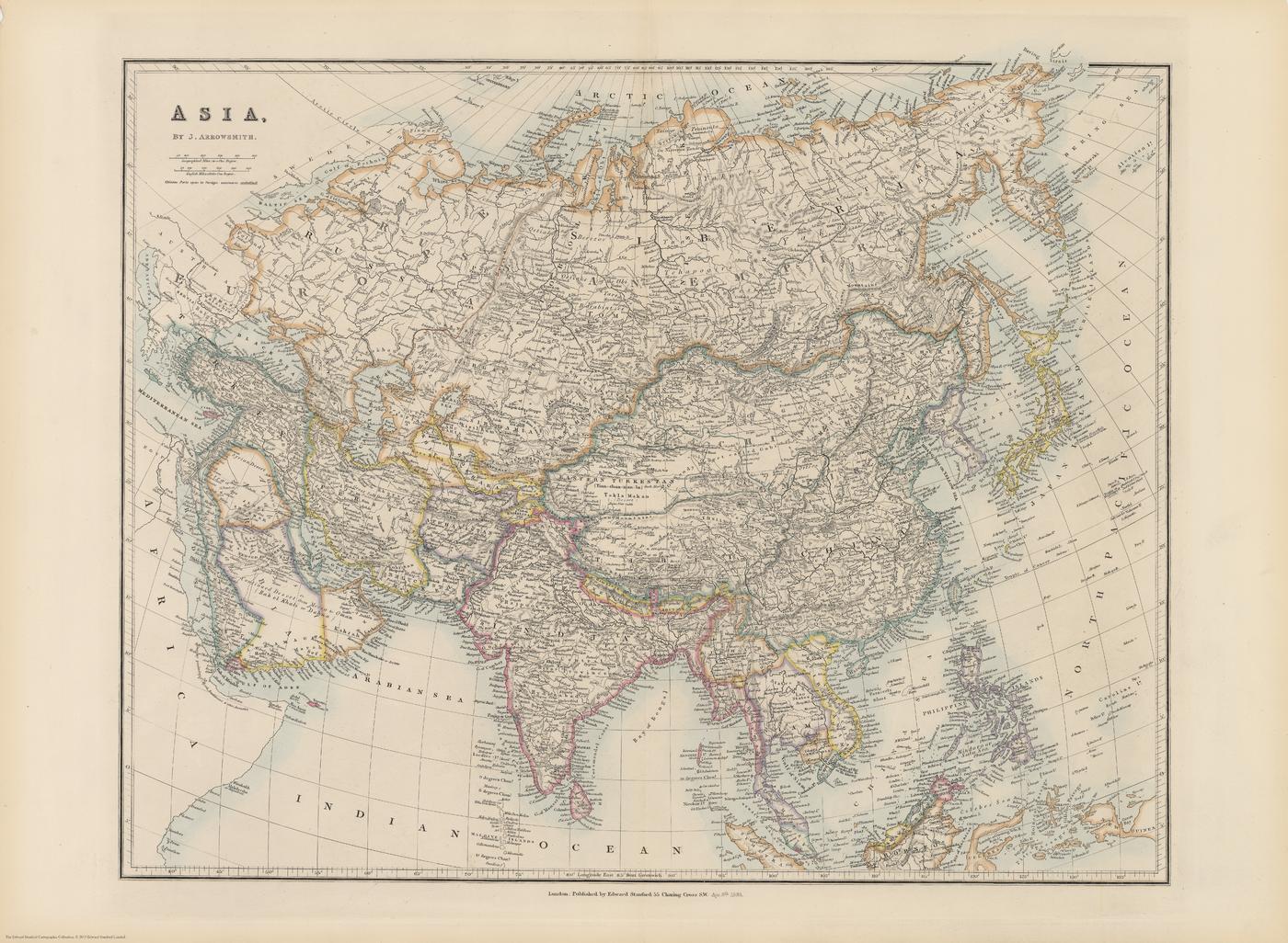
A snapshot of a continent in the late nineteenth century, rendered with clarity and restraint. This Asia sheet—made by John Arrowsmith and published by Edward Stanford in 1884—sets country boundaries in bright tints against a pale field with subtle hachures for mountain ranges. Major rivers and numerous tributaries—from the Ob, Yenisei, and Lena in the north to the Ganges and Irrawaddy in the south and the Yangtze in the east—are named with care. A 5° graticule aids orientation. Coverage extends north to the Arctic and south to the Equator (the far southern Indonesian islands fall beyond the sheet). It’s the fabric of nineteenth-century Asia—legible, comparative, and unmistakably of its era—made to study, admire, and display.
More Than a Map – A Testament to History
This isn’t just wall art—it’s a reference frame for Asia as empires shifted. Read Mongolia within China, Pan-regional frontiers in Central Asia and the Middle East that differ from today, and treaty ports in China underlined after the Second Opium War (with “Hong-kong I. & Victoria” annotated Cy for colony). Ideal for educators, historians, designers, and collectors, this sheet stands alone beautifully and pairs powerfully with modern political maps for then-and-now comparison.
Hang it in studios, libraries, classrooms, museums, offices, or at home to invite reflection, study, and conversation.
Premium Materials & Finishes
We treat history with the respect it deserves. That’s why we offer multiple formats, each produced using high-quality materials and modern archival printing.
🌟 Archival Paper Print
Printed on heavyweight 160gsm archival-grade paper.
Smooth matte finish reduces glare and preserves fine linework and small labels.
Ideal for framing under glass—clean, timeless, and built to last.
💎 Laminated Edition
Encapsulated in two sheets of 80-micron gloss laminate using true thermal bonding—not just surface lamination.
Moisture-resistant, wipe-clean surface—perfect for classrooms and high-traffic reference spaces.
Optional Natural Timber Hang Rails: lacquered rails with a fitted hanging cord provide a polished, ready-to-hang presentation—no frame required. (Please allow up to 10 working days for delivery with hang rails.)
🏆 Museum-Quality Canvas
Printed on heavyweight 395gsm HP Professional Matte Canvas for rich texture and exceptional strength.
Pigment-based, fade-resistant inks deliver deep tone and crisp typography that endure for generations.
Optional Natural Timber Hang Rails: lacquered to enhance the wood grain and protect against wear; top cord for effortless hanging—elegant in any setting. (Please allow up to 10 working days for delivery with hang rails.)
Specifications
| Feature | Details |
|---|---|
| Title | Stanford’s Asia Wall Map |
| Series | Stanford’s Folio series — reproduction from the Edward Stanford Cartographic Collection |
| Original Publication | 1884 (cartography by John Arrowsmith; published by Edward Stanford) |
| Scale | Not specified |
| Cartographic Content | Country boundaries (tinted); hachured relief; major rivers & named tributaries; cities & ports (treaty ports underlined); 5° graticule |
| Coverage | Arctic to Equator (southernmost Indonesia not included) |
| Map Size | 1000 mm (W) × 740 mm (H) |
| Available Formats | Paper, Laminated, Canvas |
| Paper Weight | 160gsm archival-quality |
| Laminate | 2 × 80-micron gloss laminate sheets (encapsulated) |
| Canvas Weight | 395gsm HP Professional Matte Canvas |
| Inks | Pigment-based, fade-resistant |
| Optional Hang Rails | Available on Laminated & Canvas (lead time up to 10 working days) |
| Origin | Made in Australia |
Why Choose This Map
✔ Era-True Snapshot: Asia’s political and commercial geography as presented in 1884.
✔ Clarity at Scale: Bright boundary tints, fine hachures, and a 5° grid make complex regions instantly readable.
✔ Research-Friendly: Dense river naming and treaty-port annotations enrich historical study.
✔ Decorative & Scholarly: Strong wall presence with genuine reference value.
✔ Archival Craft: Premium substrates and inks preserve contrast, labels, and linework for decades.
Our Commitment
We believe that preserving history is as important as telling it. Every map is printed locally in Australia using state-of-the-art technology, carefully checked by hand, and packed with care. From the moment it leaves our workshop to the day it hangs on your wall, we ensure quality you can trust and a legacy you’ll be proud to share.
Bring nineteenth-century Asia into focus. Order the Stanford’s Asia Wall Map (1884) today—a faithful, beautifully produced sheet that turns a room into a conversation.
Product Information
Product Information
Shipping & Returns
Shipping & Returns
Description
Borders, Relief & Rivers — Stanford’s Asia Wall Map (1884)
A snapshot of a continent in the late nineteenth century, rendered with clarity and restraint. This Asia sheet—made by John Arrowsmith and published by Edward Stanford in 1884—sets country boundaries in bright tints against a pale field with subtle hachures for mountain ranges. Major rivers and numerous tributaries—from the Ob, Yenisei, and Lena in the north to the Ganges and Irrawaddy in the south and the Yangtze in the east—are named with care. A 5° graticule aids orientation. Coverage extends north to the Arctic and south to the Equator (the far southern Indonesian islands fall beyond the sheet). It’s the fabric of nineteenth-century Asia—legible, comparative, and unmistakably of its era—made to study, admire, and display.
More Than a Map – A Testament to History
This isn’t just wall art—it’s a reference frame for Asia as empires shifted. Read Mongolia within China, Pan-regional frontiers in Central Asia and the Middle East that differ from today, and treaty ports in China underlined after the Second Opium War (with “Hong-kong I. & Victoria” annotated Cy for colony). Ideal for educators, historians, designers, and collectors, this sheet stands alone beautifully and pairs powerfully with modern political maps for then-and-now comparison.
Hang it in studios, libraries, classrooms, museums, offices, or at home to invite reflection, study, and conversation.
Premium Materials & Finishes
We treat history with the respect it deserves. That’s why we offer multiple formats, each produced using high-quality materials and modern archival printing.
🌟 Archival Paper Print
Printed on heavyweight 160gsm archival-grade paper.
Smooth matte finish reduces glare and preserves fine linework and small labels.
Ideal for framing under glass—clean, timeless, and built to last.
💎 Laminated Edition
Encapsulated in two sheets of 80-micron gloss laminate using true thermal bonding—not just surface lamination.
Moisture-resistant, wipe-clean surface—perfect for classrooms and high-traffic reference spaces.
Optional Natural Timber Hang Rails: lacquered rails with a fitted hanging cord provide a polished, ready-to-hang presentation—no frame required. (Please allow up to 10 working days for delivery with hang rails.)
🏆 Museum-Quality Canvas
Printed on heavyweight 395gsm HP Professional Matte Canvas for rich texture and exceptional strength.
Pigment-based, fade-resistant inks deliver deep tone and crisp typography that endure for generations.
Optional Natural Timber Hang Rails: lacquered to enhance the wood grain and protect against wear; top cord for effortless hanging—elegant in any setting. (Please allow up to 10 working days for delivery with hang rails.)
Specifications
| Feature | Details |
|---|---|
| Title | Stanford’s Asia Wall Map |
| Series | Stanford’s Folio series — reproduction from the Edward Stanford Cartographic Collection |
| Original Publication | 1884 (cartography by John Arrowsmith; published by Edward Stanford) |
| Scale | Not specified |
| Cartographic Content | Country boundaries (tinted); hachured relief; major rivers & named tributaries; cities & ports (treaty ports underlined); 5° graticule |
| Coverage | Arctic to Equator (southernmost Indonesia not included) |
| Map Size | 1000 mm (W) × 740 mm (H) |
| Available Formats | Paper, Laminated, Canvas |
| Paper Weight | 160gsm archival-quality |
| Laminate | 2 × 80-micron gloss laminate sheets (encapsulated) |
| Canvas Weight | 395gsm HP Professional Matte Canvas |
| Inks | Pigment-based, fade-resistant |
| Optional Hang Rails | Available on Laminated & Canvas (lead time up to 10 working days) |
| Origin | Made in Australia |
Why Choose This Map
✔ Era-True Snapshot: Asia’s political and commercial geography as presented in 1884.
✔ Clarity at Scale: Bright boundary tints, fine hachures, and a 5° grid make complex regions instantly readable.
✔ Research-Friendly: Dense river naming and treaty-port annotations enrich historical study.
✔ Decorative & Scholarly: Strong wall presence with genuine reference value.
✔ Archival Craft: Premium substrates and inks preserve contrast, labels, and linework for decades.
Our Commitment
We believe that preserving history is as important as telling it. Every map is printed locally in Australia using state-of-the-art technology, carefully checked by hand, and packed with care. From the moment it leaves our workshop to the day it hangs on your wall, we ensure quality you can trust and a legacy you’ll be proud to share.
Bring nineteenth-century Asia into focus. Order the Stanford’s Asia Wall Map (1884) today—a faithful, beautifully produced sheet that turns a room into a conversation.