Stanford's Map of Japan (1879)
Historic Meiji-Era Cartography | Museum-Scale Wall Map | Premium Finishes
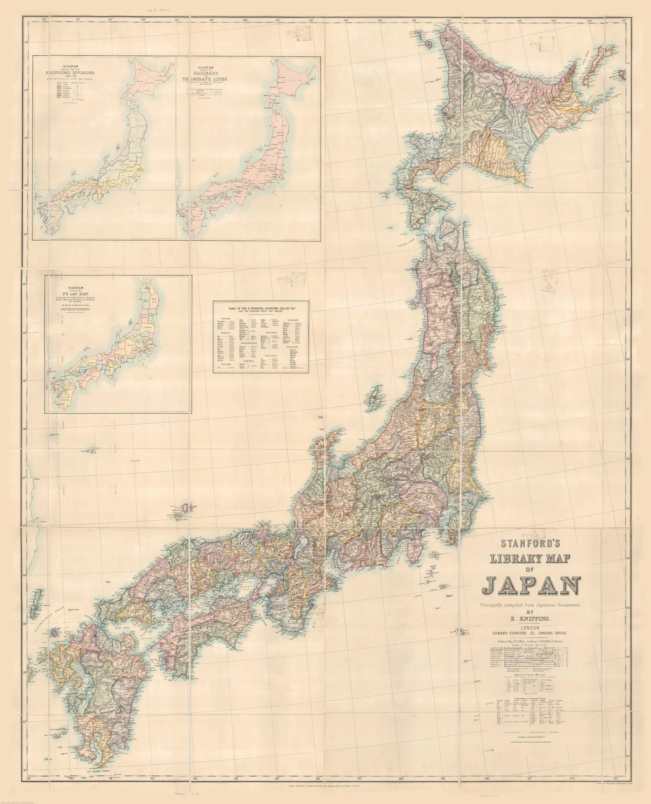
A commanding and deeply evocative portrait of Japan at a pivotal moment in its history, this 1879 map from Edward Stanford Ltd captures the nation during the early years of the Meiji Restoration—a time when centuries-old feudal structures were giving way to rapid modernisation.
Produced in London at a time when Western interest in Japan was surging, this map reflects both scholarly curiosity and imperial-era precision. It reveals a country still organised into traditional provinces, yet on the cusp of becoming a modern state. The result is a piece that is not just geographic—but historical, cultural, and deeply atmospheric.
Today, it stands as a museum-quality reproduction—rich in detail, beautifully composed, and perfectly suited for collectors, historians, and interiors that value substance as much as style.
⚓ Why This Map Stands Out
A nation at a turning point
This map captures Japan just after it reopened to the world—when samurai-era provinces still shaped identity, even as modern governance emerged.
Authentic 19th-century craftsmanship
Created in 1879, it reflects the engraving precision, typography, and compositional discipline of Victorian-era cartography.
Western perspective on a newly opened Japan
Offers a fascinating lens into how Japan was understood and documented by European mapmakers of the time.
Exceptional visual balance
Fine linework, coastal detail, and elegantly spaced labelling create a composition that is both readable and refined.
A true statement piece
At nearly 1.5 metres tall, this is not a small reference—it’s a feature wall map with presence, authority, and narrative depth.
🗺️ What the Map Shows
- The full archipelago of Japan, including Honshu, Hokkaido, Kyushu, and Shikoku
- Historical provincial boundaries prior to full modern administrative reform
- Key cities, ports, and early transport routes of the late 19th century
- Coastal hydrography and maritime approaches—vital to trade and foreign access
- Mountain ranges and terrain features rendered in classic engraved style
- A geographic framework shaped by both Japanese sources and European cartographic interpretation
This is Japan as it stood at the threshold of transformation—recognisable, yet distinctly different from today.
📐 Size
1189 mm (W) × 1468 mm (H)
Portrait orientation — a tall, elegant format that draws the eye upward and gives the map a gallery-like vertical presence.
Ideal for:
- Studies and libraries
- Hallways and feature walls
- Offices and boardrooms seeking a refined historical focal point
✨ Premium Finishes
| Format | Description |
|---|---|
| 📜 Paper (160 gsm) | Heavyweight matte-coated paper—perfect for traditional framing under glass. Preserves the fine engraving detail and vintage tones. |
| 🧼 Laminated (Encapsulated) | Sealed in 2 × 80-micron gloss laminate. Durable, moisture-resistant, and wipe-clean—ideal for high-use or educational settings. |
| 🪵 Laminated + Timber Hang Rails | Laminated map fitted with lacquered natural timber rails and hanging cord—ready to hang with a clean, professional finish. |
| 🖼️ Canvas (395 gsm HP Professional Matte) | Printed using archival pigment-based inks on premium canvas. Soft texture reduces glare and enhances the antique aesthetic. |
| 🪵 Canvas + Timber Hang Rails | Canvas mounted with timber rails for a refined, frame-free presentation—gallery-ready and visually striking. |
🔨 Please allow up to 10 working days for professionally mounted hang-railed finishes.
📊 Specifications
| Feature | Detail |
|---|---|
| Title | Stanford’s Map of Japan |
| Date | 1879 |
| Publisher | Edward Stanford Ltd (London) |
| Dimensions | 1189 mm (W) × 1468 mm (H) |
| Orientation | Portrait |
| Map Type | Historical / Political |
| Historical Context | Early Meiji-era Japan |
| Materials | 160 gsm matte paper / 2 × 80-micron laminate / 395 gsm HP Professional Matte Canvas |
| Printing | Pigment-based, fade-resistant inks |
| Origin | Printed and finished in Australia |
🎯 Ideal For
- Collectors of antique and historical maps
- Enthusiasts of Japanese history and the Meiji period
- Academics and educators in history, geography, and Asian studies
- Interior designers creating heritage-inspired or library-style spaces
- Gift buyers seeking something intellectual, timeless, and distinctive
🏯 A Map with Historical Depth
The late 19th century was a defining era for Japan. Following centuries of relative isolation, the country rapidly modernised—adopting new technologies, restructuring governance, and redefining its place in the world.
This map captures that moment of dual identity:
- Traditional provinces still mapped and named
- Western surveying methods beginning to standardise geography
- Ports and coastlines gaining new strategic importance
It is, in essence, a portrait of a nation between worlds.
🤝 Our Commitment
- Printed in Australia using archival production methods
- Carefully colour-managed to retain the authentic tones of the original engraving
- Produced on premium materials for long-term display and durability
- Each map is hand-checked and professionally finished
- Packaged with care to arrive in pristine condition
🚚 Delivery
- Paper, Laminated, Canvas (rolled): Dispatch within 1–2 business days
- Hang-Railed Maps: Made to order—please allow up to 10 working days
- Packaging: Securely rolled in heavy-duty protective tubing
Bring the elegance, history, and quiet authority of 19th-century Japan into your space with a map that rewards close study and long appreciation.
👉 Order now and own a piece of cartographic history that continues to speak across time.
Original: $286.15
-65%$286.15
$100.15Product Information
Product Information
Shipping & Returns
Shipping & Returns
Description
Historic Meiji-Era Cartography | Museum-Scale Wall Map | Premium Finishes
A commanding and deeply evocative portrait of Japan at a pivotal moment in its history, this 1879 map from Edward Stanford Ltd captures the nation during the early years of the Meiji Restoration—a time when centuries-old feudal structures were giving way to rapid modernisation.
Produced in London at a time when Western interest in Japan was surging, this map reflects both scholarly curiosity and imperial-era precision. It reveals a country still organised into traditional provinces, yet on the cusp of becoming a modern state. The result is a piece that is not just geographic—but historical, cultural, and deeply atmospheric.
Today, it stands as a museum-quality reproduction—rich in detail, beautifully composed, and perfectly suited for collectors, historians, and interiors that value substance as much as style.
⚓ Why This Map Stands Out
A nation at a turning point
This map captures Japan just after it reopened to the world—when samurai-era provinces still shaped identity, even as modern governance emerged.
Authentic 19th-century craftsmanship
Created in 1879, it reflects the engraving precision, typography, and compositional discipline of Victorian-era cartography.
Western perspective on a newly opened Japan
Offers a fascinating lens into how Japan was understood and documented by European mapmakers of the time.
Exceptional visual balance
Fine linework, coastal detail, and elegantly spaced labelling create a composition that is both readable and refined.
A true statement piece
At nearly 1.5 metres tall, this is not a small reference—it’s a feature wall map with presence, authority, and narrative depth.
🗺️ What the Map Shows
- The full archipelago of Japan, including Honshu, Hokkaido, Kyushu, and Shikoku
- Historical provincial boundaries prior to full modern administrative reform
- Key cities, ports, and early transport routes of the late 19th century
- Coastal hydrography and maritime approaches—vital to trade and foreign access
- Mountain ranges and terrain features rendered in classic engraved style
- A geographic framework shaped by both Japanese sources and European cartographic interpretation
This is Japan as it stood at the threshold of transformation—recognisable, yet distinctly different from today.
📐 Size
1189 mm (W) × 1468 mm (H)
Portrait orientation — a tall, elegant format that draws the eye upward and gives the map a gallery-like vertical presence.
Ideal for:
- Studies and libraries
- Hallways and feature walls
- Offices and boardrooms seeking a refined historical focal point
✨ Premium Finishes
| Format | Description |
|---|---|
| 📜 Paper (160 gsm) | Heavyweight matte-coated paper—perfect for traditional framing under glass. Preserves the fine engraving detail and vintage tones. |
| 🧼 Laminated (Encapsulated) | Sealed in 2 × 80-micron gloss laminate. Durable, moisture-resistant, and wipe-clean—ideal for high-use or educational settings. |
| 🪵 Laminated + Timber Hang Rails | Laminated map fitted with lacquered natural timber rails and hanging cord—ready to hang with a clean, professional finish. |
| 🖼️ Canvas (395 gsm HP Professional Matte) | Printed using archival pigment-based inks on premium canvas. Soft texture reduces glare and enhances the antique aesthetic. |
| 🪵 Canvas + Timber Hang Rails | Canvas mounted with timber rails for a refined, frame-free presentation—gallery-ready and visually striking. |
🔨 Please allow up to 10 working days for professionally mounted hang-railed finishes.
📊 Specifications
| Feature | Detail |
|---|---|
| Title | Stanford’s Map of Japan |
| Date | 1879 |
| Publisher | Edward Stanford Ltd (London) |
| Dimensions | 1189 mm (W) × 1468 mm (H) |
| Orientation | Portrait |
| Map Type | Historical / Political |
| Historical Context | Early Meiji-era Japan |
| Materials | 160 gsm matte paper / 2 × 80-micron laminate / 395 gsm HP Professional Matte Canvas |
| Printing | Pigment-based, fade-resistant inks |
| Origin | Printed and finished in Australia |
🎯 Ideal For
- Collectors of antique and historical maps
- Enthusiasts of Japanese history and the Meiji period
- Academics and educators in history, geography, and Asian studies
- Interior designers creating heritage-inspired or library-style spaces
- Gift buyers seeking something intellectual, timeless, and distinctive
🏯 A Map with Historical Depth
The late 19th century was a defining era for Japan. Following centuries of relative isolation, the country rapidly modernised—adopting new technologies, restructuring governance, and redefining its place in the world.
This map captures that moment of dual identity:
- Traditional provinces still mapped and named
- Western surveying methods beginning to standardise geography
- Ports and coastlines gaining new strategic importance
It is, in essence, a portrait of a nation between worlds.
🤝 Our Commitment
- Printed in Australia using archival production methods
- Carefully colour-managed to retain the authentic tones of the original engraving
- Produced on premium materials for long-term display and durability
- Each map is hand-checked and professionally finished
- Packaged with care to arrive in pristine condition
🚚 Delivery
- Paper, Laminated, Canvas (rolled): Dispatch within 1–2 business days
- Hang-Railed Maps: Made to order—please allow up to 10 working days
- Packaging: Securely rolled in heavy-duty protective tubing
Bring the elegance, history, and quiet authority of 19th-century Japan into your space with a map that rewards close study and long appreciation.
👉 Order now and own a piece of cartographic history that continues to speak across time.