Stanford's Railway Map of the United States published 1876
Rails, States & Cities — Stanford’s Railway Map of the United States (1876)
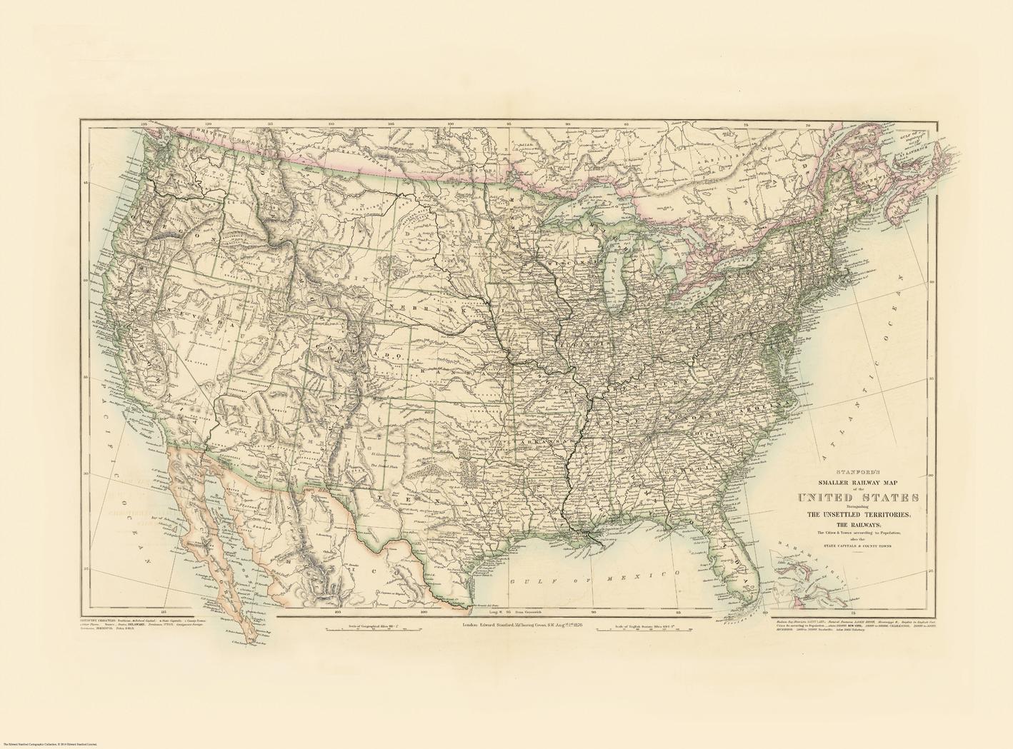
A snapshot of a nation in the age of steam, rendered with clarity and restraint. This United States sheet—published in 1876 as Stanford’s Folio Smaller Railway Map and reproduced from the Edward Stanford Cartographic Collection—brings the post–Civil War network into sharp focus. Main and subsidiary railway lines, junctions, state boundaries, towns and cities, and hydrography (rivers, lakes, coastline) are set out in clean, legible cartography that rewards both room-distance viewing and close study. It’s the fabric of rail-era America—connected, navigable, and unmistakably of its time—made to study, admire, and display.
More Than a Map – A Testament to History
This isn’t just wall art—it’s a reference frame for how the United States moved goods, people, and ideas in the Centennial year. Every route, crossing, and boundary captures commerce, migration, and regional growth at a pivotal moment. Ideal for educators, genealogists, historians, designers, and collectors, this sheet stands alone beautifully and pairs powerfully with modern transport maps for then-and-now comparisons.
Hang it in studios, libraries, classrooms, museums, offices, or at home to invite reflection, study, and conversation.
Premium Materials & Finishes
We treat history with the respect it deserves. That’s why we offer multiple formats, each produced using high-quality materials and modern archival printing.
🌟 Archival Paper Print
Printed on heavyweight 160gsm archival-grade paper.
Smooth matte finish reduces glare and preserves fine linework and small labels.
Ideal for framing under glass—clean, timeless, and built to last.
💎 Laminated Edition
Encapsulated in two sheets of 80-micron gloss laminate using true thermal bonding—not just surface lamination.
Moisture-resistant, wipe-clean surface—perfect for classrooms and high-traffic reference spaces.
Great for research: use whiteboard markers or apply map dots to mark locations without permanently altering the map.
ptional Natural Timber Hang Rails: lacquered rails with a fitted hanging cord provide a polished, ready-to-hang presentation—no frame required. (Please allow up to 10 working days for delivery with hang rails.)
🏆 Museum-Quality Canvas
Printed on heavyweight 395gsm HP Professional Matte Canvas for rich texture and exceptional strength.
Pigment-based, fade-resistant inks deliver deep tone and crisp typography that endure for generations.
Optional Natural Timber Hang Rails: lacquered to enhance the wood grain and protect against wear; top cord for effortless hanging—elegant in any setting. (Please allow up to 10 working days for delivery with hang rails.)
Specifications
| Feature | Details |
|---|---|
| Title | Stanford’s Railway Map of the United States |
| Series | Stanford’s Folio Smaller series (reproduction from the Edward Stanford Cartographic Collection) |
| Original Publication | 1876 |
| Scale | Not specified |
| Cartographic Content | Railways (main & subsidiary); stations/junctions; state boundaries; towns/cities; rivers; lakes; coastline |
| Map Size | 1000 mm (W) × 740 mm (H) |
| Available Formats | Paper, Laminated, Canvas |
| Paper Weight | 160gsm archival-quality |
| Laminate | 2 × 80-micron gloss laminate sheets (encapsulated) |
| Canvas Weight | 395gsm HP Professional Matte Canvas |
| Inks | Pigment-based, fade-resistant |
| Optional Hang Rails | Available on Laminated & Canvas (lead time up to 10 working days) |
| Origin | Made in Australia |
Why Choose This Map
✔ Era-True Snapshot: America’s railway geography as presented in 1876.
✔ Clarity at Scale: Elegant symbology reads beautifully across a room and up close.
✔ Genealogy & Research Friendly: Laminated option supports dry-erase notes and map dots.
✔ Decorative & Scholarly: Strong wall presence with genuine reference value.
✔ Archival Craft: Premium substrates and inks preserve contrast, labels, and linework for decades.
Our Commitment
We believe that preserving history is as important as telling it. Every map is printed locally in Australia using state-of-the-art technology, carefully checked by hand, and packed with care. From the moment it leaves our workshop to the day it hangs on your wall, we ensure quality you can trust and a legacy you’ll be proud to share.
Bring the age of steam into focus. Order the Stanford’s Railway Map of the United States (1876) today—a faithful, beautifully produced sheet that turns a room into a conversation.
Original: $57.20
-65%$57.20
$20.02Product Information
Product Information
Shipping & Returns
Shipping & Returns
Description
Rails, States & Cities — Stanford’s Railway Map of the United States (1876)
A snapshot of a nation in the age of steam, rendered with clarity and restraint. This United States sheet—published in 1876 as Stanford’s Folio Smaller Railway Map and reproduced from the Edward Stanford Cartographic Collection—brings the post–Civil War network into sharp focus. Main and subsidiary railway lines, junctions, state boundaries, towns and cities, and hydrography (rivers, lakes, coastline) are set out in clean, legible cartography that rewards both room-distance viewing and close study. It’s the fabric of rail-era America—connected, navigable, and unmistakably of its time—made to study, admire, and display.
More Than a Map – A Testament to History
This isn’t just wall art—it’s a reference frame for how the United States moved goods, people, and ideas in the Centennial year. Every route, crossing, and boundary captures commerce, migration, and regional growth at a pivotal moment. Ideal for educators, genealogists, historians, designers, and collectors, this sheet stands alone beautifully and pairs powerfully with modern transport maps for then-and-now comparisons.
Hang it in studios, libraries, classrooms, museums, offices, or at home to invite reflection, study, and conversation.
Premium Materials & Finishes
We treat history with the respect it deserves. That’s why we offer multiple formats, each produced using high-quality materials and modern archival printing.
🌟 Archival Paper Print
Printed on heavyweight 160gsm archival-grade paper.
Smooth matte finish reduces glare and preserves fine linework and small labels.
Ideal for framing under glass—clean, timeless, and built to last.
💎 Laminated Edition
Encapsulated in two sheets of 80-micron gloss laminate using true thermal bonding—not just surface lamination.
Moisture-resistant, wipe-clean surface—perfect for classrooms and high-traffic reference spaces.
Great for research: use whiteboard markers or apply map dots to mark locations without permanently altering the map.
ptional Natural Timber Hang Rails: lacquered rails with a fitted hanging cord provide a polished, ready-to-hang presentation—no frame required. (Please allow up to 10 working days for delivery with hang rails.)
🏆 Museum-Quality Canvas
Printed on heavyweight 395gsm HP Professional Matte Canvas for rich texture and exceptional strength.
Pigment-based, fade-resistant inks deliver deep tone and crisp typography that endure for generations.
Optional Natural Timber Hang Rails: lacquered to enhance the wood grain and protect against wear; top cord for effortless hanging—elegant in any setting. (Please allow up to 10 working days for delivery with hang rails.)
Specifications
| Feature | Details |
|---|---|
| Title | Stanford’s Railway Map of the United States |
| Series | Stanford’s Folio Smaller series (reproduction from the Edward Stanford Cartographic Collection) |
| Original Publication | 1876 |
| Scale | Not specified |
| Cartographic Content | Railways (main & subsidiary); stations/junctions; state boundaries; towns/cities; rivers; lakes; coastline |
| Map Size | 1000 mm (W) × 740 mm (H) |
| Available Formats | Paper, Laminated, Canvas |
| Paper Weight | 160gsm archival-quality |
| Laminate | 2 × 80-micron gloss laminate sheets (encapsulated) |
| Canvas Weight | 395gsm HP Professional Matte Canvas |
| Inks | Pigment-based, fade-resistant |
| Optional Hang Rails | Available on Laminated & Canvas (lead time up to 10 working days) |
| Origin | Made in Australia |
Why Choose This Map
✔ Era-True Snapshot: America’s railway geography as presented in 1876.
✔ Clarity at Scale: Elegant symbology reads beautifully across a room and up close.
✔ Genealogy & Research Friendly: Laminated option supports dry-erase notes and map dots.
✔ Decorative & Scholarly: Strong wall presence with genuine reference value.
✔ Archival Craft: Premium substrates and inks preserve contrast, labels, and linework for decades.
Our Commitment
We believe that preserving history is as important as telling it. Every map is printed locally in Australia using state-of-the-art technology, carefully checked by hand, and packed with care. From the moment it leaves our workshop to the day it hangs on your wall, we ensure quality you can trust and a legacy you’ll be proud to share.
Bring the age of steam into focus. Order the Stanford’s Railway Map of the United States (1876) today—a faithful, beautifully produced sheet that turns a room into a conversation.