Sydney UBD 262 Map 1020 x 1480mm Laminated Wall Map with Hang Rails
Size: 1020 mm (H) x 1480 mm (W) | Choose from 10 km or 75 km Radius Coverage
An exceptionally detailed, office-ready map of Sydney — perfect for planning, logistics, or display.
🌆 Two Powerful Views of Greater Sydney — You Choose
Produced by UBD Gregory’s, Australia’s most trusted name in urban cartography, this high-resolution laminated wall map offers a choice between two incredibly detailed perspectives of Sydney. Whether you need a close-up view of the city centre or a wide-ranging overview of Greater Sydney’s full extent, this map delivers unmatched clarity and utility.
📌 Important: This is a print-on-demand product, so only one side of the map can be displayed. Please select your preferred view from the dropdown menu.
Map Coverage Options
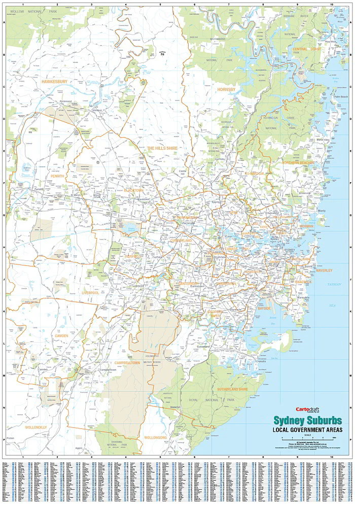
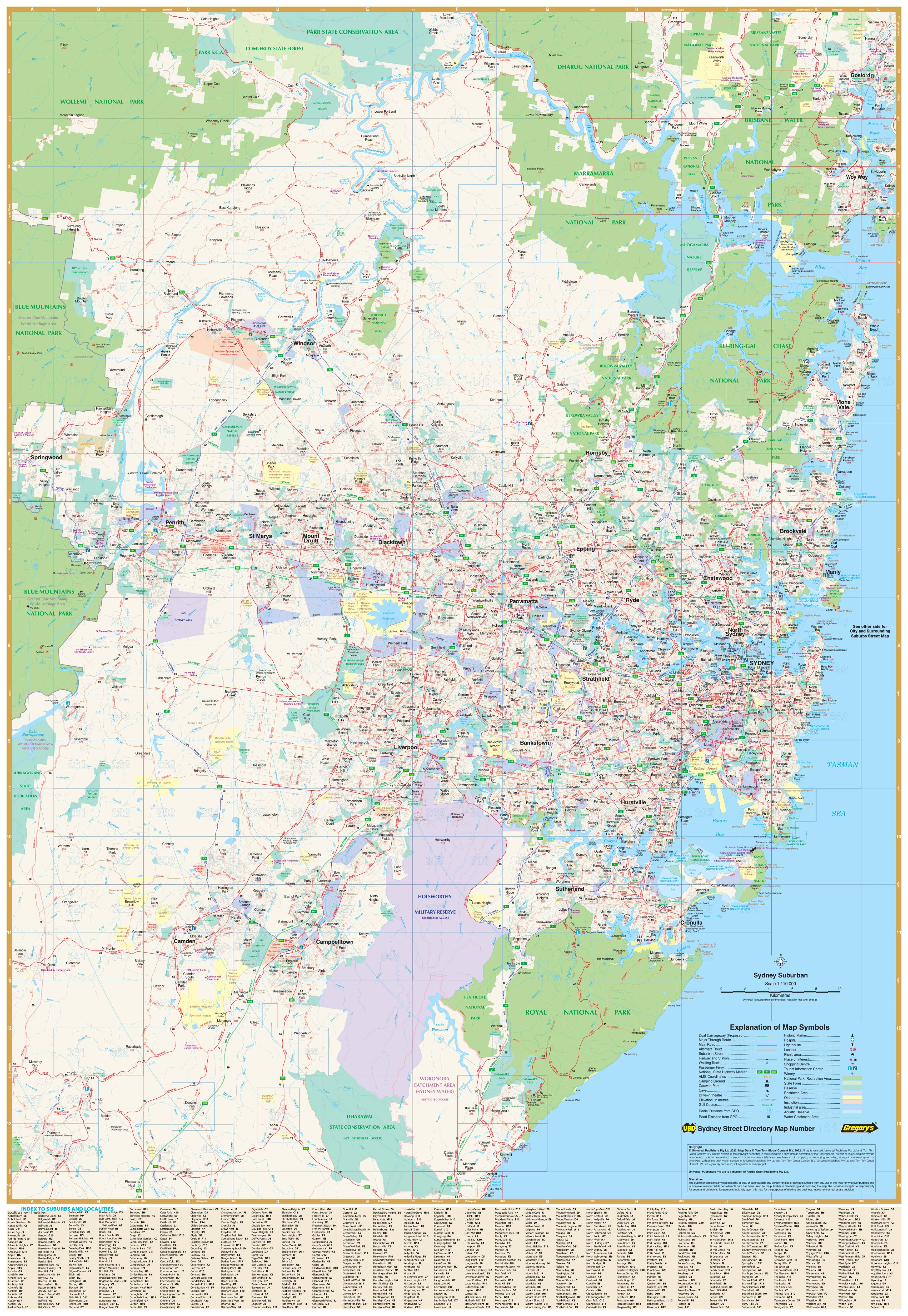
Option 1: 10 km Radius – Street Level Detail
-
Street-level mapping of inner Sydney
-
Covers from Gordon (NW) to North Curl Curl (NE), Monterey (SW) to Malabar (SE)
-
Ideal for local service areas, logistics, and transport planning
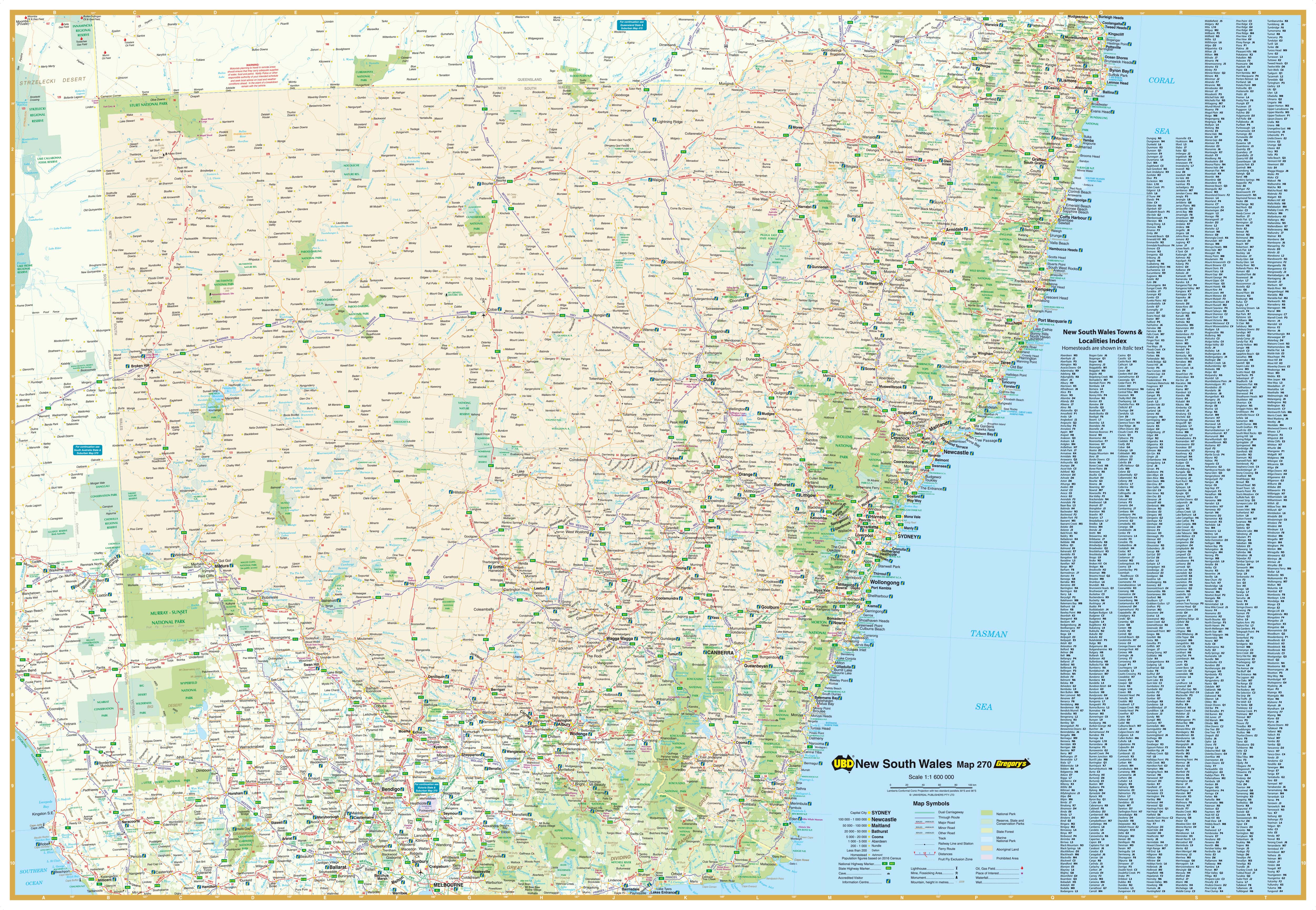
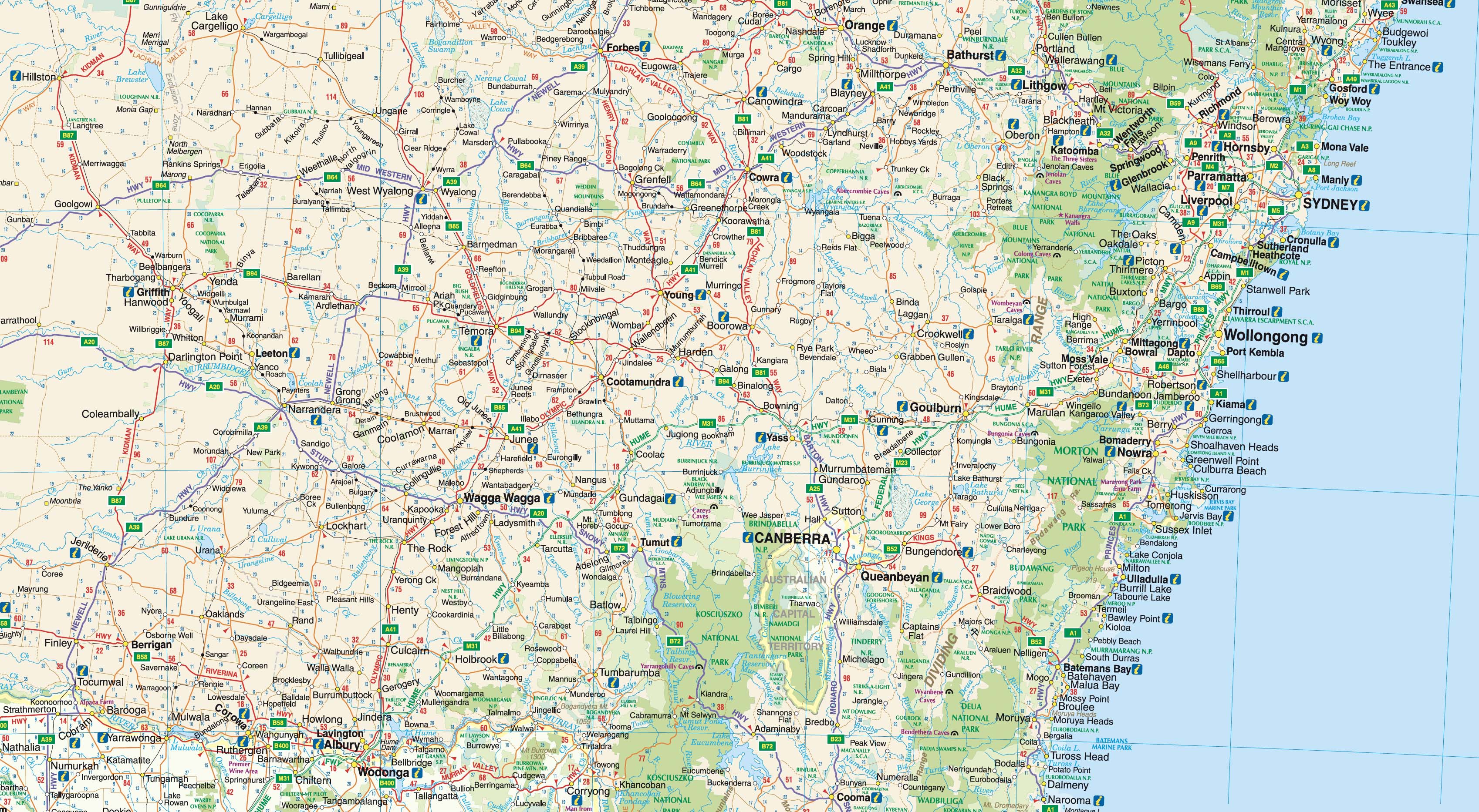
Option 2: 75 km Radius – Greater Sydney Overview
-
Broad coverage with arterial roads and major routes clearly marked
-
Extends from Gosford (N) to Clifton (S), and west to Springwood
-
Displays built-up areas, suburb boundaries, national parks, and industrial zones
Key Features
| Feature | Benefit |
|---|---|
| Suburb names and postcodes | Every suburb clearly labelled and indexed |
| Arterial routes & road networks | Ideal for logistics, delivery zones, and fleet management |
| Built-up areas, national parks & zones | Urban planning and demographic overview |
| Laminated with 80-micron gloss | Durable, waterproof, and wipe-clean surface |
| Compatible with map dots & markers | Write-on/wipe-off for planning and route marking |
| Timber hang rails included | Ready to hang — elegant natural finish with top cord for simple mounting |
📐 Product Specifications
| Specification | Description |
|---|---|
| Map Title | Sydney UBD 262 Wall Map |
| Publisher | UBD Gregory’s |
| Coverage | Choice of 10 km or 75 km radius from Sydney CBD |
| Format | Laminated map with hang rails (top & bottom) |
| Material | Encapsulated with 80-micron gloss laminate |
| Hang System | Natural timber rails with top cord |
| Size | 1020 mm (H) x 1480 mm (W) |
| Custom Printed | Yes — Print on Demand |
| Delivery Time | Please allow 10 working days for production and delivery |
🎯 Perfect For:
-
🏢 Corporate offices and logistics teams needing suburb-level clarity
-
🧭 Planners, couriers, and dispatch operators navigating Greater Sydney
-
🏠 Home offices or map-lovers wanting a visual of Sydney’s urban sprawl
-
🧑🏫 Educational use for teaching geography and urban infrastructure
Precision meets practicality in this professionally laminated Sydney wall map.
Select your preferred coverage — inner-city or regional — and elevate your wall with clarity and purpose.
Original: $357.02
-65%$357.02
$124.96Product Information
Product Information
Shipping & Returns
Shipping & Returns
Description
Size: 1020 mm (H) x 1480 mm (W) | Choose from 10 km or 75 km Radius Coverage
An exceptionally detailed, office-ready map of Sydney — perfect for planning, logistics, or display.
🌆 Two Powerful Views of Greater Sydney — You Choose
Produced by UBD Gregory’s, Australia’s most trusted name in urban cartography, this high-resolution laminated wall map offers a choice between two incredibly detailed perspectives of Sydney. Whether you need a close-up view of the city centre or a wide-ranging overview of Greater Sydney’s full extent, this map delivers unmatched clarity and utility.
📌 Important: This is a print-on-demand product, so only one side of the map can be displayed. Please select your preferred view from the dropdown menu.
Map Coverage Options
Option 1: 10 km Radius – Street Level Detail
-
Street-level mapping of inner Sydney
-
Covers from Gordon (NW) to North Curl Curl (NE), Monterey (SW) to Malabar (SE)
-
Ideal for local service areas, logistics, and transport planning
Option 2: 75 km Radius – Greater Sydney Overview
-
Broad coverage with arterial roads and major routes clearly marked
-
Extends from Gosford (N) to Clifton (S), and west to Springwood
-
Displays built-up areas, suburb boundaries, national parks, and industrial zones
Key Features
| Feature | Benefit |
|---|---|
| Suburb names and postcodes | Every suburb clearly labelled and indexed |
| Arterial routes & road networks | Ideal for logistics, delivery zones, and fleet management |
| Built-up areas, national parks & zones | Urban planning and demographic overview |
| Laminated with 80-micron gloss | Durable, waterproof, and wipe-clean surface |
| Compatible with map dots & markers | Write-on/wipe-off for planning and route marking |
| Timber hang rails included | Ready to hang — elegant natural finish with top cord for simple mounting |
📐 Product Specifications
| Specification | Description |
|---|---|
| Map Title | Sydney UBD 262 Wall Map |
| Publisher | UBD Gregory’s |
| Coverage | Choice of 10 km or 75 km radius from Sydney CBD |
| Format | Laminated map with hang rails (top & bottom) |
| Material | Encapsulated with 80-micron gloss laminate |
| Hang System | Natural timber rails with top cord |
| Size | 1020 mm (H) x 1480 mm (W) |
| Custom Printed | Yes — Print on Demand |
| Delivery Time | Please allow 10 working days for production and delivery |
🎯 Perfect For:
-
🏢 Corporate offices and logistics teams needing suburb-level clarity
-
🧭 Planners, couriers, and dispatch operators navigating Greater Sydney
-
🏠 Home offices or map-lovers wanting a visual of Sydney’s urban sprawl
-
🧑🏫 Educational use for teaching geography and urban infrastructure
Precision meets practicality in this professionally laminated Sydney wall map.
Select your preferred coverage — inner-city or regional — and elevate your wall with clarity and purpose.