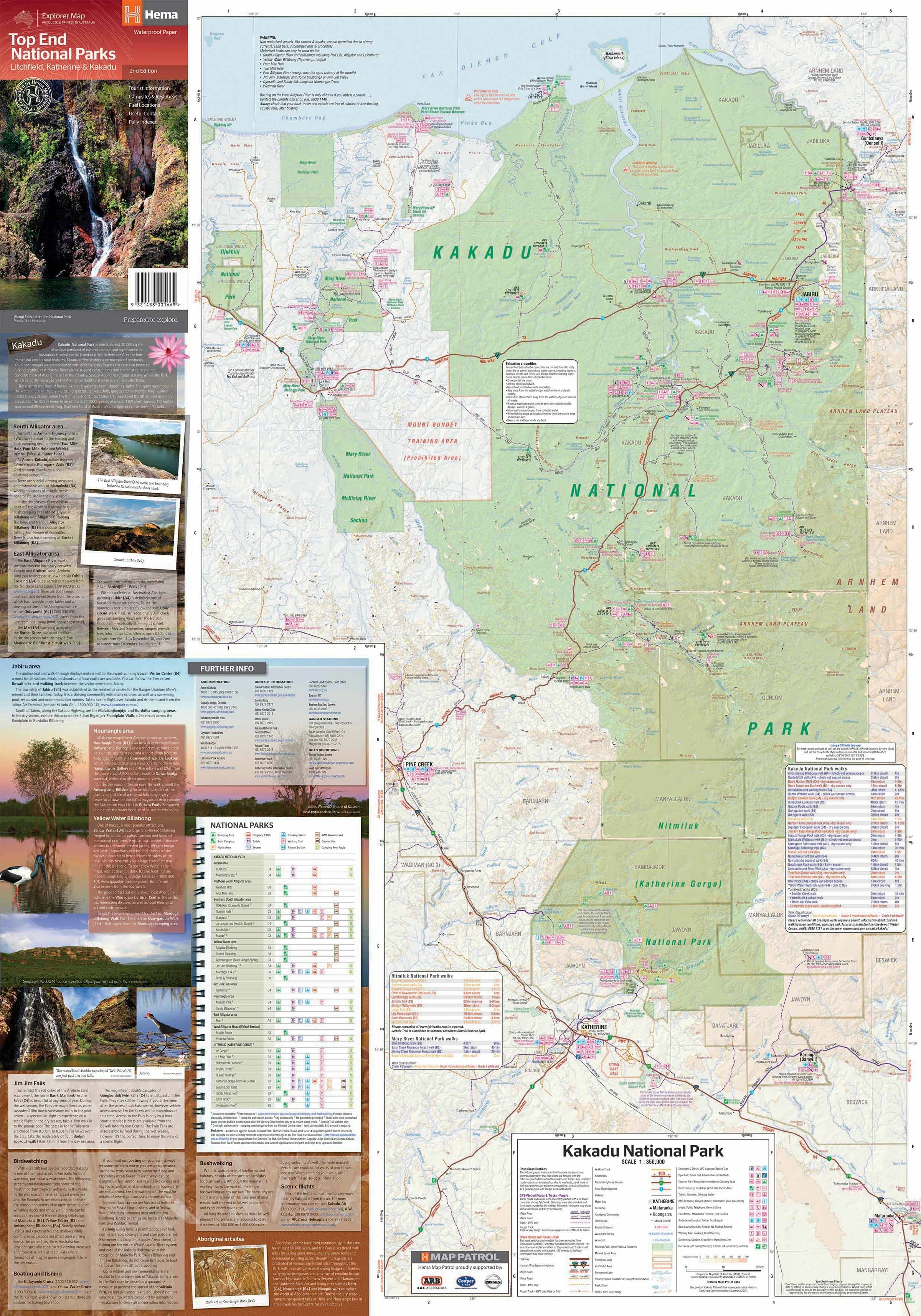
Top End National Parks Hema 700 x 1000mm Laminated Wall Map
🐊 Top End National Parks Wall Map – Laminated (Hema Maps)
Kakadu • Nitmiluk • Litchfield — The Heart of the Northern Territory in One Striking Map
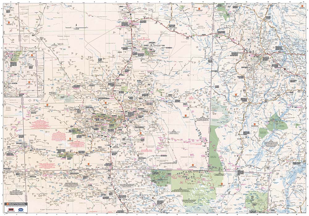
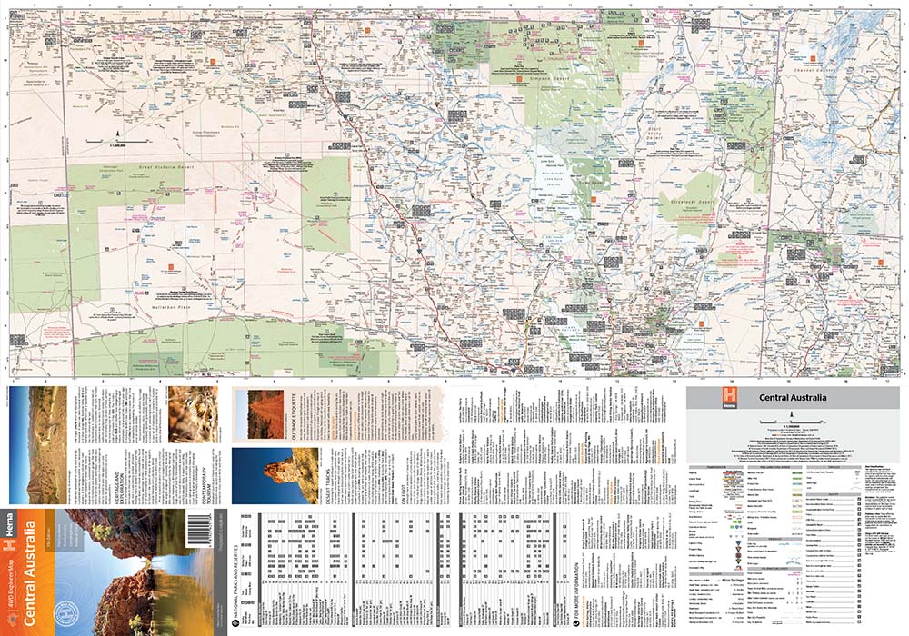
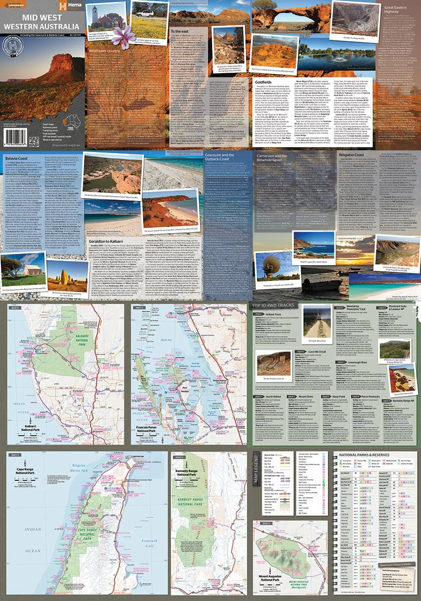
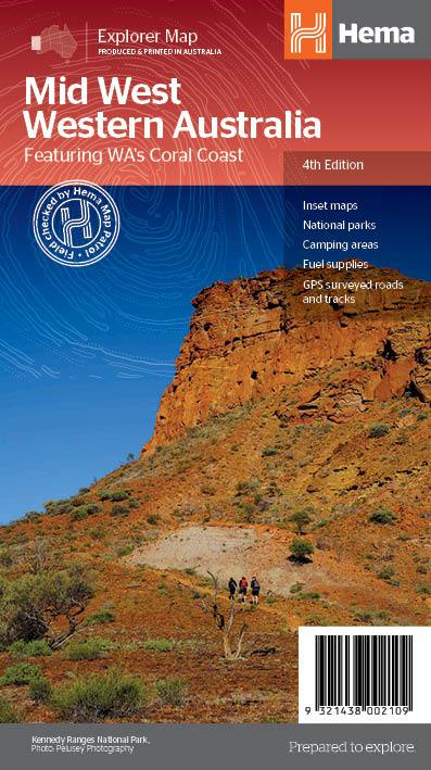
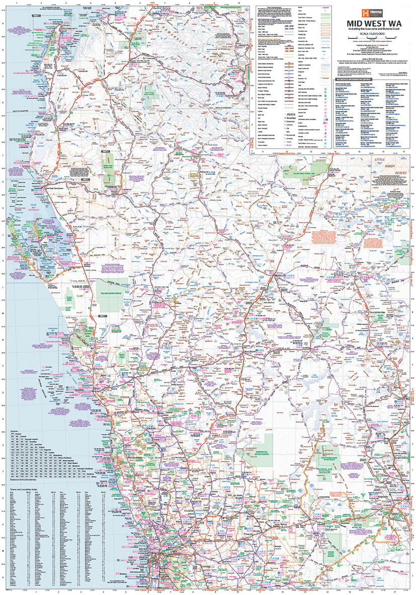
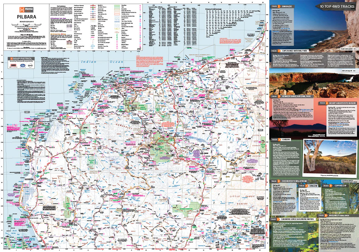
Unleash your spirit of adventure and discover the untamed beauty of Australia’s tropical north with the Top End National Parks Map by Hema, a trusted name in Australian cartography. Whether you’re planning your next 4WD expedition, creating an educational display, or dreaming of waterfalls and ancient rock art, this beautifully crafted 700 x 1000 mm laminated map is your perfect companion.
This map brings together three of Australia’s most iconic national parks — Kakadu, Litchfield, and Nitmiluk — in a single, highly detailed, easy-to-read sheet designed for travelers, educators, planners, and nature lovers alike.
🗺️ What’s on the Map?
| 🌍 Feature | 🔍 Details |
|---|---|
| 🌿 Kakadu National Park | World Heritage-listed, known for Aboriginal rock art, waterfalls, billabongs, and wildlife. |
| 🌊 Nitmiluk (Katherine Gorge) | Gorge system with canoeing, hikes, and rugged sandstone cliffs. |
| 🏞️ Litchfield National Park | Accessible waterfalls, magnetic termite mounds, and refreshing plunge pools. |
| 🛣️ Roads & Access Routes | Major access roads, 4WD tracks, river crossings, and navigation aids. |
| 🏕️ Campsites & Rest Areas | Designated camping areas, caravan stops, and day-use facilities. |
| 🛒 Services & Fuel Stops | Petrol stations, visitor centres, and accommodation options. |
| 📍 Points of Interest | Walking trails, waterfalls, natural features, Aboriginal art sites. |
| 📞 Contacts & Info | Visitor information numbers and safety advice. |
🎯 Why You’ll Love It
✅ Expertly Rendered Relief – The map uses shaded relief for a vivid representation of terrain, making topography clear and engaging.
✅ Tailored for Adventure – Whether you're paddling Katherine Gorge or crossing rugged escarpments, you’ll know exactly where to go and what to expect.
✅ Beautiful & Functional – Striking enough to hang on your wall, practical enough to take planning to the next level.
✅ Trusted Quality – From Hema Maps, Australia’s leading mapmaker for over 40 years.
🧭 Features at a Glance
-
🏕️ Camping areas
-
⛽ Fuel & service stops
-
🎒 Bushwalking & hiking trails
-
🚿 Swimming holes & waterfalls
-
🧭 Shaded relief topography
-
📍 Detailed point-of-interest labels
-
📞 Useful contacts & visitor centre info
-
🛶 Paddle routes & lookout points
-
🦎 Wildlife watching spots
-
📏 1:350,000 scale
🛡️ Laminated for Durability & Versatility
Encapsulated in high-quality 80-micron gloss laminate, this map is ideal for long-term use and interaction:
-
🖊️ Use whiteboard markers to plan, update, or personalise your journeys
-
📍 Apply map dots or symbols to mark key destinations
-
💧 Waterproof and tear-resistant — ideal for camp, classroom, or office use
-
🧳 Great for pre-trip briefings, trip logs, or decorating your travel van or office wall
💡 Note: This version is laminated from a previously folded map. Slight crease lines may still be visible.
📐 Product Specifications
| Specification | Detail |
|---|---|
| Publisher | Hema Maps |
| Edition | Latest Available |
| Scale | 1:350,000 |
| Map Coverage | Kakadu, Nitmiluk, Litchfield |
| Size | 700 mm (W) x 1000 mm (H) |
| Material | 120gsm FSC-certified base + 80-micron laminate |
| Map Format | Laminated wall map (flat) |
| Weight | Approx. 120g |
| Made In | Australia |
🧳 Who It’s For
| Audience | Why It’s Perfect For You |
|---|---|
| 🚐 4WD Travellers | Reliable detail on terrain and fuel stops |
| 🥾 Hikers & Adventurers | Trailheads, waterfalls, natural wonders all mapped out |
| 🗺️ Home & Office Decor | A beautiful wall piece for anyone who loves the Top End |
| 📚 Teachers & Students | Use as a learning tool for geography, Aboriginal culture, and conservation |
| 🧭 Planners & Tour Operators | Plan trips, tours, and logistics with ease |
🌏 Bring the Top End to Life
From towering escarpments to billabong sanctuaries, from the dreaming stories of Aboriginal custodians to the breathtaking natural beauty of Northern Australia, this map helps you visualise, understand, and explore one of the most fascinating regions on Earth.
📦 Delivery & Extras
-
✅ Rolled and shipped in a protective tube
-
🪵 Optional wooden hang rails available by request
-
⏱️ Please allow extra time for custom framing or large orders
📌 Also available in paper-only and canvas formats — contact us for options.
Original: $35.74
-65%$35.74
$12.51Product Information
Product Information
Shipping & Returns
Shipping & Returns
Description
🐊 Top End National Parks Wall Map – Laminated (Hema Maps)
Kakadu • Nitmiluk • Litchfield — The Heart of the Northern Territory in One Striking Map
Unleash your spirit of adventure and discover the untamed beauty of Australia’s tropical north with the Top End National Parks Map by Hema, a trusted name in Australian cartography. Whether you’re planning your next 4WD expedition, creating an educational display, or dreaming of waterfalls and ancient rock art, this beautifully crafted 700 x 1000 mm laminated map is your perfect companion.
This map brings together three of Australia’s most iconic national parks — Kakadu, Litchfield, and Nitmiluk — in a single, highly detailed, easy-to-read sheet designed for travelers, educators, planners, and nature lovers alike.
🗺️ What’s on the Map?
| 🌍 Feature | 🔍 Details |
|---|---|
| 🌿 Kakadu National Park | World Heritage-listed, known for Aboriginal rock art, waterfalls, billabongs, and wildlife. |
| 🌊 Nitmiluk (Katherine Gorge) | Gorge system with canoeing, hikes, and rugged sandstone cliffs. |
| 🏞️ Litchfield National Park | Accessible waterfalls, magnetic termite mounds, and refreshing plunge pools. |
| 🛣️ Roads & Access Routes | Major access roads, 4WD tracks, river crossings, and navigation aids. |
| 🏕️ Campsites & Rest Areas | Designated camping areas, caravan stops, and day-use facilities. |
| 🛒 Services & Fuel Stops | Petrol stations, visitor centres, and accommodation options. |
| 📍 Points of Interest | Walking trails, waterfalls, natural features, Aboriginal art sites. |
| 📞 Contacts & Info | Visitor information numbers and safety advice. |
🎯 Why You’ll Love It
✅ Expertly Rendered Relief – The map uses shaded relief for a vivid representation of terrain, making topography clear and engaging.
✅ Tailored for Adventure – Whether you're paddling Katherine Gorge or crossing rugged escarpments, you’ll know exactly where to go and what to expect.
✅ Beautiful & Functional – Striking enough to hang on your wall, practical enough to take planning to the next level.
✅ Trusted Quality – From Hema Maps, Australia’s leading mapmaker for over 40 years.
🧭 Features at a Glance
-
🏕️ Camping areas
-
⛽ Fuel & service stops
-
🎒 Bushwalking & hiking trails
-
🚿 Swimming holes & waterfalls
-
🧭 Shaded relief topography
-
📍 Detailed point-of-interest labels
-
📞 Useful contacts & visitor centre info
-
🛶 Paddle routes & lookout points
-
🦎 Wildlife watching spots
-
📏 1:350,000 scale
🛡️ Laminated for Durability & Versatility
Encapsulated in high-quality 80-micron gloss laminate, this map is ideal for long-term use and interaction:
-
🖊️ Use whiteboard markers to plan, update, or personalise your journeys
-
📍 Apply map dots or symbols to mark key destinations
-
💧 Waterproof and tear-resistant — ideal for camp, classroom, or office use
-
🧳 Great for pre-trip briefings, trip logs, or decorating your travel van or office wall
💡 Note: This version is laminated from a previously folded map. Slight crease lines may still be visible.
📐 Product Specifications
| Specification | Detail |
|---|---|
| Publisher | Hema Maps |
| Edition | Latest Available |
| Scale | 1:350,000 |
| Map Coverage | Kakadu, Nitmiluk, Litchfield |
| Size | 700 mm (W) x 1000 mm (H) |
| Material | 120gsm FSC-certified base + 80-micron laminate |
| Map Format | Laminated wall map (flat) |
| Weight | Approx. 120g |
| Made In | Australia |
🧳 Who It’s For
| Audience | Why It’s Perfect For You |
|---|---|
| 🚐 4WD Travellers | Reliable detail on terrain and fuel stops |
| 🥾 Hikers & Adventurers | Trailheads, waterfalls, natural wonders all mapped out |
| 🗺️ Home & Office Decor | A beautiful wall piece for anyone who loves the Top End |
| 📚 Teachers & Students | Use as a learning tool for geography, Aboriginal culture, and conservation |
| 🧭 Planners & Tour Operators | Plan trips, tours, and logistics with ease |
🌏 Bring the Top End to Life
From towering escarpments to billabong sanctuaries, from the dreaming stories of Aboriginal custodians to the breathtaking natural beauty of Northern Australia, this map helps you visualise, understand, and explore one of the most fascinating regions on Earth.
📦 Delivery & Extras
-
✅ Rolled and shipped in a protective tube
-
🪵 Optional wooden hang rails available by request
-
⏱️ Please allow extra time for custom framing or large orders
📌 Also available in paper-only and canvas formats — contact us for options.