Current Divisions | Decommunized Toponyms | Premium Finishes
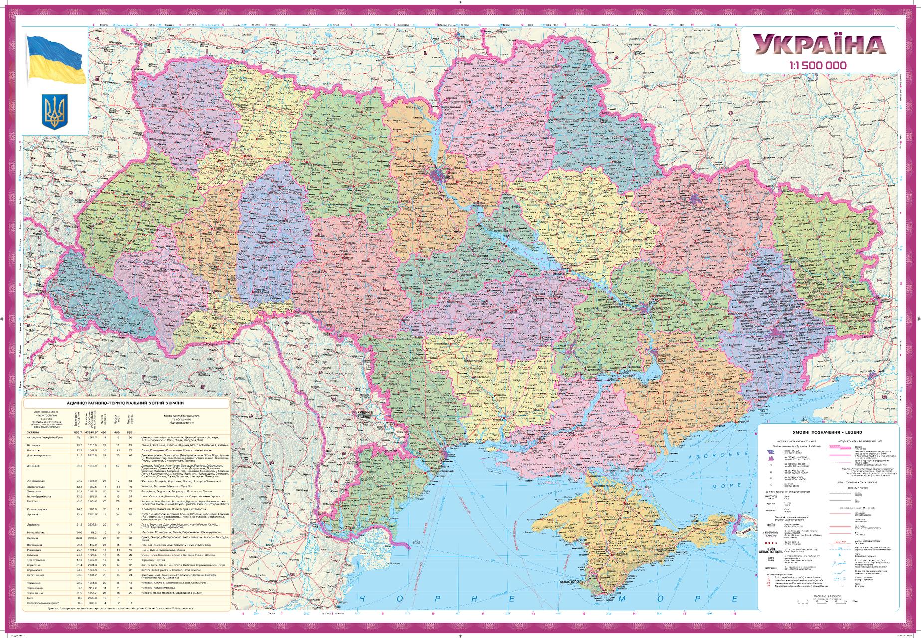
Gain a clear, authoritative view of modern Ukraine with a wall map that presents the current political and territorial structure alongside post-communism (decommunized) place names. Labels are in Ukrainian, making this an ideal reference for classrooms, offices, government and NGO settings, and anyone who needs a precise yet elegant overview of Ukraine’s administrative geography.
🗺️ Map Features
-
Complete Administrative Framework
Clear depiction of oblasts, raions, and major municipalities for fast, unambiguous orientation. -
Decommunized Toponymy (Ukrainian)
Uses modern, post-communism place names in Ukrainian for accuracy in education, policy, and professional use. -
Wall-Optimized Legibility
Balanced colour palette, disciplined boundary styling, and crisp typography deliver clarity without clutter at viewing distance. -
Capital & Regional Centres Highlighted
Kyiv and oblast centres are emphasised to anchor teaching, briefing, and planning sessions. -
Annotation-Friendly (Laminated Option)
Write on / wipe off with non-permanent markers—perfect for lessons, workshops, and strategic mapping.
✨ Available Finishes
| Format | Description |
|---|---|
| 📜 Paper (160 gsm) | Heavyweight matte-coated paper—perfect for framing under glass. |
| 🧼 Laminated (Encapsulated) | Fully sealed in 80-micron gloss laminate for a durable, wipe-clean surface. |
| 🪵 Laminated with Wooden Hang Rails | Laminated map mounted with lacquered natural timber rails (top & bottom) and a hanging cord—ready to display. |
| 🖼️ Canvas (395 gsm) | Printed on HP Professional Matte Canvas with archival pigment-based inks—rich texture, fade-resistant, gallery quality. |
| 🪵 Canvas with Wooden Hang Rails | Canvas finished with lacquered timber rails and a hanging cord—no framing required for a timeless presentation. |
🔨 Hang-railed maps are made to order—please allow up to 10 working days for professional mounting.
📐 Specifications
| Feature | Detail |
|---|---|
| Title | Ukraine Political & Administrative Wall Map (in Ukrainian) |
| Map Type | Political / Administrative |
| Language | Ukrainian (decommunized toponymy) |
| Scale | 1:1,500,000 |
| Dimensions | 966 mm (W) × 666 mm (H) |
| Orientation | Landscape |
| Materials | Paper, Laminated, Canvas, With or Without Timber Rails |
| Printing | Pigment-based inks, fade-resistant |
💡 Why You’ll Love This Map
-
Authoritative snapshot of Ukraine’s current administrative landscape.
-
Accurate, decommunized place names for modern educational and professional contexts.
-
Clean, display-ready design that elevates meeting rooms, classrooms, and home offices.
-
Five premium finishes to fit usage—from everyday workspaces to gallery-grade display.
🚚 Delivery
-
Paper, Laminated, and Canvas (rolled): Usually ships within 1–2 business days.
-
Hang-railed versions: Made to order; allow up to 10 working days.
-
Packaging: Securely protected to arrive in pristine condition.
Put Ukraine’s governance structure in sharp focus. Mount this precise, Ukrainian-language reference and give every discussion—academic, civic, or strategic—a rock-solid geographic foundation.


