Ukraine Political and Administrative Wall Map 1380 x 950 mm (in Ukrainian)
Large-Format | Current Divisions | Premium Finishes
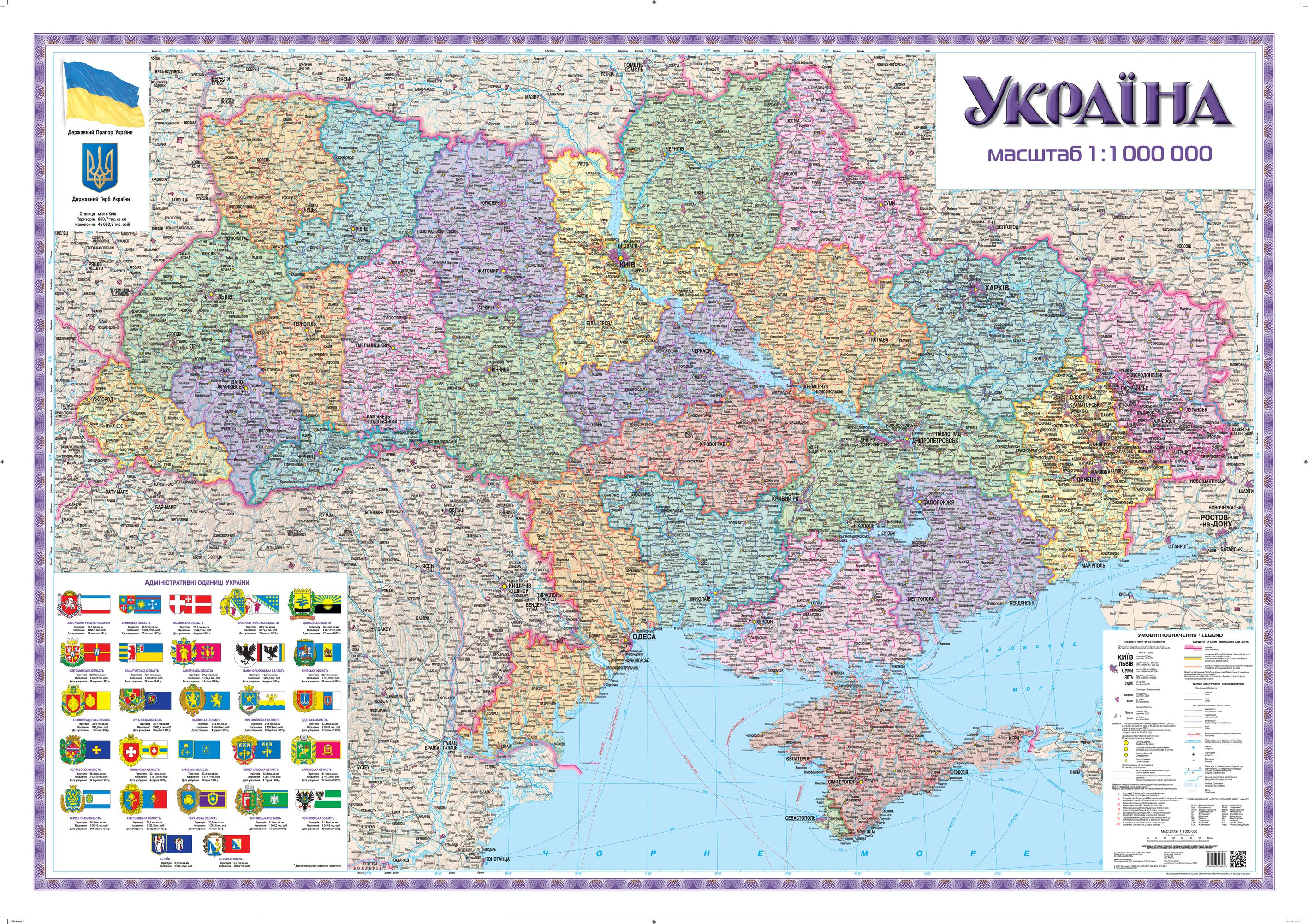
Understand modern Ukraine at a glance. This large Ukrainian-language wall map presents the current political and territorial structure—including oblasts, raions, and cities of oblast significance—with modern place names for clear, authoritative reference. Perfect for classrooms, offices, government spaces, NGOs, and anyone who needs a precise, wall-readable overview of Ukraine’s administrative geography.
🗺️ Map Features
-
Comprehensive Administrative Coverage
Clearly delineated oblasts, raions, and cities of oblast significance (territories subordinated to cities of oblast subordinance) for unambiguous jurisdictional understanding. -
Modern Toponymy (Ukrainian)
All labels presented in Ukrainian, using contemporary place names to ensure accuracy and relevance. -
Clear Hierarchy & Colour Coding
Disciplined boundary styling, intuitive colour palette, and legible typography deliver clarity at wall distance. -
Capital & Oblast Centres
Kyiv and oblast capitals highlighted for fast orientation and instructional use. -
Wall-Optimised Cartography
Clean legend, balanced labels, and high-resolution reproduction provide clarity without clutter in meeting rooms and classrooms alike. -
Annotation-Friendly (Laminated Option)
Write on / wipe off with non-permanent markers—ideal for lessons, briefings, and project planning.
✨ Available Finishes
| Format | Description |
|---|---|
| 📜 Paper (160 gsm) | Heavyweight matte-coated paper—perfect for framing under glass. |
| 🧼 Laminated (Encapsulated) | Fully sealed in 80-micron gloss laminate for a durable, wipe-clean surface. |
| 🪵 Laminated with Wooden Hang Rails | Laminated map mounted with lacquered natural timber rails (top & bottom) and a hanging cord—ready to display. |
| 🖼️ Canvas (395 gsm) | Printed on HP Professional Matte Canvas with archival pigment-based inks—rich texture, fade-resistant, gallery quality. |
| 🪵 Canvas with Wooden Hang Rails | Canvas finished with lacquered timber rails and hanging cord—no framing required for a timeless presentation. |
🔨 Hang-railed maps are made to order—please allow up to 10 working days for professional mounting.
📐 Specifications
| Feature | Detail |
|---|---|
| Title | Ukraine Political & Administrative Wall Map (in Ukrainian) |
| Map Type | Political / Administrative |
| Language | Ukrainian |
| Scale | 1:1,000,000 |
| Dimensions | 1380 mm (W) × 950 mm (H) |
| Orientation | Landscape |
| Materials | Paper, Laminated, Canvas, With or Without Timber Rails |
| Printing | Pigment-based inks, fade-resistant |
💡 Why You’ll Love This Map
-
Authoritative snapshot of Ukraine’s administrative structure in one clear view.
-
Ukrainian-language labels for authenticity in education and professional settings.
-
Display-ready design that elevates conference rooms, classrooms, and home offices.
-
Flexible finishes—from frame-ready paper to gallery-grade canvas and ready-to-hang rail options.
🚚 Delivery
-
Paper, Laminated, and Canvas (rolled): Usually ships within 1–2 business days.
-
Hang-railed versions: Made to order; allow up to 10 working days.
-
Packaging: Securely protected to arrive in pristine condition.
Make Ukraine’s governance structure instantly understandable. Mount this precise, Ukrainian-language reference and give every discussion—academic, civic, or professional—a clear geographic foundation.
Original: $71.51
-65%$71.51
$25.03Product Information
Product Information
Shipping & Returns
Shipping & Returns
Description
Large-Format | Current Divisions | Premium Finishes
Understand modern Ukraine at a glance. This large Ukrainian-language wall map presents the current political and territorial structure—including oblasts, raions, and cities of oblast significance—with modern place names for clear, authoritative reference. Perfect for classrooms, offices, government spaces, NGOs, and anyone who needs a precise, wall-readable overview of Ukraine’s administrative geography.
🗺️ Map Features
-
Comprehensive Administrative Coverage
Clearly delineated oblasts, raions, and cities of oblast significance (territories subordinated to cities of oblast subordinance) for unambiguous jurisdictional understanding. -
Modern Toponymy (Ukrainian)
All labels presented in Ukrainian, using contemporary place names to ensure accuracy and relevance. -
Clear Hierarchy & Colour Coding
Disciplined boundary styling, intuitive colour palette, and legible typography deliver clarity at wall distance. -
Capital & Oblast Centres
Kyiv and oblast capitals highlighted for fast orientation and instructional use. -
Wall-Optimised Cartography
Clean legend, balanced labels, and high-resolution reproduction provide clarity without clutter in meeting rooms and classrooms alike. -
Annotation-Friendly (Laminated Option)
Write on / wipe off with non-permanent markers—ideal for lessons, briefings, and project planning.
✨ Available Finishes
| Format | Description |
|---|---|
| 📜 Paper (160 gsm) | Heavyweight matte-coated paper—perfect for framing under glass. |
| 🧼 Laminated (Encapsulated) | Fully sealed in 80-micron gloss laminate for a durable, wipe-clean surface. |
| 🪵 Laminated with Wooden Hang Rails | Laminated map mounted with lacquered natural timber rails (top & bottom) and a hanging cord—ready to display. |
| 🖼️ Canvas (395 gsm) | Printed on HP Professional Matte Canvas with archival pigment-based inks—rich texture, fade-resistant, gallery quality. |
| 🪵 Canvas with Wooden Hang Rails | Canvas finished with lacquered timber rails and hanging cord—no framing required for a timeless presentation. |
🔨 Hang-railed maps are made to order—please allow up to 10 working days for professional mounting.
📐 Specifications
| Feature | Detail |
|---|---|
| Title | Ukraine Political & Administrative Wall Map (in Ukrainian) |
| Map Type | Political / Administrative |
| Language | Ukrainian |
| Scale | 1:1,000,000 |
| Dimensions | 1380 mm (W) × 950 mm (H) |
| Orientation | Landscape |
| Materials | Paper, Laminated, Canvas, With or Without Timber Rails |
| Printing | Pigment-based inks, fade-resistant |
💡 Why You’ll Love This Map
-
Authoritative snapshot of Ukraine’s administrative structure in one clear view.
-
Ukrainian-language labels for authenticity in education and professional settings.
-
Display-ready design that elevates conference rooms, classrooms, and home offices.
-
Flexible finishes—from frame-ready paper to gallery-grade canvas and ready-to-hang rail options.
🚚 Delivery
-
Paper, Laminated, and Canvas (rolled): Usually ships within 1–2 business days.
-
Hang-railed versions: Made to order; allow up to 10 working days.
-
Packaging: Securely protected to arrive in pristine condition.
Make Ukraine’s governance structure instantly understandable. Mount this precise, Ukrainian-language reference and give every discussion—academic, civic, or professional—a clear geographic foundation.


