United States of America 1968 Wall Map by National Geographic
Interstates, Air Routes & Outlying Areas — United States of America Wall Map (1968)
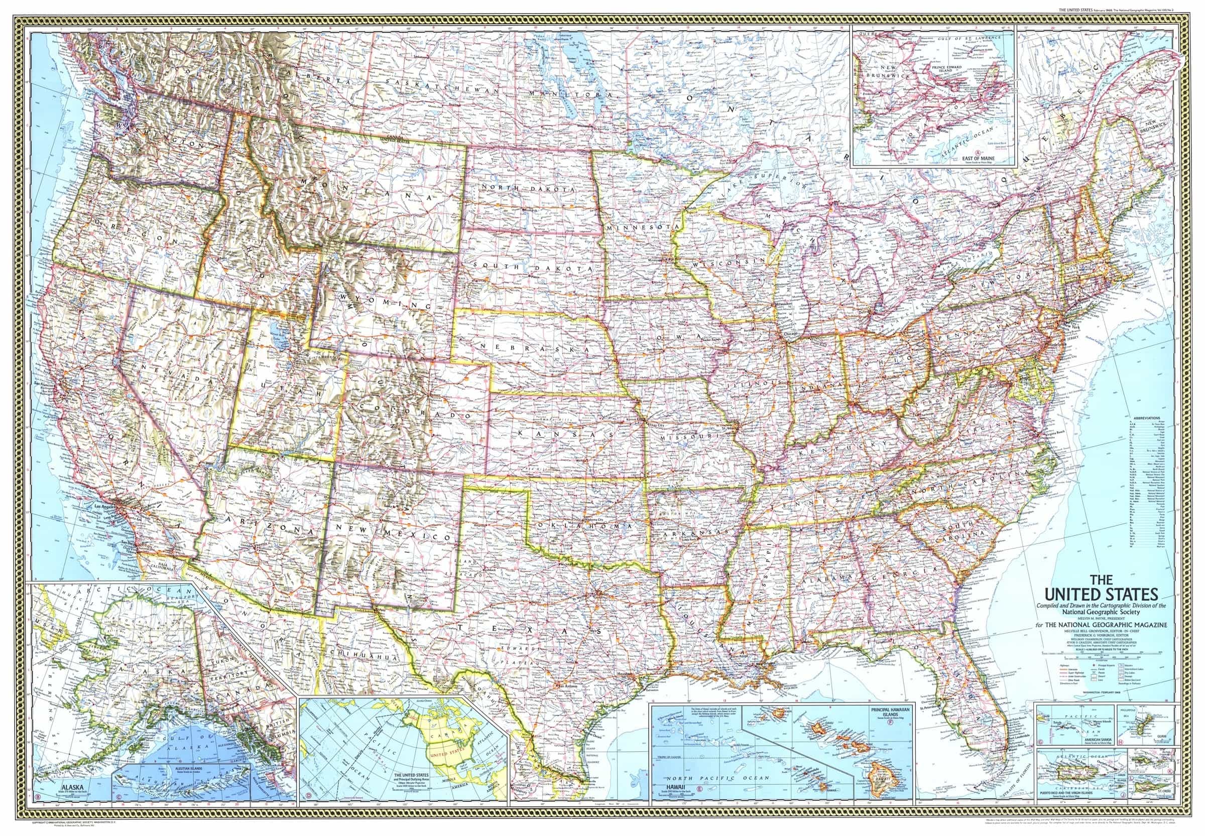
A snapshot of America in the high-Interstate era, rendered with clarity and restraint. Published by National Geographic in February 1968 (updating the July 1961 edition), this U.S. sheet layers expanding freeways, scheduled air service, and expressive relief shading over dense, legible place naming. Thoughtful insets for Alaska, Hawai‘i, and the principal outlying areas complete a design that’s as informative as it is beautiful—made to study, admire, and display.
More Than a Map – A Testament to History
This isn’t just wall art—it’s the networked nation at mid-century. Read Interstates and major roads (including under-construction segments), scan rivers, lakes, mountain ranges and elevations, and spot missile tracking stations alongside air-service hubs. Ideal for educators, planners, historians, designers, and collectors, it pairs perfectly with earlier (1946) and later (1970s–80s) U.S. maps for a compelling then-and-now display.
Hang it in studios, libraries, classrooms, museums, offices, or at home to invite reflection, study, and conversation.
Premium Materials & Finishes
We treat history with the respect it deserves. That’s why we offer multiple formats, each produced using high-quality materials and modern archival printing.
🌟 Archival Paper Print
Printed on heavyweight 160gsm archival-grade paper.
Smooth matte finish reduces glare and preserves fine linework and labels.
Ideal for framing under glass—clean, timeless, and built to last.
💎 Laminated Edition
Encapsulated in two sheets of 80-micron gloss laminate using true thermal bonding—not just surface lamination.
Moisture-resistant, wipe-clean surface—perfect for classrooms and high-traffic reference spaces.
Optional Natural Timber Hang Rails: lacquered rails with a fitted hanging cord—ready to display. (Please allow up to 10 working days for delivery with hang rails.)
🏆 Museum-Quality Canvas
Printed on heavyweight 395gsm HP Professional Matte Canvas for rich texture and exceptional strength.
Pigment-based, fade-resistant inks deliver deep tone and crisp typography that endure for generations.
Optional Natural Timber Hang Rails: lacquered to enhance the grain; top cord for effortless hanging—elegant in any setting. (Please allow up to 10 working days for delivery with hang rails.)
Specifications
| Feature | Details |
|---|---|
| Title | United States of America Wall Map |
| Series | National Geographic single-sheet U.S. map |
| Original Publication | 1968 (February; update to the July 1961 U.S. map) |
| Scale | 1:4,561,920 |
| Cartographic Content | All 50 states (with insets for Alaska & Hawai‘i); thousands of place names incl. capitals, cities & towns; relief-shaded mountain ranges; Interstates & major roads (incl. under-construction freeways); rivers, lakes, elevations; stars for scheduled air service; icons for missile tracking stations; inset of U.S. & principal outlying areas; insets for American Samoa, Guam, Puerto Rico & the U.S. Virgin Islands (St. Croix, St. Thomas, St. John) |
| Map Size | 1078 mm (W) × 748 mm (H) |
| Available Formats | Paper, Laminated, Canvas |
| Paper Weight | 160gsm archival-quality |
| Laminate | 2 × 80-micron gloss laminate sheets (encapsulated) |
| Canvas Weight | 395gsm HP Professional Matte Canvas |
| Inks | Pigment-based, fade-resistant |
| Optional Hang Rails | Available on Laminated & Canvas (lead time up to 10 working days) |
| Origin | Made in Australia |
Why Choose This Map
✔ Era-True Snapshot: The Interstate boom captured at a pivotal moment in 1968.
✔ Layered Insight: Highways, air service, and missile tracking icons convey movement and defense.
✔ Nation & Territories: Clear insets for Alaska, Hawai‘i, and U.S. outlying areas.
✔ Clarity at Scale: Crisp labels and relief shading read beautifully near or far.
✔ Archival Craft: Premium substrates and inks preserve contrast, labels, and linework for decades.
Our Commitment
We believe that preserving history is as important as telling it. Every map is printed locally in Australia using state-of-the-art technology, carefully checked by hand, and packed with care. From the moment it leaves our workshop to the day it hangs on your wall, we ensure quality you can trust and a legacy you’ll be proud to share.
See America’s network knit together. Order the United States of America (1968) today—a faithful, beautifully produced sheet that turns a room into a conversation.
Original: $50.05
-65%$50.05
$17.52Product Information
Product Information
Shipping & Returns
Shipping & Returns
Description
Interstates, Air Routes & Outlying Areas — United States of America Wall Map (1968)
A snapshot of America in the high-Interstate era, rendered with clarity and restraint. Published by National Geographic in February 1968 (updating the July 1961 edition), this U.S. sheet layers expanding freeways, scheduled air service, and expressive relief shading over dense, legible place naming. Thoughtful insets for Alaska, Hawai‘i, and the principal outlying areas complete a design that’s as informative as it is beautiful—made to study, admire, and display.
More Than a Map – A Testament to History
This isn’t just wall art—it’s the networked nation at mid-century. Read Interstates and major roads (including under-construction segments), scan rivers, lakes, mountain ranges and elevations, and spot missile tracking stations alongside air-service hubs. Ideal for educators, planners, historians, designers, and collectors, it pairs perfectly with earlier (1946) and later (1970s–80s) U.S. maps for a compelling then-and-now display.
Hang it in studios, libraries, classrooms, museums, offices, or at home to invite reflection, study, and conversation.
Premium Materials & Finishes
We treat history with the respect it deserves. That’s why we offer multiple formats, each produced using high-quality materials and modern archival printing.
🌟 Archival Paper Print
Printed on heavyweight 160gsm archival-grade paper.
Smooth matte finish reduces glare and preserves fine linework and labels.
Ideal for framing under glass—clean, timeless, and built to last.
💎 Laminated Edition
Encapsulated in two sheets of 80-micron gloss laminate using true thermal bonding—not just surface lamination.
Moisture-resistant, wipe-clean surface—perfect for classrooms and high-traffic reference spaces.
Optional Natural Timber Hang Rails: lacquered rails with a fitted hanging cord—ready to display. (Please allow up to 10 working days for delivery with hang rails.)
🏆 Museum-Quality Canvas
Printed on heavyweight 395gsm HP Professional Matte Canvas for rich texture and exceptional strength.
Pigment-based, fade-resistant inks deliver deep tone and crisp typography that endure for generations.
Optional Natural Timber Hang Rails: lacquered to enhance the grain; top cord for effortless hanging—elegant in any setting. (Please allow up to 10 working days for delivery with hang rails.)
Specifications
| Feature | Details |
|---|---|
| Title | United States of America Wall Map |
| Series | National Geographic single-sheet U.S. map |
| Original Publication | 1968 (February; update to the July 1961 U.S. map) |
| Scale | 1:4,561,920 |
| Cartographic Content | All 50 states (with insets for Alaska & Hawai‘i); thousands of place names incl. capitals, cities & towns; relief-shaded mountain ranges; Interstates & major roads (incl. under-construction freeways); rivers, lakes, elevations; stars for scheduled air service; icons for missile tracking stations; inset of U.S. & principal outlying areas; insets for American Samoa, Guam, Puerto Rico & the U.S. Virgin Islands (St. Croix, St. Thomas, St. John) |
| Map Size | 1078 mm (W) × 748 mm (H) |
| Available Formats | Paper, Laminated, Canvas |
| Paper Weight | 160gsm archival-quality |
| Laminate | 2 × 80-micron gloss laminate sheets (encapsulated) |
| Canvas Weight | 395gsm HP Professional Matte Canvas |
| Inks | Pigment-based, fade-resistant |
| Optional Hang Rails | Available on Laminated & Canvas (lead time up to 10 working days) |
| Origin | Made in Australia |
Why Choose This Map
✔ Era-True Snapshot: The Interstate boom captured at a pivotal moment in 1968.
✔ Layered Insight: Highways, air service, and missile tracking icons convey movement and defense.
✔ Nation & Territories: Clear insets for Alaska, Hawai‘i, and U.S. outlying areas.
✔ Clarity at Scale: Crisp labels and relief shading read beautifully near or far.
✔ Archival Craft: Premium substrates and inks preserve contrast, labels, and linework for decades.
Our Commitment
We believe that preserving history is as important as telling it. Every map is printed locally in Australia using state-of-the-art technology, carefully checked by hand, and packed with care. From the moment it leaves our workshop to the day it hangs on your wall, we ensure quality you can trust and a legacy you’ll be proud to share.
See America’s network knit together. Order the United States of America (1968) today—a faithful, beautifully produced sheet that turns a room into a conversation.


