Victoria Geological Map (1977)
1977 — State of Victoria
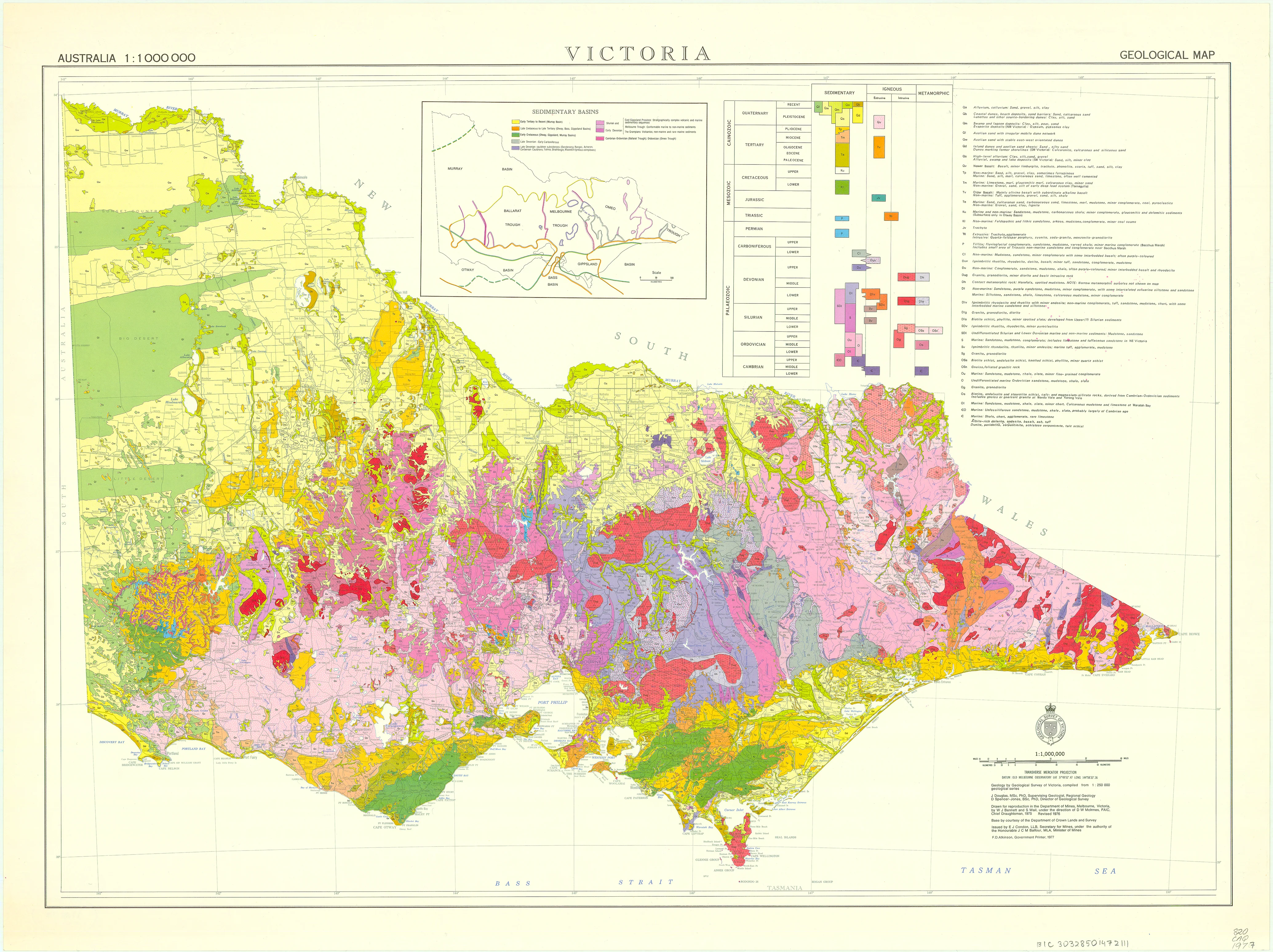
Victoria Geological Map (Australia 1:1 000 000 Series)
Official Geological Survey Map
This authoritative 1977 geological map of Victoria forms part of Australia’s nationally recognised 1:1 000 000 geological mapping series, prepared by the Geological Survey of Victoria and reproduced through the Department of Mines, Melbourne. Drawn by W. J. Bennett and S. Wail under the direction of D. W. McInnes, it represents a culmination of decades of coordinated fieldwork, laboratory analysis, and interpretive synthesis across the state.
Conceived as a working scientific document, the map balances breadth and clarity: it distils Victoria’s complex geology into a coherent statewide overview while retaining the precision required for professional use. The result is a map that is equally at home in a research lab, lecture theatre, planning office, or serious private collection.
🪨 What the Map Shows
-
Statewide geological framework of Victoria at a uniform 1:1 000 000 scale
-
Major rock groups and ages, clearly differentiated through a systematic colour palette
-
Sedimentary basins, igneous provinces, and metamorphic belts presented as continuous regional systems
-
Key structural relationships that explain how Victoria’s geology fits within the broader Australian continent
Rather than focusing on local detail, the map excels at regional understanding—revealing patterns that only emerge when the whole state is viewed at once.
📜 Historical & Scientific Context
By 1977, Australian geology had entered a mature interpretive phase. Advances in radiometric dating, stratigraphic correlation, and plate-tectonic theory allowed geologists to reassess long-standing assumptions about the age and origin of rock formations. Victoria—geologically diverse despite its relatively small size—became a proving ground for these new frameworks.
This map captures that moment. Ancient Palaeozoic fold belts, gold-bearing terrains, younger sedimentary sequences, and extensive volcanic provinces are integrated into a single, authoritative narrative. For historians of science, it marks a period when geological mapping shifted from purely descriptive survey work toward continent-scale synthesis.
As a result, the map is not just a reference—it is a historical document reflecting how Victoria’s geology was understood at the close of the twentieth century’s most influential geological reforms.
🧭 Cartographic Character & Design
-
Produced to professional geological survey standards
-
Clear hierarchy of colour, linework, and typography optimised for wall-scale reading
-
Designed for interpretation and comparison, not decoration
-
Exemplifies late-20th-century Australian scientific cartography—precise, restrained, and purpose-driven
This is cartography as applied science: maps created to support exploration, policy, education, and long-term land understanding.
✨ Premium Print & Display Options
Each copy is printed in Australia using archival processes to preserve the original colour relationships, line precision, and tonal balance of the 1977 survey.
| Finish | Description |
|---|---|
| 📄 Heavyweight Paper (160 gsm matte) | Archival matte surface with crisp colour separation and excellent legibility. |
| 🔒 Laminated (True Encapsulation) | Sealed between 2 × 80-micron gloss laminate; tear-resistant, wipe-clean, and durable. |
| 🎨 Archival Canvas (395 gsm HP Professional Matte) | Pigment-based, fade-resistant inks with strong visual presence and depth. |
| 🪵 Laminated + Timber Hang Rails | Natural lacquered timber rails, ready to hang (allow up to 10 working days). |
| 🪵 Canvas + Timber Hang Rails | Gallery-ready, frame-free finish (allow up to 10 working days). |
📐 Size (W × H)
-
1000 mm × 750 mm
-
Orientation: Landscape
-
Custom sizing: Available on request
🎯 Ideal For
-
Earth science and geology departments
-
Mining, exploration, and environmental consultancies
-
Universities, schools, and technical colleges
-
Government planning and resource agencies
-
Collectors of Australian scientific and government maps
🤝 Our Commitment
Printed locally in Australia, every map is carefully colour-managed, inspected, and packed to ensure it faithfully reflects the authority, clarity, and intent of the original 1977 Geological Survey of Victoria issue.
A disciplined, authoritative portrait of Victoria’s deep geological structure—where science, history, and cartography meet at statewide scale.
Original: $64.36
-65%$64.36
$22.53Product Information
Product Information
Shipping & Returns
Shipping & Returns
Description
1977 — State of Victoria
Victoria Geological Map (Australia 1:1 000 000 Series)
Official Geological Survey Map
This authoritative 1977 geological map of Victoria forms part of Australia’s nationally recognised 1:1 000 000 geological mapping series, prepared by the Geological Survey of Victoria and reproduced through the Department of Mines, Melbourne. Drawn by W. J. Bennett and S. Wail under the direction of D. W. McInnes, it represents a culmination of decades of coordinated fieldwork, laboratory analysis, and interpretive synthesis across the state.
Conceived as a working scientific document, the map balances breadth and clarity: it distils Victoria’s complex geology into a coherent statewide overview while retaining the precision required for professional use. The result is a map that is equally at home in a research lab, lecture theatre, planning office, or serious private collection.
🪨 What the Map Shows
-
Statewide geological framework of Victoria at a uniform 1:1 000 000 scale
-
Major rock groups and ages, clearly differentiated through a systematic colour palette
-
Sedimentary basins, igneous provinces, and metamorphic belts presented as continuous regional systems
-
Key structural relationships that explain how Victoria’s geology fits within the broader Australian continent
Rather than focusing on local detail, the map excels at regional understanding—revealing patterns that only emerge when the whole state is viewed at once.
📜 Historical & Scientific Context
By 1977, Australian geology had entered a mature interpretive phase. Advances in radiometric dating, stratigraphic correlation, and plate-tectonic theory allowed geologists to reassess long-standing assumptions about the age and origin of rock formations. Victoria—geologically diverse despite its relatively small size—became a proving ground for these new frameworks.
This map captures that moment. Ancient Palaeozoic fold belts, gold-bearing terrains, younger sedimentary sequences, and extensive volcanic provinces are integrated into a single, authoritative narrative. For historians of science, it marks a period when geological mapping shifted from purely descriptive survey work toward continent-scale synthesis.
As a result, the map is not just a reference—it is a historical document reflecting how Victoria’s geology was understood at the close of the twentieth century’s most influential geological reforms.
🧭 Cartographic Character & Design
-
Produced to professional geological survey standards
-
Clear hierarchy of colour, linework, and typography optimised for wall-scale reading
-
Designed for interpretation and comparison, not decoration
-
Exemplifies late-20th-century Australian scientific cartography—precise, restrained, and purpose-driven
This is cartography as applied science: maps created to support exploration, policy, education, and long-term land understanding.
✨ Premium Print & Display Options
Each copy is printed in Australia using archival processes to preserve the original colour relationships, line precision, and tonal balance of the 1977 survey.
| Finish | Description |
|---|---|
| 📄 Heavyweight Paper (160 gsm matte) | Archival matte surface with crisp colour separation and excellent legibility. |
| 🔒 Laminated (True Encapsulation) | Sealed between 2 × 80-micron gloss laminate; tear-resistant, wipe-clean, and durable. |
| 🎨 Archival Canvas (395 gsm HP Professional Matte) | Pigment-based, fade-resistant inks with strong visual presence and depth. |
| 🪵 Laminated + Timber Hang Rails | Natural lacquered timber rails, ready to hang (allow up to 10 working days). |
| 🪵 Canvas + Timber Hang Rails | Gallery-ready, frame-free finish (allow up to 10 working days). |
📐 Size (W × H)
-
1000 mm × 750 mm
-
Orientation: Landscape
-
Custom sizing: Available on request
🎯 Ideal For
-
Earth science and geology departments
-
Mining, exploration, and environmental consultancies
-
Universities, schools, and technical colleges
-
Government planning and resource agencies
-
Collectors of Australian scientific and government maps
🤝 Our Commitment
Printed locally in Australia, every map is carefully colour-managed, inspected, and packed to ensure it faithfully reflects the authority, clarity, and intent of the original 1977 Geological Survey of Victoria issue.
A disciplined, authoritative portrait of Victoria’s deep geological structure—where science, history, and cartography meet at statewide scale.


