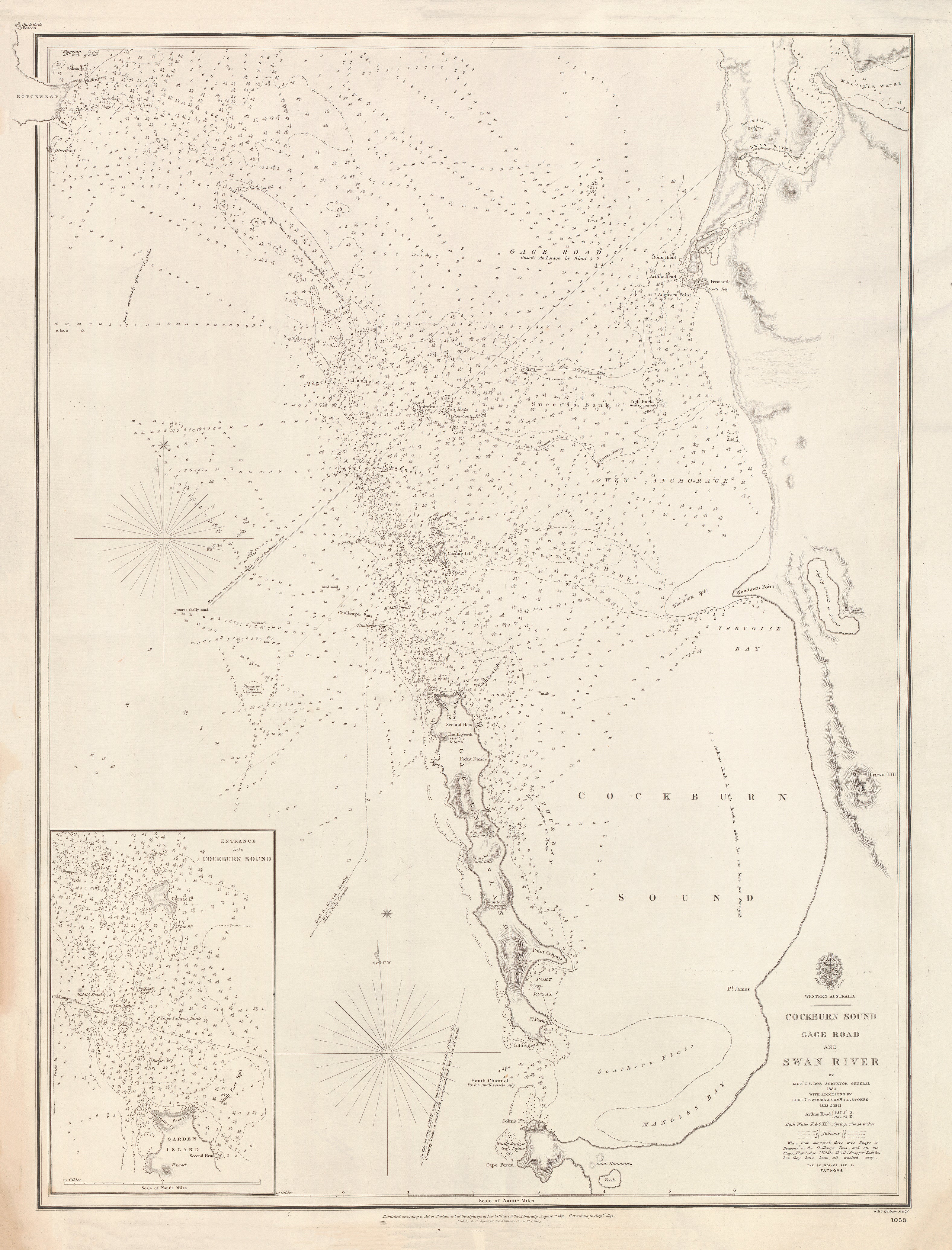
Western Australia — Cockburn Sound, Gage Roads & Swan River (1830–1841)
The Admiralty chart that shaped Perth’s maritime gateway
This superb British Admiralty chart records the moment Western Australia’s principal harbour approaches were first unified into a single, authoritative navigation sheet. Originally surveyed in 1830 by John Septimus Roe—later Western Australia’s first Surveyor General—and updated through 1841 by Thomas Woore and John Lort Stokes, it captures Cockburn Sound, Gage Roads, and the entrance to the Swan River as they became safe, legible approaches for colonial shipping.
Engraved by J. & C. Walker and published by the British Admiralty, this was the working chart that underpinned Perth’s early maritime life—anchorage selection, pilotage, and river access.
This is not a decorative map.
It is the blueprint of Perth’s harbour approaches.
⚓ What This Chart Shows
This finely engraved Admiralty sheet delivers harbour-scale precision:
-
Cockburn Sound with anchorages and approaches
-
Gage Roads — the principal outer anchorage
-
Entrance to the Swan River, the settlement’s lifeline
-
Inset: Entrance into Cockburn Sound at enlarged scale
-
Bathymetric soundings and isolines showing depths and hazards
-
Coastal relief rendered with classic Admiralty hachures
-
Greenwich prime meridian — true naval reference standard
🧭 Why This Chart Works
Most maps show where a harbour is.
This shows how ships actually used it.
-
Authored by John Septimus Roe, a foundational figure in WA surveying
-
Updated by Stokes and Woore, linking early settlement to mature hydrography
-
True British Admiralty production — the global benchmark for accuracy
-
High-resolution harbour detail essential for pilotage and anchoring
-
Museum-grade engraving by J. & C. Walker
✨ Premium Finishes
Printed in Australia using archival methods to preserve the fine engraving and historic tone.
| Format | Description |
|---|---|
| 📜 Paper (160 gsm matte) | Smooth heavyweight archival paper with crisp line definition; ideal for framing under glass. |
| 🧼 Laminated (True Encapsulation) | 2 × 80-micron gloss laminate, edge-to-edge protection; tear-resistant and wipe-clean. |
| 🖼️ Canvas (395 gsm HP Professional Matte) | Pigment-based, fade-resistant inks for a warm, gallery-grade finish. |
| 🪵 Laminated + Timber Hang Rails | Natural timber rails with hanging cord; ready to hang. Allow up to 10 working days. |
| 🪵 Canvas + Timber Hang Rails | Elegant frameless presentation with lacquered natural timber rails. Allow up to 10 working days. |
📐 Size (W × H)
760 mm × 1000 mm
Orientation: Portrait
Aspect ratio: ~0.76 : 1
This tall format emphasises the north–south alignment of Cockburn Sound and the Swan River entrance.
Framing tips: If framing under glass, allow a 2–3 mm mat overlap; alternatively, float-mount with a ~3 mm reveal for a gallery look.
Custom sizing: Available on request.
🎯 Ideal For
-
Western Australian maritime history collectors
-
Perth and Fremantle heritage interiors
-
Museums, libraries and universities
-
Yacht clubs, ports and coastal institutions
🤝 Our Commitment
-
Printed in Australia with professional colour management
-
Archival pigment inks for long-term colour stability
-
Premium laminates and canvas for durability
-
Natural timber hang rails for refined presentation
-
Hand-checked and carefully packed before dispatch
Before Fremantle became a port city, these waters were charted here.
Choose your finish and bring Perth’s foundational harbour map onto your wall.