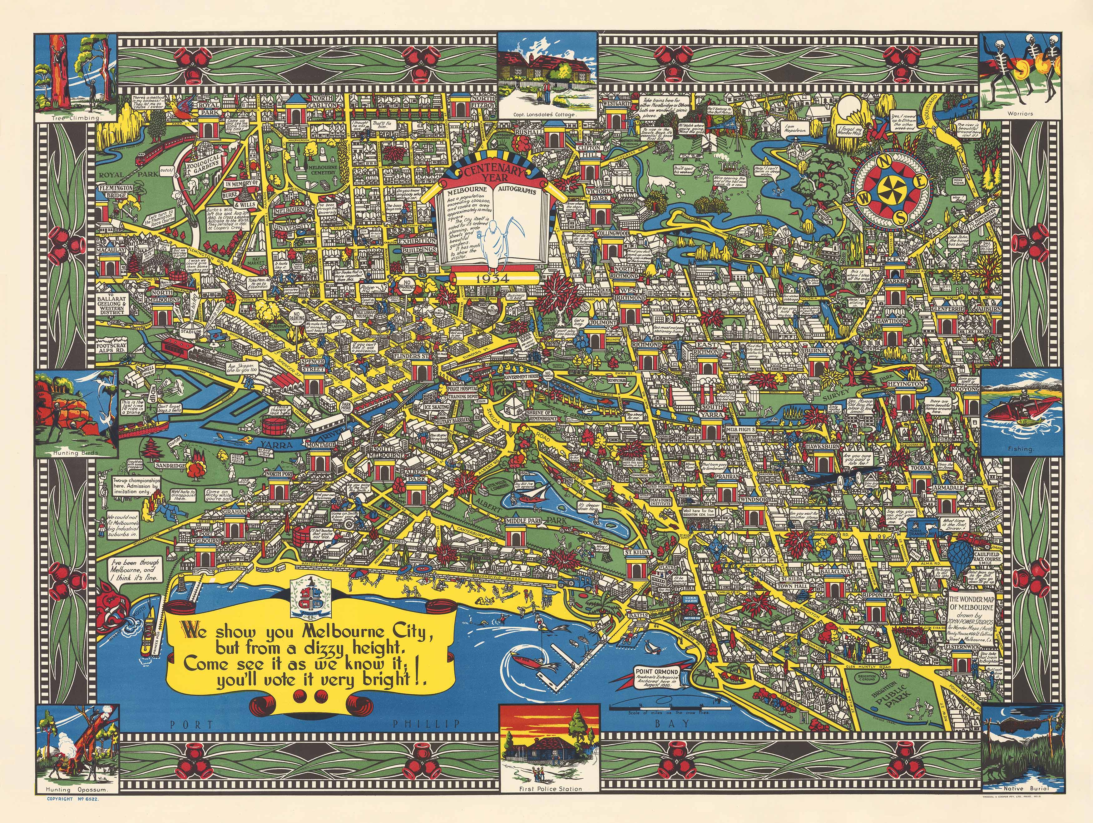
Wonder Map of Melbourne 1934
A whimsical, richly illustrated view of 1930s Melbourne with wit, charm, and social satire.
Step into a delightfully illustrated version of Melbourne as imagined in 1934, with the Wonder Map of Melbourne by John Power Studios. More than just a map, this is a vivid tapestry of city life—part cartography, part caricature, and part social commentary.
Originally created for promotional purposes during Melbourne’s interwar boom, the map depicts the city and its suburbs in an ornate, hand-drawn style. The characters that populate its corners and captions are straight out of a Monopoly board—bowler hats, bustle skirts, and all. Every element, from the lush, velvety grass to the winding roads and stylised landmarks, is infused with humour and artistic flair.
Beneath its playful illustrations lies a sharp wit. Power’s captions and caricatures gently poke fun at the politics, pretensions, and preoccupations of Melburnians in the 1930s. It’s a map that invites you not only to explore a city, but to eavesdrop on its culture, its quirks, and its characters.
Key Features:
-
Published: 1934
-
Cartographer/Illustrator: John Power Studios
-
Style: Pictorial map with whimsical illustrations, humorous captions, and rich visual texture
-
Depicts: Central Melbourne and surrounding suburbs as viewed through a satirical 1930s lens
-
Cultural Note: A rare example of Depression-era Australian graphic design and social commentary
Finish Options:
| Finish | Description |
|---|---|
| Paper (160 gsm) | Perfect for traditional framing under glass. Printed on heavyweight, museum-grade paper stock. |
| Laminated | Gloss encapsulated with two sheets of 80-micron laminate. Durable, water-resistant, and wipeable—ideal for classrooms or public spaces. |
| Canvas (395 gsm HP Matte) | Printed with pigment-based archival inks on premium matte canvas. Rich in colour and exceptionally long-lasting—designed to impress in homes, galleries, or offices. |
Optional Hang Rails :
Canvas versions can be supplied with natural timber hang rails top and bottom, complete with a matching hanging cord. This is the easiest way to display your map without the need for traditional framing—just add a hook and hang.
Please note: Allow up to 10 working days for delivery if selecting a hang-railed finish, as these are hand-assembled by our professional framer.
Map Size:
950 mm (W) x 720 mm (H)
Why Choose the Wonder Map of Melbourne?
This is no ordinary street map—it’s a playful, pointed snapshot of a past era, full of hidden jokes, brilliant visual touches, and exquisite design. Whether you’re a proud Melburnian, a map collector, or a lover of 20th-century art and design, the Wonder Map of Melbourne makes a striking and conversation-starting addition to any wall.
Original: $57.20
-65%$57.20
$20.02Product Information
Product Information
Shipping & Returns
Shipping & Returns
Description
A whimsical, richly illustrated view of 1930s Melbourne with wit, charm, and social satire.
Step into a delightfully illustrated version of Melbourne as imagined in 1934, with the Wonder Map of Melbourne by John Power Studios. More than just a map, this is a vivid tapestry of city life—part cartography, part caricature, and part social commentary.
Originally created for promotional purposes during Melbourne’s interwar boom, the map depicts the city and its suburbs in an ornate, hand-drawn style. The characters that populate its corners and captions are straight out of a Monopoly board—bowler hats, bustle skirts, and all. Every element, from the lush, velvety grass to the winding roads and stylised landmarks, is infused with humour and artistic flair.
Beneath its playful illustrations lies a sharp wit. Power’s captions and caricatures gently poke fun at the politics, pretensions, and preoccupations of Melburnians in the 1930s. It’s a map that invites you not only to explore a city, but to eavesdrop on its culture, its quirks, and its characters.
Key Features:
-
Published: 1934
-
Cartographer/Illustrator: John Power Studios
-
Style: Pictorial map with whimsical illustrations, humorous captions, and rich visual texture
-
Depicts: Central Melbourne and surrounding suburbs as viewed through a satirical 1930s lens
-
Cultural Note: A rare example of Depression-era Australian graphic design and social commentary
Finish Options:
| Finish | Description |
|---|---|
| Paper (160 gsm) | Perfect for traditional framing under glass. Printed on heavyweight, museum-grade paper stock. |
| Laminated | Gloss encapsulated with two sheets of 80-micron laminate. Durable, water-resistant, and wipeable—ideal for classrooms or public spaces. |
| Canvas (395 gsm HP Matte) | Printed with pigment-based archival inks on premium matte canvas. Rich in colour and exceptionally long-lasting—designed to impress in homes, galleries, or offices. |
Optional Hang Rails :
Canvas versions can be supplied with natural timber hang rails top and bottom, complete with a matching hanging cord. This is the easiest way to display your map without the need for traditional framing—just add a hook and hang.
Please note: Allow up to 10 working days for delivery if selecting a hang-railed finish, as these are hand-assembled by our professional framer.
Map Size:
950 mm (W) x 720 mm (H)
Why Choose the Wonder Map of Melbourne?
This is no ordinary street map—it’s a playful, pointed snapshot of a past era, full of hidden jokes, brilliant visual touches, and exquisite design. Whether you’re a proud Melburnian, a map collector, or a lover of 20th-century art and design, the Wonder Map of Melbourne makes a striking and conversation-starting addition to any wall.


