World Physical Mega Map 2200 x 1270mm (Pacific Centred) Cosmographics 2026
Cosmographics | 2026 Edition
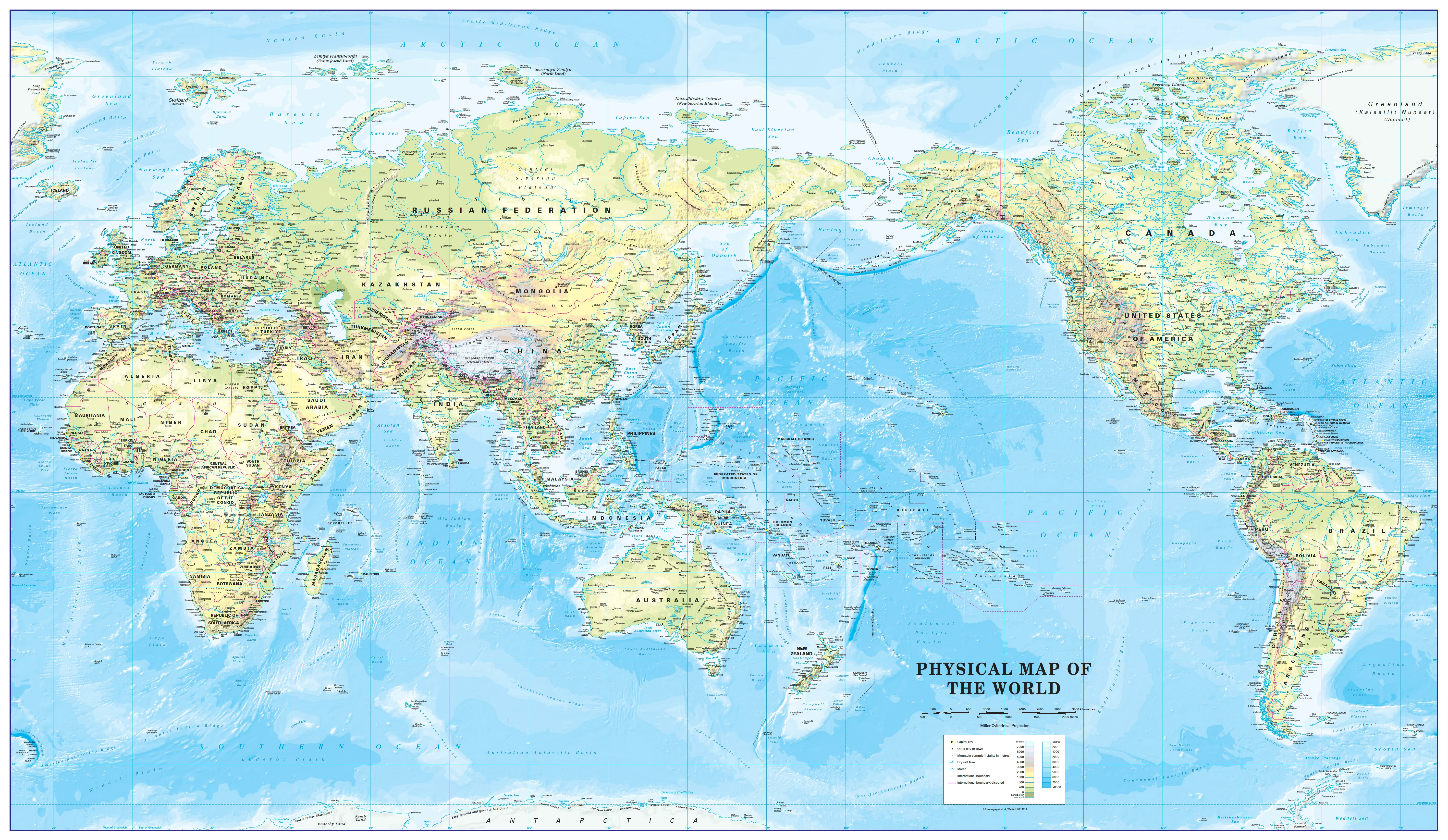
Scale: 1:20,000,000
Formats: Paper, Laminated, or Canvas | Optional Timber Hang Rails for Laminated & Canvas Versions
A Monumental Map for a Global Perspective
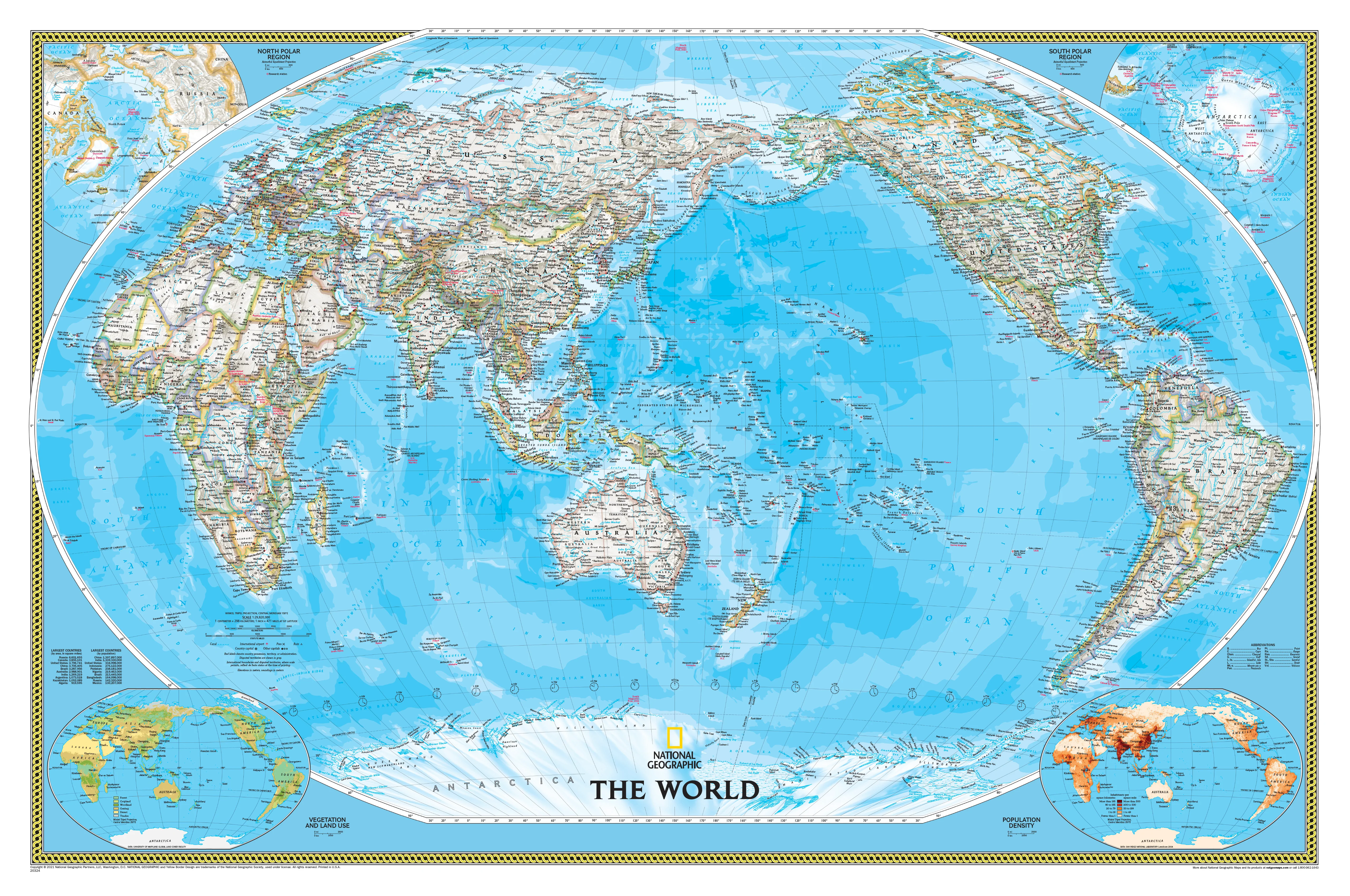
Discover the world in stunning detail with the World Physical Mega Map by Cosmographics, now updated for 2026 and centred on the Pacific Ocean. At over 2 metres wide, this large-format map provides a fresh orientation that places Australia, New Zealand, and the Asia-Pacific at the heart of global geography—perfect for classrooms, offices, and map lovers who want to see the world from a new angle.
With its Miller Cylindrical projection, this map delivers minimal distortion and a true sense of scale—making it both visually impressive and geographically informative. Mountains, basins, deserts, rivers, forests, and deep-sea trenches are all represented with subtle but vivid shading, alongside clearly defined country borders and major world cities.
Whether you're planning a lesson, a journey, or simply admiring the layout of the Earth, this map is both aesthetic and practical—a true centrepiece of cartographic craftsmanship.
🌐 Map Features
-
Pacific-Centred Design
Say goodbye to Africa-centred conventions—this map reflects a Pacific view of the world, ideal for Australians, Kiwis, and Asia-Pacific users. -
Physical Terrain & Topography
Every continent is rendered in nuanced natural colours, showing elevation, landforms, deserts, ice caps, and vegetative zones. -
Ocean Bathymetry
Ocean depths are visualised using graduated blue tones, revealing underwater features such as trenches, mid-ocean ridges, and continental shelves. -
Political Borders
Countries are outlined and colour-differentiated with tasteful contrasts that don’t overpower the physical geography. -
Cities and Capitals
Major cities, capitals, and international boundaries are all clearly marked.
🖨️ Format Options
This map is available in three distinct formats to suit different needs and display environments:
| Format | Material & Use |
|---|---|
| Paper (160gsm) | A smooth matte paper ideal for framing under glass. Lightweight and cost-effective, with excellent detail clarity. |
| Laminated | Fully encapsulated in 80-micron gloss laminate, allowing whiteboard-marker use. Waterproof, tear-resistant, and ideal for schools and offices. |
| Canvas | Printed on 395gsm HP Professional Matte Canvas using long-life pigment-based inks. Fade-resistant, elegant, and suitable for display without glass. |
🪵 Optional Hang Rails (Laminated & Canvas Only)
For an elegant display, we offer the option to add wooden hang rails to both laminated and canvas versions.
-
Top and bottom rails made from lacquered natural timber
-
Includes a hanging cord pre-attached to the top rail
-
Ready to hang—simply place on a hook or nail
⏳ Please allow up to 10 working days for delivery when hang rails are selected, as each is hand-finished by our professional framer.
📏 Map Specifications
| Feature | Details |
|---|---|
| Publisher | Cosmographics |
| Published | 2026 |
| Projection | Miller Cylindrical |
| Orientation | Pacific-Centred |
| Scale | 1:20,000,000 |
| Map Size | 2200 mm (W) x 1270 mm (H) |
| Material Options | Paper / Laminated / Canvas |
| Optional Hang Rails | Available for Laminated & Canvas only |
| Printed in | Australia |
🎯 Who Is This Map For?
-
Educators & Classrooms
Visualise physical geography, teach global scale, and foster geographic literacy in a striking, engaging way. -
Professionals & Planners
Use it in boardrooms, planning departments, or government settings to anchor presentations and discussions. -
Homes & Decor
Make a statement in your study, living room, or hallway—this map is as much art as it is reference. -
Travellers & Students
Fuel curiosity and understanding of the world. Mark journeys, plan trips, or simply marvel at Earth's complexity. -
Gifting
A refined and impressive gift for teachers, travellers, students, geographers, or anyone with a global view.
🛒 How to Order
Use the dropdown menus above to:
-
Select your preferred format: Paper, Laminated, or Canvas.
-
Choose whether you’d like to add Timber Hang Rails (available for laminated and canvas versions).
🚚 Delivery Notes
-
Hang-railed maps require up to 10 working days for finishing.
-
Mega-size maps are shipped via courier only – please provide a physical address (no PO Boxes).
Original: $286.15
-65%$286.15
$100.15Product Information
Product Information
Shipping & Returns
Shipping & Returns
Description
Cosmographics | 2026 Edition
Scale: 1:20,000,000
Formats: Paper, Laminated, or Canvas | Optional Timber Hang Rails for Laminated & Canvas Versions
A Monumental Map for a Global Perspective
Discover the world in stunning detail with the World Physical Mega Map by Cosmographics, now updated for 2026 and centred on the Pacific Ocean. At over 2 metres wide, this large-format map provides a fresh orientation that places Australia, New Zealand, and the Asia-Pacific at the heart of global geography—perfect for classrooms, offices, and map lovers who want to see the world from a new angle.
With its Miller Cylindrical projection, this map delivers minimal distortion and a true sense of scale—making it both visually impressive and geographically informative. Mountains, basins, deserts, rivers, forests, and deep-sea trenches are all represented with subtle but vivid shading, alongside clearly defined country borders and major world cities.
Whether you're planning a lesson, a journey, or simply admiring the layout of the Earth, this map is both aesthetic and practical—a true centrepiece of cartographic craftsmanship.
🌐 Map Features
-
Pacific-Centred Design
Say goodbye to Africa-centred conventions—this map reflects a Pacific view of the world, ideal for Australians, Kiwis, and Asia-Pacific users. -
Physical Terrain & Topography
Every continent is rendered in nuanced natural colours, showing elevation, landforms, deserts, ice caps, and vegetative zones. -
Ocean Bathymetry
Ocean depths are visualised using graduated blue tones, revealing underwater features such as trenches, mid-ocean ridges, and continental shelves. -
Political Borders
Countries are outlined and colour-differentiated with tasteful contrasts that don’t overpower the physical geography. -
Cities and Capitals
Major cities, capitals, and international boundaries are all clearly marked.
🖨️ Format Options
This map is available in three distinct formats to suit different needs and display environments:
| Format | Material & Use |
|---|---|
| Paper (160gsm) | A smooth matte paper ideal for framing under glass. Lightweight and cost-effective, with excellent detail clarity. |
| Laminated | Fully encapsulated in 80-micron gloss laminate, allowing whiteboard-marker use. Waterproof, tear-resistant, and ideal for schools and offices. |
| Canvas | Printed on 395gsm HP Professional Matte Canvas using long-life pigment-based inks. Fade-resistant, elegant, and suitable for display without glass. |
🪵 Optional Hang Rails (Laminated & Canvas Only)
For an elegant display, we offer the option to add wooden hang rails to both laminated and canvas versions.
-
Top and bottom rails made from lacquered natural timber
-
Includes a hanging cord pre-attached to the top rail
-
Ready to hang—simply place on a hook or nail
⏳ Please allow up to 10 working days for delivery when hang rails are selected, as each is hand-finished by our professional framer.
📏 Map Specifications
| Feature | Details |
|---|---|
| Publisher | Cosmographics |
| Published | 2026 |
| Projection | Miller Cylindrical |
| Orientation | Pacific-Centred |
| Scale | 1:20,000,000 |
| Map Size | 2200 mm (W) x 1270 mm (H) |
| Material Options | Paper / Laminated / Canvas |
| Optional Hang Rails | Available for Laminated & Canvas only |
| Printed in | Australia |
🎯 Who Is This Map For?
-
Educators & Classrooms
Visualise physical geography, teach global scale, and foster geographic literacy in a striking, engaging way. -
Professionals & Planners
Use it in boardrooms, planning departments, or government settings to anchor presentations and discussions. -
Homes & Decor
Make a statement in your study, living room, or hallway—this map is as much art as it is reference. -
Travellers & Students
Fuel curiosity and understanding of the world. Mark journeys, plan trips, or simply marvel at Earth's complexity. -
Gifting
A refined and impressive gift for teachers, travellers, students, geographers, or anyone with a global view.
🛒 How to Order
Use the dropdown menus above to:
-
Select your preferred format: Paper, Laminated, or Canvas.
-
Choose whether you’d like to add Timber Hang Rails (available for laminated and canvas versions).
🚚 Delivery Notes
-
Hang-railed maps require up to 10 working days for finishing.
-
Mega-size maps are shipped via courier only – please provide a physical address (no PO Boxes).