World Political Large with Flags 1021 x 706mm (Pacific Centred) Cosmographics 2026
World Political Map with Flags — Cosmographics (2026)
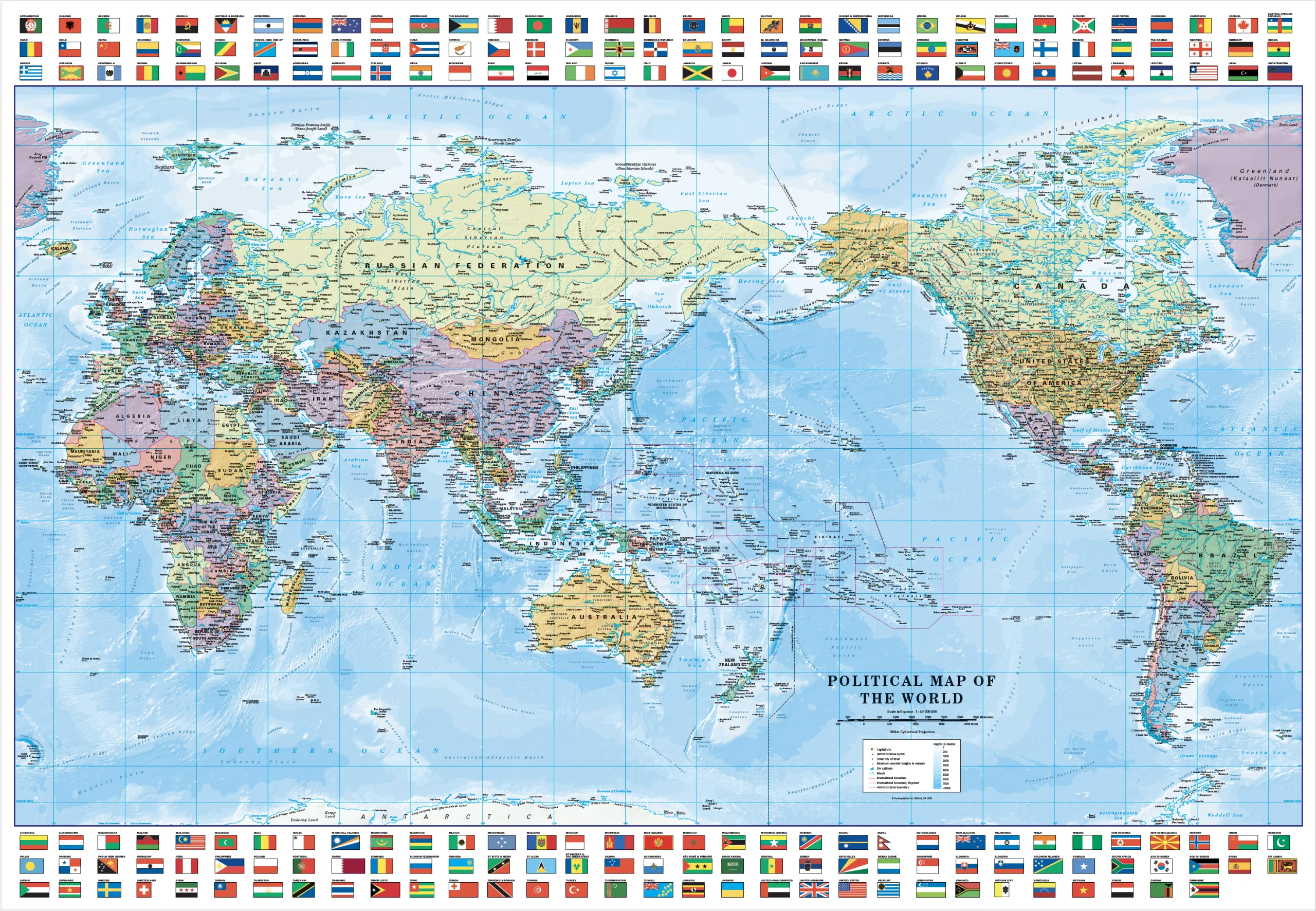
Pacific-Centred World Map | Countries, Capitals & Flags | 1021 × 706 mm | Premium Finishes
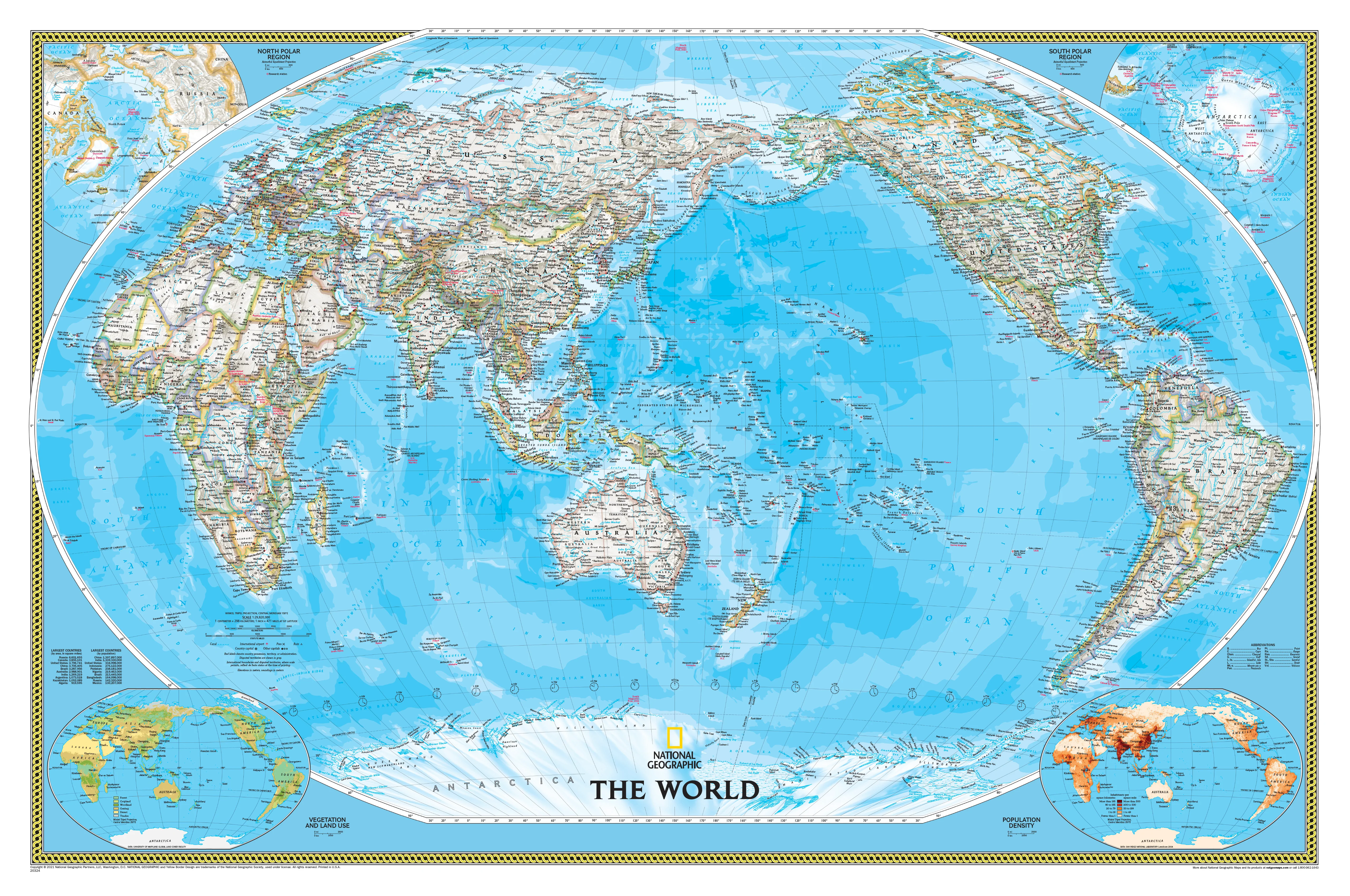
A clean, highly readable view of the modern world, the World Political Map with Flags by Cosmographics brings global geography into sharp focus. Centred on the Pacific, it offers a perspective that places Australia and the Asia-Pacific region front and centre—ideal for local classrooms, offices, and homes.
With every nation clearly defined and paired with its flag, this map balances clarity, education, and visual appeal in a versatile large-format size.
Why This Map Stands Out
Pacific-centred perspective
A modern world view ideal for Australian and Asia-Pacific audiences.
Flags for every country
Quick visual identification and strong educational value.
Clear political mapping
Countries, borders, and capitals presented with precision.
Large-format readability
Generous size without overwhelming wall space.
A practical everyday map
Perfect for reference, learning, and display.
🌍 What the Map Shows
🗺️ Global Political Detail
- All countries clearly defined with borders
- Capital cities prominently labelled
- Major towns and geographic reference points included
🚩 World Flags
- National flags displayed alongside their respective countries
- Easy visual reference for global identity
- Ideal for classrooms and general knowledge
🌏 Pacific-Centred Layout
- The Pacific Ocean positioned centrally
- Continuous view from the Americas to Asia and Oceania
- A more intuitive layout for Southern Hemisphere users
⛰️ Physical Features
- Major mountain ranges and rivers
- Oceans and seabed relief for added depth
- A balanced mix of political and physical geography
🌐 A Map That Works Everywhere
Designed to be both functional and visually engaging, this map helps you:
- Understand global relationships at a glance
- Identify countries and capitals quickly
- Teach and learn geography effectively
- Add a clean, informative focal point to any wall
📐 Size & Format
1021 mm (W) × 706 mm (H)
Landscape orientation
A versatile size ideal for:
- Classrooms and study areas
- Offices and workspaces
- Home walls and learning environments
- Smaller spaces needing a clear world reference
✨ Premium Finishes & Display Options
Every World Political Map with Flags (2026) is produced using archival-grade materials and precision colour management, ensuring sharp detail and long-lasting colour.
📜 Heavyweight Paper (160 gsm Matte)
Classic. Refined. Frame-ready.
- Premium 160 gsm matte-coated archival paper
- Smooth, low-glare surface for easy reading
- Ideal for framing under glass
💡 Best for: traditional display and detailed study.
🧼 Laminated (True Encapsulation — 2 × 80 Micron Gloss)
Durable. Practical. Built to last.
- Fully sealed with 2 × 80-micron laminate
- Edge-to-edge protection against wear and moisture
- Wipe-clean surface for notes and markers
💡 Best for: classrooms and active use.
🪵 Laminated + Timber Hang Rails
Ready to hang. Clean lines. Contemporary feel.
- Natural timber rails (top & bottom), lacquered finish
- Includes hanging cord
- Keeps map flat without framing
🔨 Please allow up to 10 working days.
💡 Best for: offices and ready-to-hang display.
🖼️ Archival Canvas (395 gsm HP Professional Matte)
Textured. Elegant. Gallery-quality.
- Printed on 395 gsm HP Professional Matte Canvas
- Pigment-based inks for long-term colour stability
- Subtle texture enhances visual depth
💡 Best for: feature walls and premium interiors.
🪵 Canvas + Timber Hang Rails
Gallery-ready. Warm. Architectural.
- Canvas paired with natural timber rails
- Clean, balanced presentation
🔨 Please allow up to 10 working days.
💡 Best for: statement display spaces.
📊 Specifications
| Feature | Detail |
|---|---|
| Title | World Political Map with Flags |
| Publisher | Cosmographics |
| Edition | 2026 |
| Dimensions | 1021 mm × 706 mm |
| Orientation | Landscape |
| Map Type | Political |
| Projection | Pacific-centred |
| Features | Flags, capitals, major cities, physical features |
| Materials | 160 gsm matte paper · 2 × 80-micron laminate · 395 gsm HP Professional Matte Canvas |
| Inks | Pigment-based, fade-resistant |
| Origin | Printed in Australia |
🎯 Ideal For
- Schools and educators teaching world geography
- Offices needing a clear global reference
- Homes wanting a practical and attractive wall map
- Students learning countries and flags
- Gift buyers looking for a useful and engaging map
🌏 A Fresh Perspective on the World
By centring the Pacific, this map reshapes how we see global geography—bringing Australia and its neighbours into focus while maintaining a complete, connected world view.
It’s designed to be:
- Clear and easy to read
- Relevant to modern audiences
- Perfect for everyday use
🤝 Our Commitment
- Printed in Australia using premium materials
- Designed for clarity, durability, and long-term use
- Carefully colour-managed for accuracy and vibrancy
- Each map is hand-checked and packed with care
🚚 Delivery
- Rolled (Paper, Laminated, Canvas): Dispatch within 1–2 business days
- Hang-Railed Finishes: Made to order — allow up to 10 working days
See the world your way—
a clear, modern map that brings countries, flags, and continents together on your wall.
Original: $50.05
-65%$50.05
$17.52Product Information
Product Information
Shipping & Returns
Shipping & Returns
Description
World Political Map with Flags — Cosmographics (2026)
Pacific-Centred World Map | Countries, Capitals & Flags | 1021 × 706 mm | Premium Finishes
A clean, highly readable view of the modern world, the World Political Map with Flags by Cosmographics brings global geography into sharp focus. Centred on the Pacific, it offers a perspective that places Australia and the Asia-Pacific region front and centre—ideal for local classrooms, offices, and homes.
With every nation clearly defined and paired with its flag, this map balances clarity, education, and visual appeal in a versatile large-format size.
Why This Map Stands Out
Pacific-centred perspective
A modern world view ideal for Australian and Asia-Pacific audiences.
Flags for every country
Quick visual identification and strong educational value.
Clear political mapping
Countries, borders, and capitals presented with precision.
Large-format readability
Generous size without overwhelming wall space.
A practical everyday map
Perfect for reference, learning, and display.
🌍 What the Map Shows
🗺️ Global Political Detail
- All countries clearly defined with borders
- Capital cities prominently labelled
- Major towns and geographic reference points included
🚩 World Flags
- National flags displayed alongside their respective countries
- Easy visual reference for global identity
- Ideal for classrooms and general knowledge
🌏 Pacific-Centred Layout
- The Pacific Ocean positioned centrally
- Continuous view from the Americas to Asia and Oceania
- A more intuitive layout for Southern Hemisphere users
⛰️ Physical Features
- Major mountain ranges and rivers
- Oceans and seabed relief for added depth
- A balanced mix of political and physical geography
🌐 A Map That Works Everywhere
Designed to be both functional and visually engaging, this map helps you:
- Understand global relationships at a glance
- Identify countries and capitals quickly
- Teach and learn geography effectively
- Add a clean, informative focal point to any wall
📐 Size & Format
1021 mm (W) × 706 mm (H)
Landscape orientation
A versatile size ideal for:
- Classrooms and study areas
- Offices and workspaces
- Home walls and learning environments
- Smaller spaces needing a clear world reference
✨ Premium Finishes & Display Options
Every World Political Map with Flags (2026) is produced using archival-grade materials and precision colour management, ensuring sharp detail and long-lasting colour.
📜 Heavyweight Paper (160 gsm Matte)
Classic. Refined. Frame-ready.
- Premium 160 gsm matte-coated archival paper
- Smooth, low-glare surface for easy reading
- Ideal for framing under glass
💡 Best for: traditional display and detailed study.
🧼 Laminated (True Encapsulation — 2 × 80 Micron Gloss)
Durable. Practical. Built to last.
- Fully sealed with 2 × 80-micron laminate
- Edge-to-edge protection against wear and moisture
- Wipe-clean surface for notes and markers
💡 Best for: classrooms and active use.
🪵 Laminated + Timber Hang Rails
Ready to hang. Clean lines. Contemporary feel.
- Natural timber rails (top & bottom), lacquered finish
- Includes hanging cord
- Keeps map flat without framing
🔨 Please allow up to 10 working days.
💡 Best for: offices and ready-to-hang display.
🖼️ Archival Canvas (395 gsm HP Professional Matte)
Textured. Elegant. Gallery-quality.
- Printed on 395 gsm HP Professional Matte Canvas
- Pigment-based inks for long-term colour stability
- Subtle texture enhances visual depth
💡 Best for: feature walls and premium interiors.
🪵 Canvas + Timber Hang Rails
Gallery-ready. Warm. Architectural.
- Canvas paired with natural timber rails
- Clean, balanced presentation
🔨 Please allow up to 10 working days.
💡 Best for: statement display spaces.
📊 Specifications
| Feature | Detail |
|---|---|
| Title | World Political Map with Flags |
| Publisher | Cosmographics |
| Edition | 2026 |
| Dimensions | 1021 mm × 706 mm |
| Orientation | Landscape |
| Map Type | Political |
| Projection | Pacific-centred |
| Features | Flags, capitals, major cities, physical features |
| Materials | 160 gsm matte paper · 2 × 80-micron laminate · 395 gsm HP Professional Matte Canvas |
| Inks | Pigment-based, fade-resistant |
| Origin | Printed in Australia |
🎯 Ideal For
- Schools and educators teaching world geography
- Offices needing a clear global reference
- Homes wanting a practical and attractive wall map
- Students learning countries and flags
- Gift buyers looking for a useful and engaging map
🌏 A Fresh Perspective on the World
By centring the Pacific, this map reshapes how we see global geography—bringing Australia and its neighbours into focus while maintaining a complete, connected world view.
It’s designed to be:
- Clear and easy to read
- Relevant to modern audiences
- Perfect for everyday use
🤝 Our Commitment
- Printed in Australia using premium materials
- Designed for clarity, durability, and long-term use
- Carefully colour-managed for accuracy and vibrancy
- Each map is hand-checked and packed with care
🚚 Delivery
- Rolled (Paper, Laminated, Canvas): Dispatch within 1–2 business days
- Hang-Railed Finishes: Made to order — allow up to 10 working days
See the world your way—
a clear, modern map that brings countries, flags, and continents together on your wall.