World Political Mega Map with Flags 2150 x 1475mm (Pacific Centred) Cosmographics 2026
Pacific-Centred World Map | Countries, Capitals & Flags | Mega Format 2150 × 1475 mm | Premium Finishes
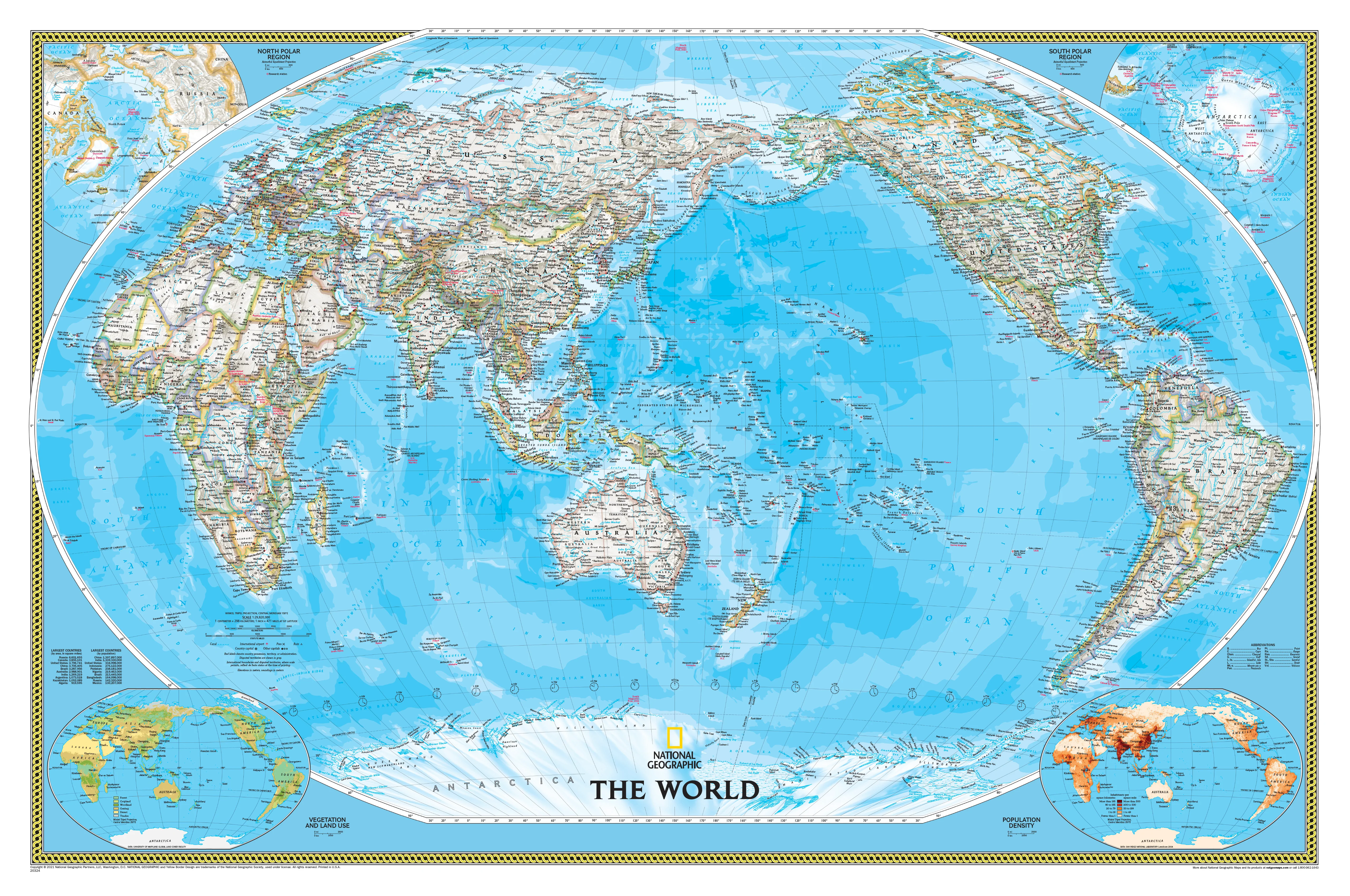
A true wall-dominating centrepiece, the World Political Mega Map with Flags by Cosmographics transforms global geography into a commanding, high-impact visual experience. At an impressive 2150 × 1475 mm, this mega-format edition delivers exceptional clarity, making it ideal for large spaces where detail and presence matter.
Centred on the Pacific, it places Australia and the Asia-Pacific region front and centre—offering a perspective that feels natural and highly relevant for Australian homes, offices, and classrooms.
Why This Map Stands Out
Mega-scale impact
An expansive 2.15 metre-wide format—designed to be seen, read, and admired from across the room.
Pacific-centred world view
A modern layout that connects the Americas, Asia, and Oceania seamlessly.
Flags for every nation
Instant visual recognition of countries and global identity.
Crisp political clarity
Borders, capitals, and major cities presented with precision.
A true statement piece
Combines functionality with striking wall presence.
🌍 What the Map Shows
🗺️ Global Political Detail
- Clearly defined international borders
- Capital cities and major urban centres
- Comprehensive place-name coverage for global reference
🚩 World Flags
- National flags aligned with their respective countries
- A powerful educational tool for visual learning
- Ideal for classrooms, offices, and global teams
🌏 Pacific-Centred Layout
- The Pacific Ocean positioned at the centre
- Continuous mapping from the Americas to Asia and Oceania
- A more intuitive view for Southern Hemisphere users
⛰️ Physical Features
- Major mountain ranges and river systems
- Oceans and seabed relief adding depth
- A balanced combination of political and physical geography
🌐 Built for Large Spaces
This is a map designed for environments where scale matters:
- Boardrooms and corporate offices
- Classrooms and lecture theatres
- Government and planning environments
- Feature walls in homes or studios
It’s not just a map—it’s a visual anchor for the room.
📐 Size & Format
2150 mm (W) × 1475 mm (H)
Mega format | Landscape orientation
A premium large-scale map ideal for:
- High-visibility wall display
- Collaborative planning spaces
- Educational environments
- Interior statement design
✨ Premium Finishes & Display Options
Every World Political Mega Map with Flags (2026) is produced using archival-grade materials and precision colour management, ensuring exceptional clarity at this large scale.
📜 Heavyweight Paper (130 gsm Matte)
Classic. Refined. Frame-ready.
- Premium 130 gsm matte-coated archival paper
- Smooth, low-glare surface enhances readability at scale
- Ideal for framing or mounting
💡 Best for: large framed installations and detailed study.
🧼 Laminated (True Encapsulation — 2 × 80 Micron Gloss)
Durable. Practical. Built to last.
- Fully sealed with 2 × 80-micron laminate
- Edge-to-edge protection across the entire surface
- Wipe-clean for markers, planning, and annotations
💡 Best for: offices, planning rooms, and classrooms.
🪵 Laminated + Timber Hang Rails
Ready to hang. Clean lines. Contemporary feel.
- Natural timber rails (top & bottom), lacquered finish
- Includes hanging cord
- Keeps the large format flat and tensioned
🔨 Please allow up to 10 working days.
💡 Best for: immediate installation in large spaces.
🖼️ Archival Canvas (395 gsm HP Professional Matte)
Textured. Elegant. Gallery-quality.
- Printed on 395 gsm HP Professional Matte Canvas
- Pigment-based inks for long-term durability
- Subtle texture enhances colour and depth
💡 Best for: premium interiors and feature walls.
🪵 Canvas + Timber Hang Rails
Gallery-ready. Warm. Architectural.
- Canvas paired with natural timber rails
- Balanced, refined presentation without framing
🔨 Please allow up to 10 working days.
💡 Best for: statement installations and design-led spaces.
Original: $286.15
-65%$286.15
$100.15Product Information
Product Information
Shipping & Returns
Shipping & Returns
Description
Pacific-Centred World Map | Countries, Capitals & Flags | Mega Format 2150 × 1475 mm | Premium Finishes
A true wall-dominating centrepiece, the World Political Mega Map with Flags by Cosmographics transforms global geography into a commanding, high-impact visual experience. At an impressive 2150 × 1475 mm, this mega-format edition delivers exceptional clarity, making it ideal for large spaces where detail and presence matter.
Centred on the Pacific, it places Australia and the Asia-Pacific region front and centre—offering a perspective that feels natural and highly relevant for Australian homes, offices, and classrooms.
Why This Map Stands Out
Mega-scale impact
An expansive 2.15 metre-wide format—designed to be seen, read, and admired from across the room.
Pacific-centred world view
A modern layout that connects the Americas, Asia, and Oceania seamlessly.
Flags for every nation
Instant visual recognition of countries and global identity.
Crisp political clarity
Borders, capitals, and major cities presented with precision.
A true statement piece
Combines functionality with striking wall presence.
🌍 What the Map Shows
🗺️ Global Political Detail
- Clearly defined international borders
- Capital cities and major urban centres
- Comprehensive place-name coverage for global reference
🚩 World Flags
- National flags aligned with their respective countries
- A powerful educational tool for visual learning
- Ideal for classrooms, offices, and global teams
🌏 Pacific-Centred Layout
- The Pacific Ocean positioned at the centre
- Continuous mapping from the Americas to Asia and Oceania
- A more intuitive view for Southern Hemisphere users
⛰️ Physical Features
- Major mountain ranges and river systems
- Oceans and seabed relief adding depth
- A balanced combination of political and physical geography
🌐 Built for Large Spaces
This is a map designed for environments where scale matters:
- Boardrooms and corporate offices
- Classrooms and lecture theatres
- Government and planning environments
- Feature walls in homes or studios
It’s not just a map—it’s a visual anchor for the room.
📐 Size & Format
2150 mm (W) × 1475 mm (H)
Mega format | Landscape orientation
A premium large-scale map ideal for:
- High-visibility wall display
- Collaborative planning spaces
- Educational environments
- Interior statement design
✨ Premium Finishes & Display Options
Every World Political Mega Map with Flags (2026) is produced using archival-grade materials and precision colour management, ensuring exceptional clarity at this large scale.
📜 Heavyweight Paper (130 gsm Matte)
Classic. Refined. Frame-ready.
- Premium 130 gsm matte-coated archival paper
- Smooth, low-glare surface enhances readability at scale
- Ideal for framing or mounting
💡 Best for: large framed installations and detailed study.
🧼 Laminated (True Encapsulation — 2 × 80 Micron Gloss)
Durable. Practical. Built to last.
- Fully sealed with 2 × 80-micron laminate
- Edge-to-edge protection across the entire surface
- Wipe-clean for markers, planning, and annotations
💡 Best for: offices, planning rooms, and classrooms.
🪵 Laminated + Timber Hang Rails
Ready to hang. Clean lines. Contemporary feel.
- Natural timber rails (top & bottom), lacquered finish
- Includes hanging cord
- Keeps the large format flat and tensioned
🔨 Please allow up to 10 working days.
💡 Best for: immediate installation in large spaces.
🖼️ Archival Canvas (395 gsm HP Professional Matte)
Textured. Elegant. Gallery-quality.
- Printed on 395 gsm HP Professional Matte Canvas
- Pigment-based inks for long-term durability
- Subtle texture enhances colour and depth
💡 Best for: premium interiors and feature walls.
🪵 Canvas + Timber Hang Rails
Gallery-ready. Warm. Architectural.
- Canvas paired with natural timber rails
- Balanced, refined presentation without framing
🔨 Please allow up to 10 working days.
💡 Best for: statement installations and design-led spaces.