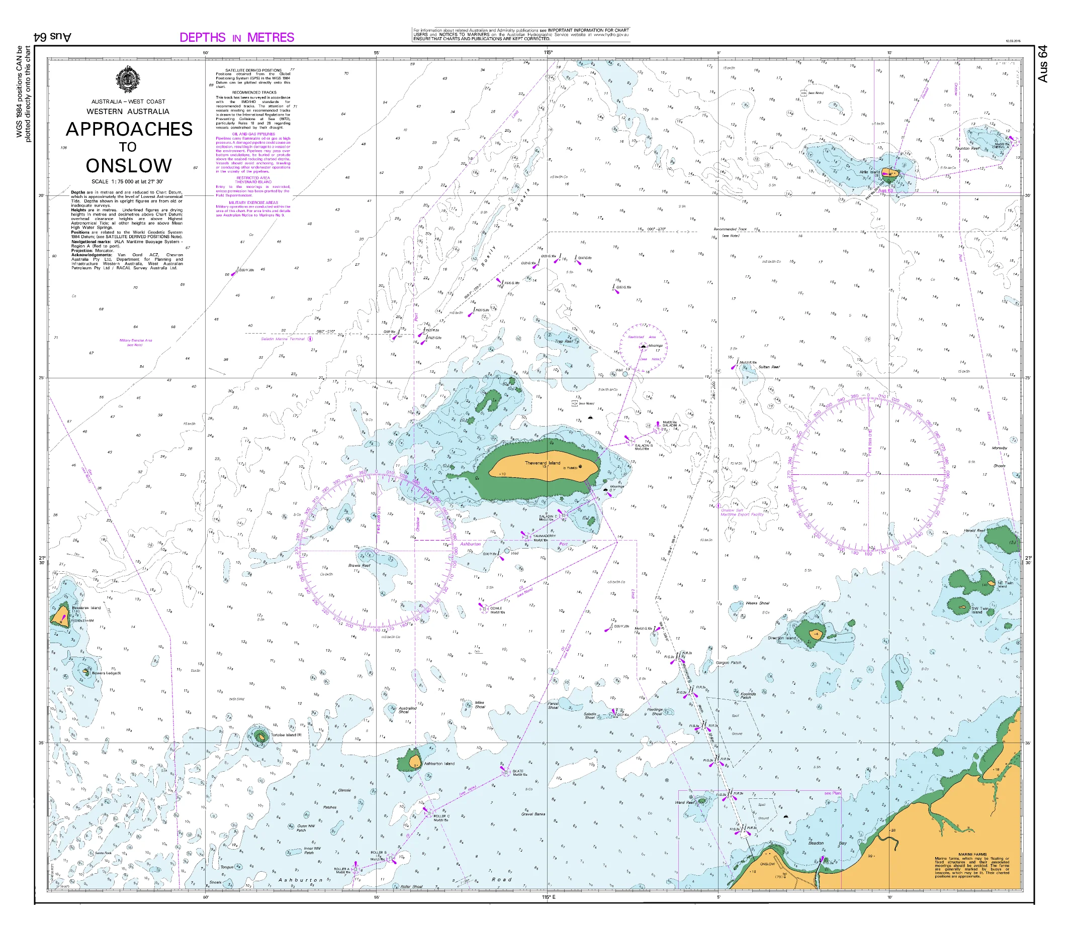
AUS 64 — Approaches to Onslow, WA Nautical Chart
For skippers, pilots, and coastal crews transiting the Ashburton/Onslow approaches
Make confident landfall into Onslow with AUS 64. Purpose-built approach coverage at 1:75,000 on Mercator projection — ideal for shaping tracks, timing tidal windows, and waypoint checks along the mid–west WA coastline. Includes a large-scale Onslow town/wharf plan for close-quarters pilotage.
Why skippers choose this chart
-
🧭 Built for approach — 1:75,000 main sheet balances coastal awareness with practical pilotage detail.
-
🚢 Traffic & hazards awareness — Helpful for aligning fairways, leads, reefs and banks on the final run-in.
-
🛰️ Mercator + UTM inset — Straight bearings on the main; crisp grid plotting on the Onslow plan.
-
📍 Exact bounds — All four limits listed for quick position checks (see below).
-
🗺️ Deck-ready materials — Soft-matte writeable laminate front for correction/grease pencils.
-
🇦🇺 Printed in Australia — Colour-managed, hand-checked.
Coverage
-
Main Chart — AUS 64: Australia West Coast · Western Australia · Approaches to Onslow
-
Scale: 1:75,000 · Projection: Mercator
-
Bounds: N 21°16.29′ S · S 21°39.00′ S · E 115°13.83′ E · W 114°45.44′ E
-
Publication: 22-Feb-2002 · Latest Edition: 16-Apr-2026
-
Premium materials & finishes
-
Paper (120 gsm matte) — Crisp, flexible and chart-table friendly; ideal under nav-station glass.
-
Laminated (soft-matte front / gloss back, edge-sealed) — Front is low-glare and writeable with chart-correction/grease pencils; gloss back adds rigidity. Wipes clean with a soft cloth.
Note: We use a soft-matte writeable face with a gloss reverse so you can annotate fixes, bearings and ETAs directly on the chart, then clean down between passages.
On-board & ashore use
-
🧭 Pilotage & approach planning — Plot channels, clearing bearings, and contingencies into Onslow.
-
📒 Crew briefings — Clear layout for leads/marks and waypoint verification.
-
🛠️ Bridge/club display — Durable laminated option for noticeboards and training rooms.
-
🎁 Gift for skippers — A practical Pilbara approach chart for WA crews.
Specifications
| Field | Detail |
|---|---|
| Chart Number | AUS 64 |
| Title | Australia West Coast — Western Australia — Approaches to Onslow |
| Geographic Location | Australia |
| Scale (main) | 1:75,000 |
| Projection | Mercator (main); Universal Transverse Mercator (subchart) |
| North / South Limits | 21°16.29′ S / 21°39.00′ S |
| East / West Limits | 115°13.83′ E / 114°45.44′ E |
| Publication Date | 22-Feb-2002 |
| Latest Edition | 16-Apr-2026 |
| Sheet Size | 1100 mm (W) × 770 mm (H) |
| Available Finishes | Paper (120 gsm matte); Laminated (soft-matte writeable front, gloss back, edge-sealed) |
| Inks | Pigment-based, fade-resistant |
| Origin | Printed in Australia |
Important note (mariner’s guidance)
This product is ideal for planning, briefing, education, and display. For underway navigation, always carry and consult the latest official hydrographic chart or approved ECDIS and current Notices to Mariners. Local conditions and aids may change.
Ready to make your Onslow approach?
Select your finish above and add to cart. We’ll print locally, hand-check, and ship with care.