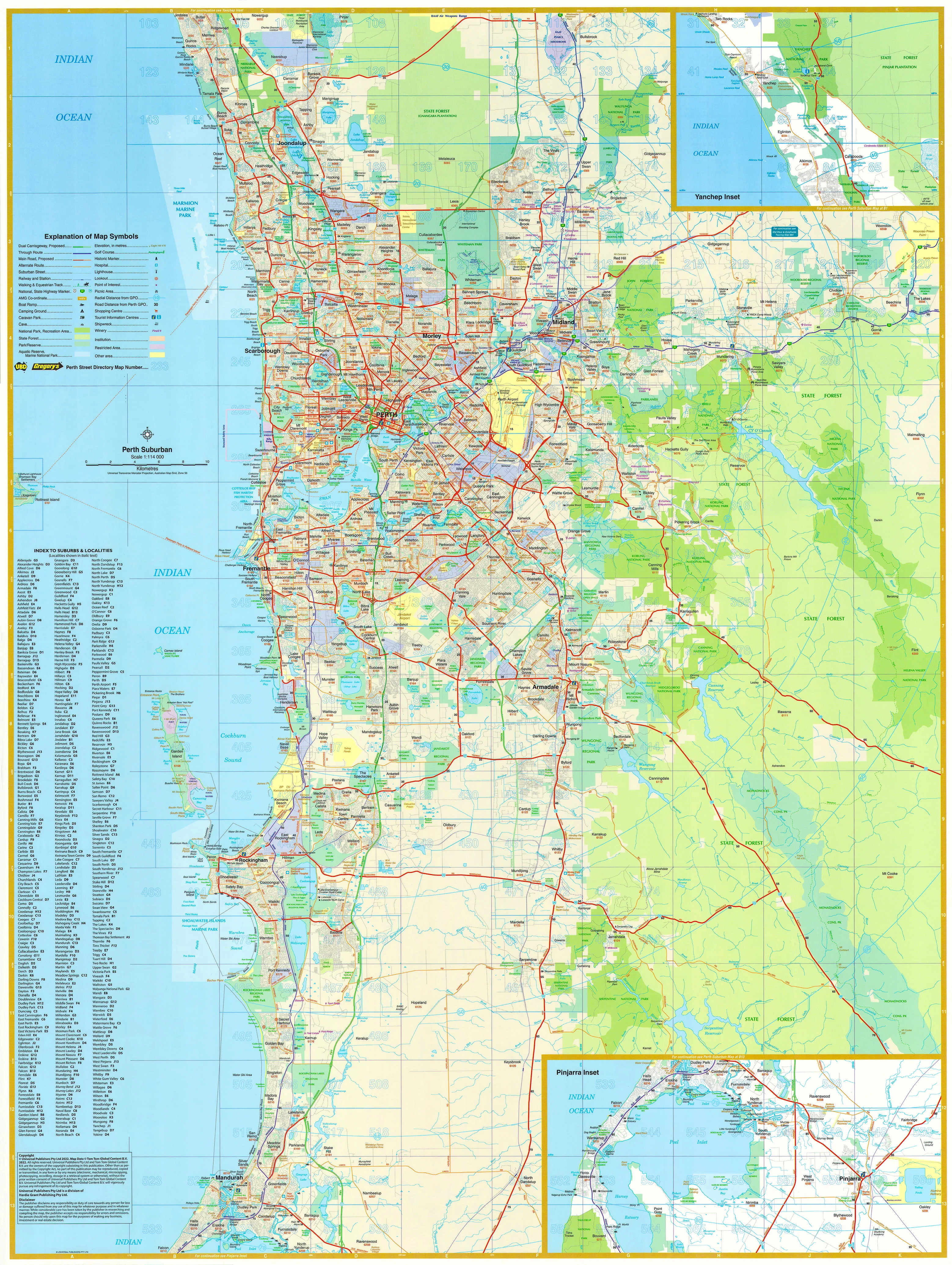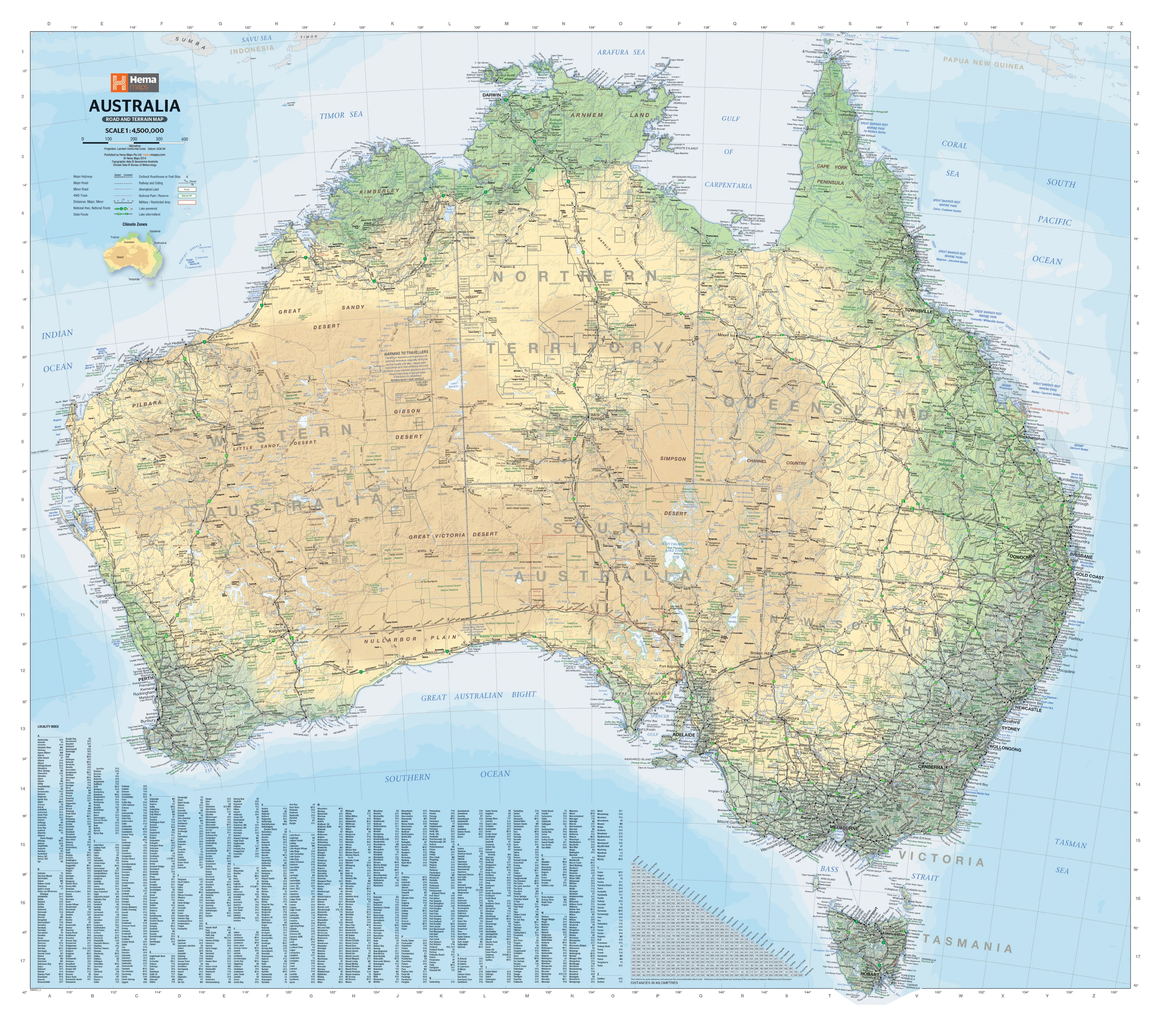
Australia Land & Seabed Relief Wall Map
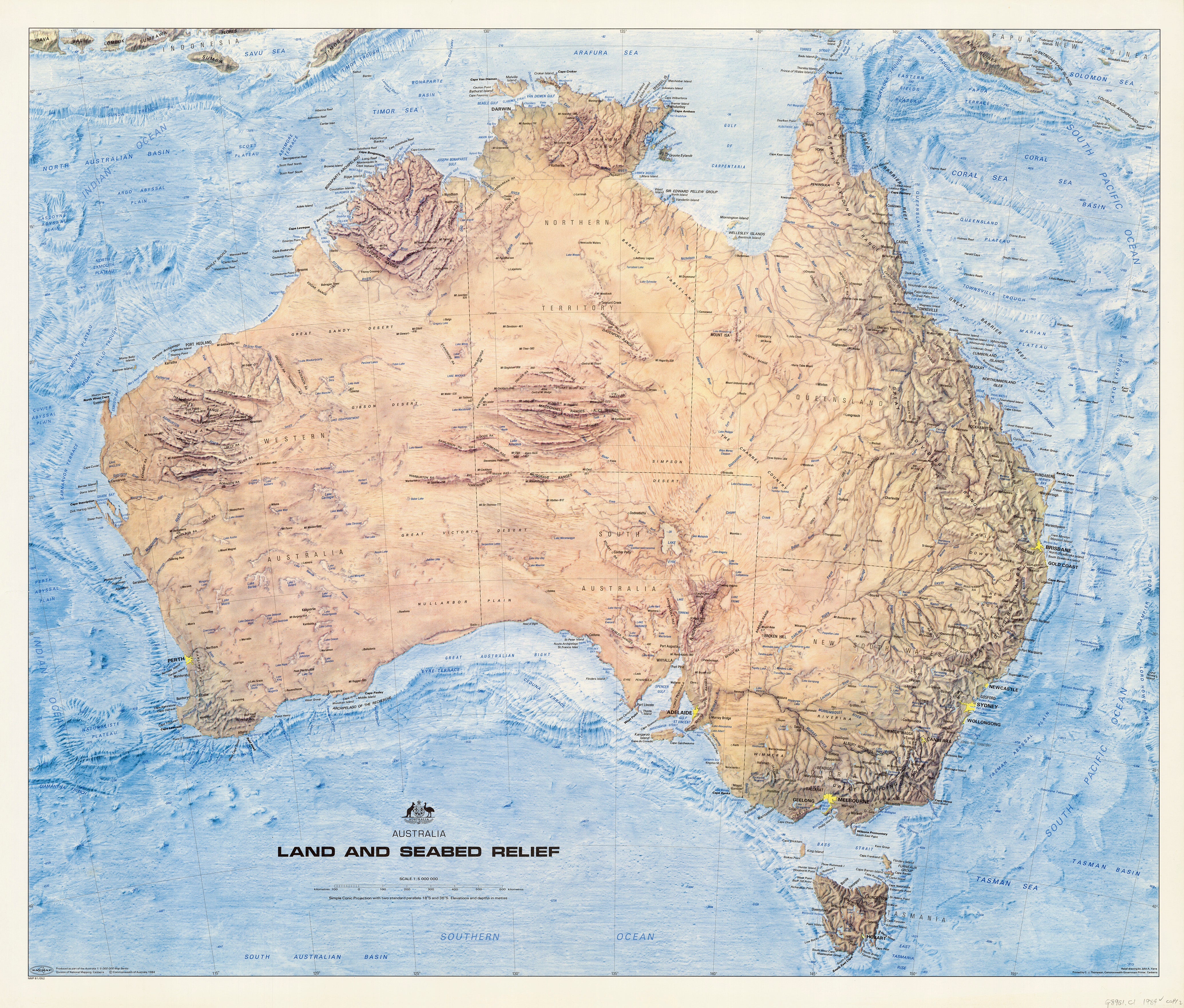
Australia Land & Seabed Relief Wall Map — John A. Yarra (1984) — 1000 × 800 mm
Topographic + Bathymetric • 1:5,000,000 • Premium Finishes
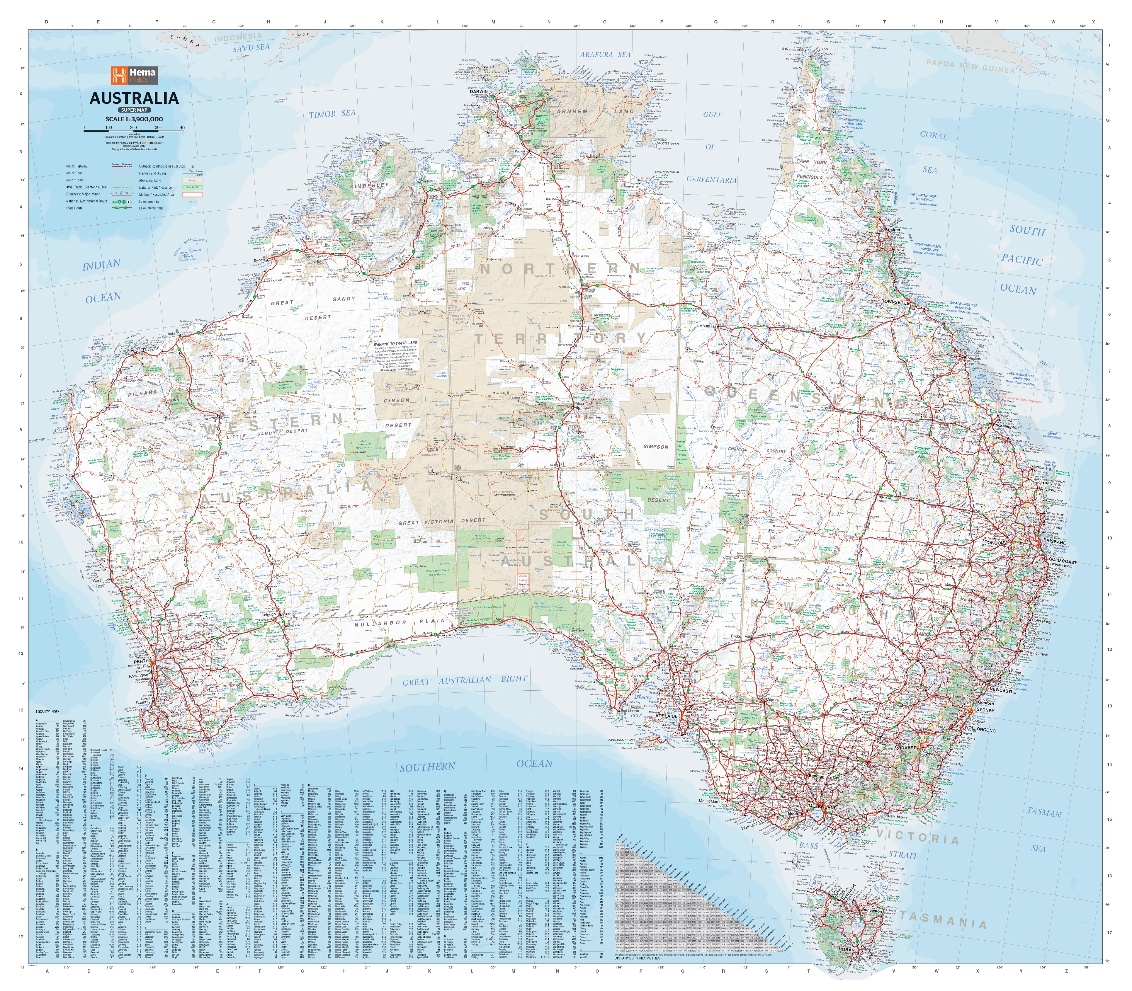
A landmark plate from the Division of National Mapping’s Australia 1:5,000,000 series, this 1984 John A. Yarra map reveals the continent above and below the waterline—ranges and basins on land, shelves, slopes, ridges, and trenches at sea—with refined shaded relief and bathymetric detail. It’s both a conversation piece and a serious reference for classrooms, studios, and ocean-curious minds.
🗺️ Map Features (Expanded)
-
Dual-World View (Land + Seafloor): Integrated hypsometric land shading with bathymetric depth contours and soundings—see how the Great Dividing Range transitions to the continental shelf, then drops along the continental slope to abyssal plains.
-
Geomorphology at a Glance: Read the story of plate margins, submarine plateaus, seamount chains, and mid-ocean ridges that frame Australia’s maritime domain.
-
Clear, Wall-Readable Labelling: Precisely tuned type and symbology for viewing across rooms—ideal for boardrooms, lecture theatres, and studio walls.
-
Cartographic Integrity: Drawn to 1:5,000,000 on a simple conic projection (standard parallels 18°S & 36°S) with coverage 110°E–160°E and 10°S–45°S.
-
Context for Curious Minds: Spot heights, landform notation, and seabed morphology help decode why weather, currents, biodiversity and resources vary around the coast.
-
Archival Heritage (1984): A faithful reproduction of a classic—revered by geographers, educators and collectors.
🎓 Who This Map Serves
-
Educators & Students: Visualise orogeny, erosion, and ocean-floor spreading in one compact teaching tool.
-
Marine & Environmental Pros: Quick situational awareness—shelf width, basin geometry, and ridge orientation at a glance.
-
Design & Interiors: A sophisticated focal piece for studies, living rooms, and studios; pairs beautifully with timber frames or hang rails.
-
Collectors of Aussie Cartography: A must-have historical plate that bridges terrestrial and marine science.
✨ Available Finishes
| Format | Description |
|---|---|
| 📜 Paper (160 gsm matte) | Heavyweight, smooth matte—perfect for framing under glass. |
| 🧼 Laminated (Encapsulated) | True encapsulation in 2 × 80-micron gloss; durable, wipe-clean, tear-resistant. |
| 🪵 Laminated + Timber Hang Rails | Laminated print mounted with natural lacquered timber rails (top & bottom) and a hanging cord—ready to display. |
| 🖼️ Canvas (395 gsm HP Professional Matte) | Textured, gallery-grade canvas printed with pigment-based, fade-resistant inks. |
| 🪵 Canvas + Timber Hang Rails | Canvas mounted with lacquered timber rails and cord—no framing required for a timeless look. |
Note: Hang-railed maps are professionally mounted—please allow up to 10 working days.
📐 Specifications
| Feature | Detail |
|---|---|
| Title | Land & Seabed Relief: Australia |
| Cartographer | John A. Yarra |
| Series/Publisher | Division of National Mapping — Australia 1:5,000,000 series |
| Year | 1984 |
| Scale | 1:5,000,000 |
| Projection | Simple conic (standard parallels 18°S & 36°S) |
| Extent | 110°E–160°E, 10°S–45°S |
| Size | 1000 mm (W) × 850 mm (H) |
| Material Options | Paper (160 gsm); Laminated (2 × 80-micron gloss encapsulation); Laminated + Timber Rails; Canvas (395 gsm HP Professional Matte); Canvas + Timber Rails |
| Printing | Archival, pigment-based, fade-resistant inks |
| Origin | Printed in Australia |
🧩 How to Use It
-
Teach & Present: Use as a front-of-room anchor for units on tectonics, coastal processes, and Australian biomes.
-
Plan & Explore: Overlay tracing paper or use non-permanent markers (laminated version) for lesson notes or project mark-ups.
-
Decor & Display: Choose canvas with timber rails for a warm, gallery feel—or paper under glass for crisp, contemporary framing.
🧼 Care & Handling
-
Paper: Handle with clean, dry hands; frame under glass or acrylic for longevity.
-
Laminated: Wipe gently with a soft, damp cloth; use non-permanent markers only.
-
Canvas: Dust lightly with a soft brush or microfiber cloth; avoid direct, prolonged sunlight.
🤝 Our Commitment
-
Local craftsmanship: Designed, printed, and finished in Australia.
-
Premium materials: Archival HP pigment inks, professional laminates, natural timber rails.
-
Colour-managed clarity: Wall-readable labelling and consistent cartography at mega scale.
-
Built to last: Durable finishes to extend service life and reduce waste.
-
Packed with care: Every map is hand-checked and shipped to arrive clean and display-ready.
🚚 Delivery
-
Paper, Laminated & Canvas (rolled): Dispatched within 1–2 business days.
-
Hang-Railed (laminated or canvas): Made to order—allow up to 10 working days.
-
Protective Packaging: Robust tubes and corner protection keep your map pristine.
Bring Australia’s surface and seafloor into crisp, compelling focus—add to cart and elevate your wall with a classic of Australian cartography.
Original: $57.20
-65%$57.20
$20.02Product Information
Product Information
Shipping & Returns
Shipping & Returns
Description
Australia Land & Seabed Relief Wall Map — John A. Yarra (1984) — 1000 × 800 mm
Topographic + Bathymetric • 1:5,000,000 • Premium Finishes
A landmark plate from the Division of National Mapping’s Australia 1:5,000,000 series, this 1984 John A. Yarra map reveals the continent above and below the waterline—ranges and basins on land, shelves, slopes, ridges, and trenches at sea—with refined shaded relief and bathymetric detail. It’s both a conversation piece and a serious reference for classrooms, studios, and ocean-curious minds.
🗺️ Map Features (Expanded)
-
Dual-World View (Land + Seafloor): Integrated hypsometric land shading with bathymetric depth contours and soundings—see how the Great Dividing Range transitions to the continental shelf, then drops along the continental slope to abyssal plains.
-
Geomorphology at a Glance: Read the story of plate margins, submarine plateaus, seamount chains, and mid-ocean ridges that frame Australia’s maritime domain.
-
Clear, Wall-Readable Labelling: Precisely tuned type and symbology for viewing across rooms—ideal for boardrooms, lecture theatres, and studio walls.
-
Cartographic Integrity: Drawn to 1:5,000,000 on a simple conic projection (standard parallels 18°S & 36°S) with coverage 110°E–160°E and 10°S–45°S.
-
Context for Curious Minds: Spot heights, landform notation, and seabed morphology help decode why weather, currents, biodiversity and resources vary around the coast.
-
Archival Heritage (1984): A faithful reproduction of a classic—revered by geographers, educators and collectors.
🎓 Who This Map Serves
-
Educators & Students: Visualise orogeny, erosion, and ocean-floor spreading in one compact teaching tool.
-
Marine & Environmental Pros: Quick situational awareness—shelf width, basin geometry, and ridge orientation at a glance.
-
Design & Interiors: A sophisticated focal piece for studies, living rooms, and studios; pairs beautifully with timber frames or hang rails.
-
Collectors of Aussie Cartography: A must-have historical plate that bridges terrestrial and marine science.
✨ Available Finishes
| Format | Description |
|---|---|
| 📜 Paper (160 gsm matte) | Heavyweight, smooth matte—perfect for framing under glass. |
| 🧼 Laminated (Encapsulated) | True encapsulation in 2 × 80-micron gloss; durable, wipe-clean, tear-resistant. |
| 🪵 Laminated + Timber Hang Rails | Laminated print mounted with natural lacquered timber rails (top & bottom) and a hanging cord—ready to display. |
| 🖼️ Canvas (395 gsm HP Professional Matte) | Textured, gallery-grade canvas printed with pigment-based, fade-resistant inks. |
| 🪵 Canvas + Timber Hang Rails | Canvas mounted with lacquered timber rails and cord—no framing required for a timeless look. |
Note: Hang-railed maps are professionally mounted—please allow up to 10 working days.
📐 Specifications
| Feature | Detail |
|---|---|
| Title | Land & Seabed Relief: Australia |
| Cartographer | John A. Yarra |
| Series/Publisher | Division of National Mapping — Australia 1:5,000,000 series |
| Year | 1984 |
| Scale | 1:5,000,000 |
| Projection | Simple conic (standard parallels 18°S & 36°S) |
| Extent | 110°E–160°E, 10°S–45°S |
| Size | 1000 mm (W) × 850 mm (H) |
| Material Options | Paper (160 gsm); Laminated (2 × 80-micron gloss encapsulation); Laminated + Timber Rails; Canvas (395 gsm HP Professional Matte); Canvas + Timber Rails |
| Printing | Archival, pigment-based, fade-resistant inks |
| Origin | Printed in Australia |
🧩 How to Use It
-
Teach & Present: Use as a front-of-room anchor for units on tectonics, coastal processes, and Australian biomes.
-
Plan & Explore: Overlay tracing paper or use non-permanent markers (laminated version) for lesson notes or project mark-ups.
-
Decor & Display: Choose canvas with timber rails for a warm, gallery feel—or paper under glass for crisp, contemporary framing.
🧼 Care & Handling
-
Paper: Handle with clean, dry hands; frame under glass or acrylic for longevity.
-
Laminated: Wipe gently with a soft, damp cloth; use non-permanent markers only.
-
Canvas: Dust lightly with a soft brush or microfiber cloth; avoid direct, prolonged sunlight.
🤝 Our Commitment
-
Local craftsmanship: Designed, printed, and finished in Australia.
-
Premium materials: Archival HP pigment inks, professional laminates, natural timber rails.
-
Colour-managed clarity: Wall-readable labelling and consistent cartography at mega scale.
-
Built to last: Durable finishes to extend service life and reduce waste.
-
Packed with care: Every map is hand-checked and shipped to arrive clean and display-ready.
🚚 Delivery
-
Paper, Laminated & Canvas (rolled): Dispatched within 1–2 business days.
-
Hang-Railed (laminated or canvas): Made to order—allow up to 10 working days.
-
Protective Packaging: Robust tubes and corner protection keep your map pristine.
Bring Australia’s surface and seafloor into crisp, compelling focus—add to cart and elevate your wall with a classic of Australian cartography.