Chile National Geographic Folded Map
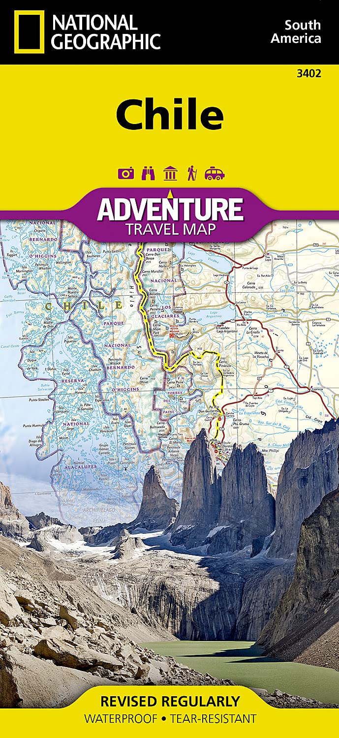
🇨🇱 Chile National Geographic Adventure Travel Map
Waterproof • Tear-Resistant • Detailed Road & Adventure Map
Scale: 1:1,950,000 | Size: 965 mm x 660 mm (folded: 235 mm x 108 mm)
🧭 Your Ultimate Companion for Exploring Chile
From the lunar landscapes of the Atacama Desert to the windswept fjords of Patagonia, Chile is a land of dramatic contrasts and unforgettable journeys. Whether you're planning a road trip, trekking expedition, or cultural deep dive, this National Geographic Adventure Map provides the perfect blend of practical detail and geographic insight.
Crafted for durability and legibility, the map is printed on synthetic waterproof, tear-resistant paper, making it tough enough to handle any terrain or weather you may encounter on your travels.
🗺️ Coverage & Map Features
This double-sided map offers complete coverage of Chile from Peru to Cape Horn, highlighting key travel destinations, road networks, and natural landmarks:
Side One: Northern Chile
-
From Arica and the Peruvian border south to Concepción
-
Includes:
-
Santiago, La Serena, Antofagasta, Calama, Chanaral
-
The Atacama Desert and Andean altiplano
-
-
Inset Maps:
-
🏝️ Easter Island (Rapa Nui)
-
🏝️ Juan Fernández Archipelago
-
🏝️ San Félix & San Ambrosio Islands
-
Side Two: Southern Chile
-
Overlapping north section, extends all the way to Cape Horn
-
Covers:
-
Puerto Montt, Coyhaique, Punta Arenas, and Tierra del Fuego
-
Iconic destinations like Torres del Paine, Carretera Austral, and numerous national parks
-
📌 Map Highlights
-
🛣️ Clearly marked highways and secondary roads with distances
-
🚶 Tracks and trails for trekking, biking, and remote exploration
-
📍 Hundreds of points of interest: parks, reserves, archaeological sites, UNESCO locations
-
🏙️ Cities and towns with a full index for easy navigation
-
🌄 National parks, glaciers, lakes, and volcanoes clearly displayed
-
🧭 Includes latitude/longitude grids, scale bars, and a compass rose for GPS navigation
💡 Why Choose This Map?
-
✅ Adventure-Ready: Durable and packable—built for outdoor use
-
✅ Comprehensive: Covers remote regions most maps omit
-
✅ Authoritative: Trusted National Geographic cartography
-
✅ Perfect for All Travellers: Road trippers, hikers, cyclists, and expedition planners
📐 Specifications
| Feature | Detail |
|---|---|
| Scale | 1:1,950,000 |
| Sheet Size (Unfolded) | 965 mm x 660 mm (38” x 26”) |
| Folded Size | 235 mm x 108 mm (9.25” x 4.25”) |
| Format | Folded, double-sided map |
| Material | Waterproof & tear-resistant synthetic paper |
| Publisher | National Geographic Maps |
🧳 The Perfect Map for Every Chilean Adventure
Whether you're:
-
Driving the Pan-American Highway
-
Trekking the Torres del Paine Circuit
-
Stargazing in the Atacama
-
Or navigating the islands of Patagonia
This is the essential tool for seeing Chile beyond the guidebooks.
📦 Ships folded. Lightweight, packable, and ideal for on-the-go adventurers.
Original: $20.00
-65%$20.00
$7.00Product Information
Product Information
Shipping & Returns
Shipping & Returns
Description
🇨🇱 Chile National Geographic Adventure Travel Map
Waterproof • Tear-Resistant • Detailed Road & Adventure Map
Scale: 1:1,950,000 | Size: 965 mm x 660 mm (folded: 235 mm x 108 mm)
🧭 Your Ultimate Companion for Exploring Chile
From the lunar landscapes of the Atacama Desert to the windswept fjords of Patagonia, Chile is a land of dramatic contrasts and unforgettable journeys. Whether you're planning a road trip, trekking expedition, or cultural deep dive, this National Geographic Adventure Map provides the perfect blend of practical detail and geographic insight.
Crafted for durability and legibility, the map is printed on synthetic waterproof, tear-resistant paper, making it tough enough to handle any terrain or weather you may encounter on your travels.
🗺️ Coverage & Map Features
This double-sided map offers complete coverage of Chile from Peru to Cape Horn, highlighting key travel destinations, road networks, and natural landmarks:
Side One: Northern Chile
-
From Arica and the Peruvian border south to Concepción
-
Includes:
-
Santiago, La Serena, Antofagasta, Calama, Chanaral
-
The Atacama Desert and Andean altiplano
-
-
Inset Maps:
-
🏝️ Easter Island (Rapa Nui)
-
🏝️ Juan Fernández Archipelago
-
🏝️ San Félix & San Ambrosio Islands
-
Side Two: Southern Chile
-
Overlapping north section, extends all the way to Cape Horn
-
Covers:
-
Puerto Montt, Coyhaique, Punta Arenas, and Tierra del Fuego
-
Iconic destinations like Torres del Paine, Carretera Austral, and numerous national parks
-
📌 Map Highlights
-
🛣️ Clearly marked highways and secondary roads with distances
-
🚶 Tracks and trails for trekking, biking, and remote exploration
-
📍 Hundreds of points of interest: parks, reserves, archaeological sites, UNESCO locations
-
🏙️ Cities and towns with a full index for easy navigation
-
🌄 National parks, glaciers, lakes, and volcanoes clearly displayed
-
🧭 Includes latitude/longitude grids, scale bars, and a compass rose for GPS navigation
💡 Why Choose This Map?
-
✅ Adventure-Ready: Durable and packable—built for outdoor use
-
✅ Comprehensive: Covers remote regions most maps omit
-
✅ Authoritative: Trusted National Geographic cartography
-
✅ Perfect for All Travellers: Road trippers, hikers, cyclists, and expedition planners
📐 Specifications
| Feature | Detail |
|---|---|
| Scale | 1:1,950,000 |
| Sheet Size (Unfolded) | 965 mm x 660 mm (38” x 26”) |
| Folded Size | 235 mm x 108 mm (9.25” x 4.25”) |
| Format | Folded, double-sided map |
| Material | Waterproof & tear-resistant synthetic paper |
| Publisher | National Geographic Maps |
🧳 The Perfect Map for Every Chilean Adventure
Whether you're:
-
Driving the Pan-American Highway
-
Trekking the Torres del Paine Circuit
-
Stargazing in the Atacama
-
Or navigating the islands of Patagonia
This is the essential tool for seeing Chile beyond the guidebooks.
📦 Ships folded. Lightweight, packable, and ideal for on-the-go adventurers.