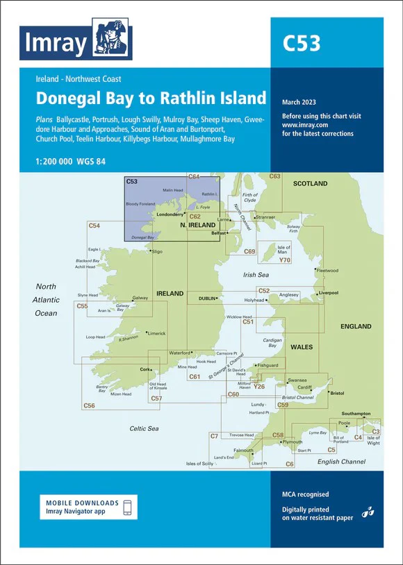
Donegal Bay to Rathlin Island Imray Chart
Donegal Bay to Rathlin Island imray 1:2000 000
The north-west coast of Ireland from Donegal Bay to Rathlin Head. One-minute gridlines. Larger scale plans of the Sound of Aran and Burtonport, Gweedore Harbour and approaches, Mullaghmore Bay, Lough Swilly, Teelin Harbour, Sheep Haven, Killybegs harbour, Mulroy harbour and Portrush. Detailed plans or insets include: Ballycastle (1:5000) Portrush (1:15 000) Lough Swilly (1:45 000) Mulroy Bay (1:30 000) Sheep Haven (1:30 000) Gweedore Harbour and Approaches (1:40 000) Sound of Aran and Burtonport (1:30 000) Church Pool (1:20 000) Teelin Harbour (1:10 000) Killybegs Harbour (1:12 500) Mullaghmore Bay (1:50 000)
Imray C Series charts cover sailing areas in northwestern Europe. These series form the most comprehensive range of yachtsmen’s charts available. Suitable for passage planning and larger scale charts for navigating the coastal waters even close to shore.
The information shown on charts is liable to constant change. Corrections are made available on the Imray website: https://store.imray.com/collections/imray-charts-1 Visit the website to obtain the latest correction notices which are available as free downloads and are continually updated. Imray is now adding smart phone readable QR codes on their charts.
These will provide a fast link to chart corrections and book supplements which are available at the Imray website.
THIS CHART IS ORDER ON-DEMAND PLEASE ALLOW 10 WORKING DAYS FOR DELIVERY
Original: $53.66
-65%$53.66
$18.78Product Information
Product Information
Shipping & Returns
Shipping & Returns
Description
Donegal Bay to Rathlin Island imray 1:2000 000
The north-west coast of Ireland from Donegal Bay to Rathlin Head. One-minute gridlines. Larger scale plans of the Sound of Aran and Burtonport, Gweedore Harbour and approaches, Mullaghmore Bay, Lough Swilly, Teelin Harbour, Sheep Haven, Killybegs harbour, Mulroy harbour and Portrush. Detailed plans or insets include: Ballycastle (1:5000) Portrush (1:15 000) Lough Swilly (1:45 000) Mulroy Bay (1:30 000) Sheep Haven (1:30 000) Gweedore Harbour and Approaches (1:40 000) Sound of Aran and Burtonport (1:30 000) Church Pool (1:20 000) Teelin Harbour (1:10 000) Killybegs Harbour (1:12 500) Mullaghmore Bay (1:50 000)
Imray C Series charts cover sailing areas in northwestern Europe. These series form the most comprehensive range of yachtsmen’s charts available. Suitable for passage planning and larger scale charts for navigating the coastal waters even close to shore.
The information shown on charts is liable to constant change. Corrections are made available on the Imray website: https://store.imray.com/collections/imray-charts-1 Visit the website to obtain the latest correction notices which are available as free downloads and are continually updated. Imray is now adding smart phone readable QR codes on their charts.
These will provide a fast link to chart corrections and book supplements which are available at the Imray website.
THIS CHART IS ORDER ON-DEMAND PLEASE ALLOW 10 WORKING DAYS FOR DELIVERY