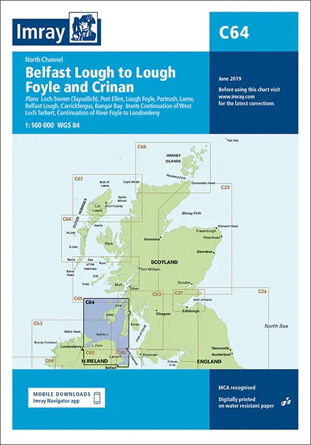
North Channel Imray Chart
North Channel imray 1:160 000
The north-east coast of Ireland from Lough Foyle to Larne, and the Scottish coast from the Mull of Kintyre north to Crinan and Colonsay. One-minute gridlines. Larger scale plans of Loch Sween (Tayvallich), Port Ellen (Islay), West Loch Tarbert, West Loch Tarbert lower part, River Foyle to Londonderry, Lough Foyle, Portrush, Belfast Lough and Larne. Detailed plans or insets include: Loch Sween (Tayvallich) (1:25 000) Continuation of West Loch Tarbert (1:65 000) Port Ellen (1:25 000) Lough Foyle (1:90 000) Portrush (1:20 000) Larne (1:18 500) Belfast Lough (1:110 000) Carrickfergus (1:15 000) Bangor Bay (1:17 500) Continuation of River Foyle to Londonderry (1:60 000) Insets:
Imray C Series charts cover sailing areas in northwestern Europe. These series form the most comprehensive range of yachtsmen’s charts available. Suitable for passage planning and larger scale charts for navigating the coastal waters even close to shore.
The information shown on charts is liable to constant change. Corrections are made available on the Imray website: https://store.imray.com/collections/imray-charts-1 Visit the website to obtain the latest correction notices which are available as free downloads and are continually updated. Imray is now adding smart phone readable QR codes on their charts.
These will provide a fast link to chart corrections and book supplements which are available at the Imray website.
THIS CHART IS ORDER ON-DEMAND PLEASE ALLOW 10 WORKING DAYS FOR DELIVERY
Original: $53.66
-65%$53.66
$18.78Product Information
Product Information
Shipping & Returns
Shipping & Returns
Description
North Channel imray 1:160 000
The north-east coast of Ireland from Lough Foyle to Larne, and the Scottish coast from the Mull of Kintyre north to Crinan and Colonsay. One-minute gridlines. Larger scale plans of Loch Sween (Tayvallich), Port Ellen (Islay), West Loch Tarbert, West Loch Tarbert lower part, River Foyle to Londonderry, Lough Foyle, Portrush, Belfast Lough and Larne. Detailed plans or insets include: Loch Sween (Tayvallich) (1:25 000) Continuation of West Loch Tarbert (1:65 000) Port Ellen (1:25 000) Lough Foyle (1:90 000) Portrush (1:20 000) Larne (1:18 500) Belfast Lough (1:110 000) Carrickfergus (1:15 000) Bangor Bay (1:17 500) Continuation of River Foyle to Londonderry (1:60 000) Insets:
Imray C Series charts cover sailing areas in northwestern Europe. These series form the most comprehensive range of yachtsmen’s charts available. Suitable for passage planning and larger scale charts for navigating the coastal waters even close to shore.
The information shown on charts is liable to constant change. Corrections are made available on the Imray website: https://store.imray.com/collections/imray-charts-1 Visit the website to obtain the latest correction notices which are available as free downloads and are continually updated. Imray is now adding smart phone readable QR codes on their charts.
These will provide a fast link to chart corrections and book supplements which are available at the Imray website.
THIS CHART IS ORDER ON-DEMAND PLEASE ALLOW 10 WORKING DAYS FOR DELIVERY