Papua New Guinea (PNG) Hema Map Laminated
3rd Edition | Durable Laminated Finish | Fully Indexed
Scale: 1:2,167,000
Size: 980 mm x 680 mm
🌍 Navigate Papua New Guinea with Clarity & Confidence
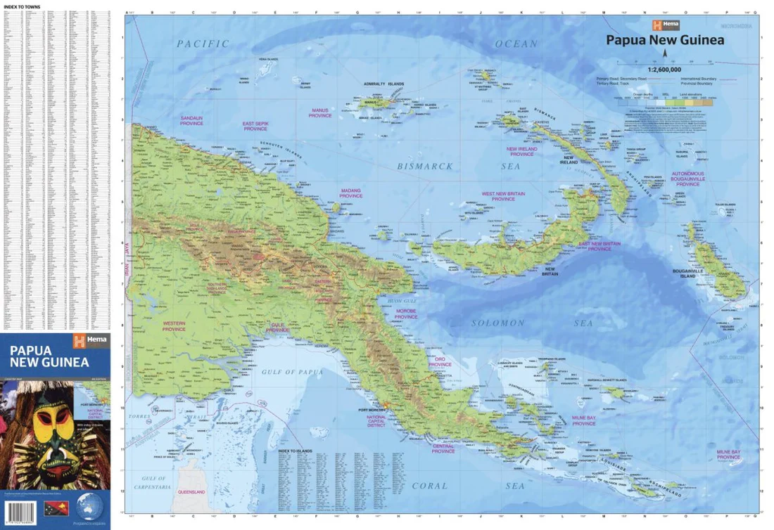
This laminated map of Papua New Guinea from Hema Maps provides an up-to-date and highly detailed overview of one of the world's most remote and geographically complex regions. Printed at a generous scale of 1:2,167,000, this map is ideal for travellers, educators, researchers, and planners who require both accuracy and durability.
Encapsulated in high-quality 80-micron laminate, the map is waterproof, tear-resistant, and wipe-clean—perfect for frequent handling in the field, classroom, or office.
🧭 Key Features
| ✅ | Description |
|---|---|
| 📍 Full PNG Coverage | Covers only Papua New Guinea, including mainland areas and surrounding islands. |
| 🚗 Major & Minor Roads | Clearly marked road network for navigation and logistics. |
| 🏛️ Provincial Boundaries | Easy-to-read regional divisions for political and planning use. |
| 📚 Comprehensive Index | Includes an index of towns, cities, islands, and features. |
| 💧 Laminated for Durability | Flat-laminated for protection against moisture, wear and tear, and marker use. |
📌 Lamination Details
To create the laminated version, the folded map has been carefully opened out and flattened before being fully encapsulated in 80-micron gloss laminate. This preserves the map’s surface while allowing for:
-
Use with whiteboard markers
-
Application of removable map dots
-
Easy cleaning and long-term use
🔔 Note: As the original map was folded, faint fold lines will remain visible beneath the lamination.
📏 Map Specifications
| Attribute | Detail |
|---|---|
| Publisher | Hema Maps (Australia) |
| Title | Papua New Guinea (PNG) Laminated Map |
| Edition | 3rd Edition |
| Scale | 1:2,167,000 |
| Size | 980 mm (w) x 680 mm (h) |
| Format | Laminated (flat, folded lines visible) |
| Index Included | Yes – towns, cities, islands |
🌐 Who Is This Map For?
-
🧭 Adventure travellers exploring PNG’s wild coasts, Highlands, or island chains
-
📊 Development professionals and researchers needing accurate administrative and road data
-
🏡 Educators and students studying Pacific geopolitics or human geography
-
🖼️ Home, office, or classroom display where durable reference material is essential
Original: $42.89
-65%$42.89
$15.01Product Information
Product Information
Shipping & Returns
Shipping & Returns
Description
3rd Edition | Durable Laminated Finish | Fully Indexed
Scale: 1:2,167,000
Size: 980 mm x 680 mm
🌍 Navigate Papua New Guinea with Clarity & Confidence
This laminated map of Papua New Guinea from Hema Maps provides an up-to-date and highly detailed overview of one of the world's most remote and geographically complex regions. Printed at a generous scale of 1:2,167,000, this map is ideal for travellers, educators, researchers, and planners who require both accuracy and durability.
Encapsulated in high-quality 80-micron laminate, the map is waterproof, tear-resistant, and wipe-clean—perfect for frequent handling in the field, classroom, or office.
🧭 Key Features
| ✅ | Description |
|---|---|
| 📍 Full PNG Coverage | Covers only Papua New Guinea, including mainland areas and surrounding islands. |
| 🚗 Major & Minor Roads | Clearly marked road network for navigation and logistics. |
| 🏛️ Provincial Boundaries | Easy-to-read regional divisions for political and planning use. |
| 📚 Comprehensive Index | Includes an index of towns, cities, islands, and features. |
| 💧 Laminated for Durability | Flat-laminated for protection against moisture, wear and tear, and marker use. |
📌 Lamination Details
To create the laminated version, the folded map has been carefully opened out and flattened before being fully encapsulated in 80-micron gloss laminate. This preserves the map’s surface while allowing for:
-
Use with whiteboard markers
-
Application of removable map dots
-
Easy cleaning and long-term use
🔔 Note: As the original map was folded, faint fold lines will remain visible beneath the lamination.
📏 Map Specifications
| Attribute | Detail |
|---|---|
| Publisher | Hema Maps (Australia) |
| Title | Papua New Guinea (PNG) Laminated Map |
| Edition | 3rd Edition |
| Scale | 1:2,167,000 |
| Size | 980 mm (w) x 680 mm (h) |
| Format | Laminated (flat, folded lines visible) |
| Index Included | Yes – towns, cities, islands |
🌐 Who Is This Map For?
-
🧭 Adventure travellers exploring PNG’s wild coasts, Highlands, or island chains
-
📊 Development professionals and researchers needing accurate administrative and road data
-
🏡 Educators and students studying Pacific geopolitics or human geography
-
🖼️ Home, office, or classroom display where durable reference material is essential