Thames Estuary Imray Chart
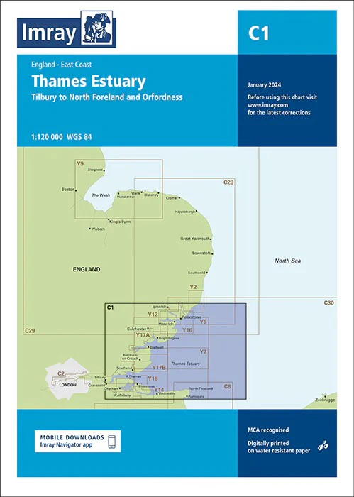
Thames Estuary Imray 1:120,000 The mouth of the River Thames. From Orfordness to Ramsgate in the south. This chart shows the Thames as far as Canvey Island.
This edition has been updated with the latest depth measurements (particularly in the Princess Channel, King's Channel, Fisherman's Gat and Long Sand Head). It also shows the latest wind farms and developments. Minor changes have been made to the Sunk TSS. Various improvements have also been made to the map image and the colours used. Imray C Series charts cover sailing areas in northwestern Europe.
These series form the most comprehensive range of yachtsmen’s charts available. Suitable for passage planning and larger scale charts for navigating the coastal waters even close to shore.
The information shown on charts is liable to constant change. Corrections are made available on the Imray website: https://store.imray.com/collections/imray-charts-1 Visit the website to obtain the latest correction notices which are available as free downloads and are continually updated. Imray is now adding smart phone readable QR codes on their charts.
These will provide a fast link to chart corrections and book supplements which are available at the Imray website.
THIS CHART IS ORDER ON-DEMAND PLEASE ALLOW 10 WORKING DAYS FOR DELIVERY
Original: $53.66
-65%$53.66
$18.78Product Information
Product Information
Shipping & Returns
Shipping & Returns
Description
Thames Estuary Imray 1:120,000 The mouth of the River Thames. From Orfordness to Ramsgate in the south. This chart shows the Thames as far as Canvey Island.
This edition has been updated with the latest depth measurements (particularly in the Princess Channel, King's Channel, Fisherman's Gat and Long Sand Head). It also shows the latest wind farms and developments. Minor changes have been made to the Sunk TSS. Various improvements have also been made to the map image and the colours used. Imray C Series charts cover sailing areas in northwestern Europe.
These series form the most comprehensive range of yachtsmen’s charts available. Suitable for passage planning and larger scale charts for navigating the coastal waters even close to shore.
The information shown on charts is liable to constant change. Corrections are made available on the Imray website: https://store.imray.com/collections/imray-charts-1 Visit the website to obtain the latest correction notices which are available as free downloads and are continually updated. Imray is now adding smart phone readable QR codes on their charts.
These will provide a fast link to chart corrections and book supplements which are available at the Imray website.
THIS CHART IS ORDER ON-DEMAND PLEASE ALLOW 10 WORKING DAYS FOR DELIVERY