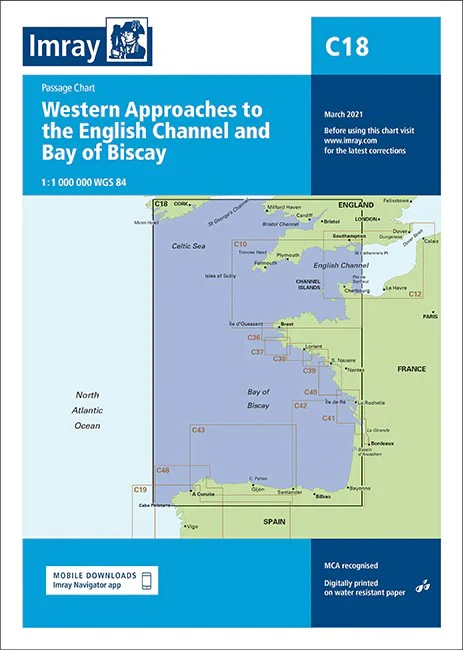
Western Approaches to English Channel & Bay of Biscay Imray Chart
Western Approaches to the English Channel & Bay of Biscay Passage Chart 1:1 000 000
Passage chart of western section of Bay of Biscay, showing Falmouth to Ushant and NW corner of Spain from Gijon to Vigo. Ten-minute gridlines. Scale: 1 : 686.000. Larger scale plans of Approaches to Vigo, and La Coruna.
This chart has been reschemed alongside C10 Western English Channel Passage Chart so that both charts provide seamless coverage of the English Channel at the same scale (1:375,000). Coverage on this chart allows for passage planning in the Eastern English Channel, from Start Point eastwards along the English coast, and from the Channel Islands eastwards along the French coast, to the Dover Strait.
The latest official UKHO Digital is included, combined with additional information sourced from Imray's network to make it ideal for small craft. The chart has been fully revised throughout. Imray C Series charts cover sailing areas in northwestern Europe.
These series form the most comprehensive range of yachtsmen’s charts available. Suitable for passage planning and larger scale charts for navigating the coastal waters even close to shore.
The information shown on charts is liable to constant change. Corrections are made available on the Imray website: https://store.imray.com/collections/imray-charts-1 Visit the website to obtain the latest correction notices which are available as free downloads and are continually updated. Imray is now adding smart phone readable QR codes on their charts.
These will provide a fast link to chart corrections and book supplements which are available at the Imray website.
THIS CHART IS ORDER ON-DEMAND PLEASE ALLOW 10 WORKING DAYS FOR DELIVERY
Original: $53.66
-65%$53.66
$18.78Product Information
Product Information
Shipping & Returns
Shipping & Returns
Description
Western Approaches to the English Channel & Bay of Biscay Passage Chart 1:1 000 000
Passage chart of western section of Bay of Biscay, showing Falmouth to Ushant and NW corner of Spain from Gijon to Vigo. Ten-minute gridlines. Scale: 1 : 686.000. Larger scale plans of Approaches to Vigo, and La Coruna.
This chart has been reschemed alongside C10 Western English Channel Passage Chart so that both charts provide seamless coverage of the English Channel at the same scale (1:375,000). Coverage on this chart allows for passage planning in the Eastern English Channel, from Start Point eastwards along the English coast, and from the Channel Islands eastwards along the French coast, to the Dover Strait.
The latest official UKHO Digital is included, combined with additional information sourced from Imray's network to make it ideal for small craft. The chart has been fully revised throughout. Imray C Series charts cover sailing areas in northwestern Europe.
These series form the most comprehensive range of yachtsmen’s charts available. Suitable for passage planning and larger scale charts for navigating the coastal waters even close to shore.
The information shown on charts is liable to constant change. Corrections are made available on the Imray website: https://store.imray.com/collections/imray-charts-1 Visit the website to obtain the latest correction notices which are available as free downloads and are continually updated. Imray is now adding smart phone readable QR codes on their charts.
These will provide a fast link to chart corrections and book supplements which are available at the Imray website.
THIS CHART IS ORDER ON-DEMAND PLEASE ALLOW 10 WORKING DAYS FOR DELIVERY