Fife Mess to Duncansby Head Imray Chart
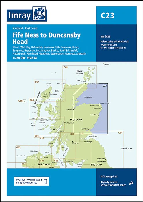
Fife Ness to Duncansby Head imray 1:250 000
The east coast of Scotland from the Firth of Forth to the Moray Firth, also showing the Inverness Firth. Five-minute gridlines.
Larger scale plans of Helmsdale and Fraserburgh. Detailed plans or insets include: Wick Bay Helmsdale Inverness Firth Inverness Nairn Burghead Hopeman Lossiemouth Buckie Banff and Macduff Fraserburgh Peterhead Aberdeen Stonehaven Montrose Arbroath Imray
C Series charts cover sailing areas in northwestern Europe. These series form the most comprehensive range of yachtsmen’s charts available. Suitable for passage planning and larger scale charts for navigating the coastal waters even close to shore.
The information shown on charts is liable to constant change. Corrections are made available on the Imray website: https://store.imray.com/collections/imray-charts-1 Visit the website to obtain the latest correction notices which are available as free downloads and are continually updated. Imray is now adding smart phone readable QR codes on their charts.
These will provide a fast link to chart corrections and book supplements which are available at the Imray website.
THIS CHART IS ORDER ON-DEMAND PLEASE ALLOW 10 WORKING DAYS FOR DELIVERY
Original: $53.66
-65%$53.66
$18.78Product Information
Product Information
Shipping & Returns
Shipping & Returns
Description
Fife Ness to Duncansby Head imray 1:250 000
The east coast of Scotland from the Firth of Forth to the Moray Firth, also showing the Inverness Firth. Five-minute gridlines.
Larger scale plans of Helmsdale and Fraserburgh. Detailed plans or insets include: Wick Bay Helmsdale Inverness Firth Inverness Nairn Burghead Hopeman Lossiemouth Buckie Banff and Macduff Fraserburgh Peterhead Aberdeen Stonehaven Montrose Arbroath Imray
C Series charts cover sailing areas in northwestern Europe. These series form the most comprehensive range of yachtsmen’s charts available. Suitable for passage planning and larger scale charts for navigating the coastal waters even close to shore.
The information shown on charts is liable to constant change. Corrections are made available on the Imray website: https://store.imray.com/collections/imray-charts-1 Visit the website to obtain the latest correction notices which are available as free downloads and are continually updated. Imray is now adding smart phone readable QR codes on their charts.
These will provide a fast link to chart corrections and book supplements which are available at the Imray website.
THIS CHART IS ORDER ON-DEMAND PLEASE ALLOW 10 WORKING DAYS FOR DELIVERY