New South Wales Federal Electoral Divisions and Local Government Areas Map - Riverina & Area
New South Wales Federal Electoral Divisions and Local Government Areas Map - Riverina & Area
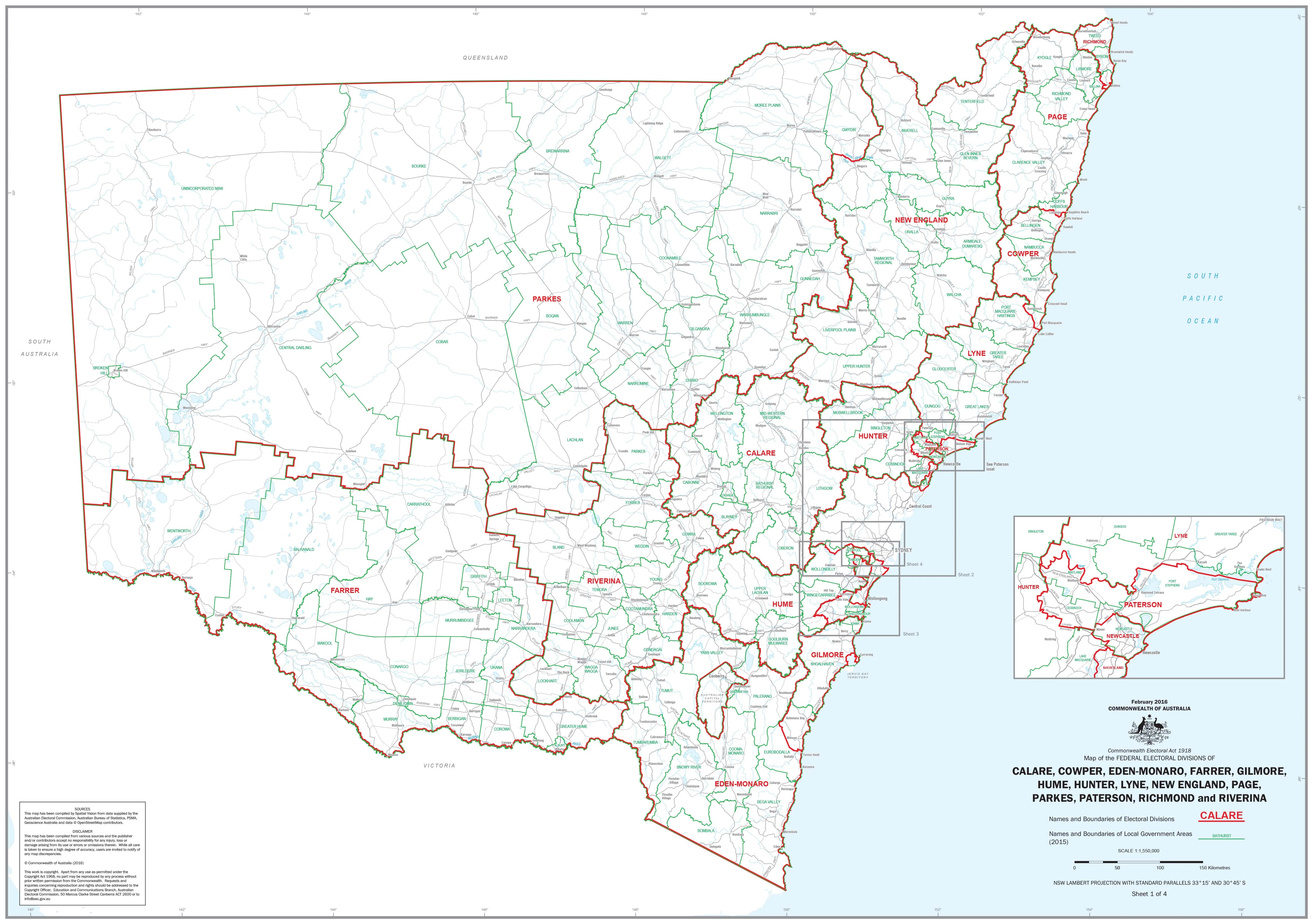
Detailed Political Boundaries Across Eastern and Inland New South Wales
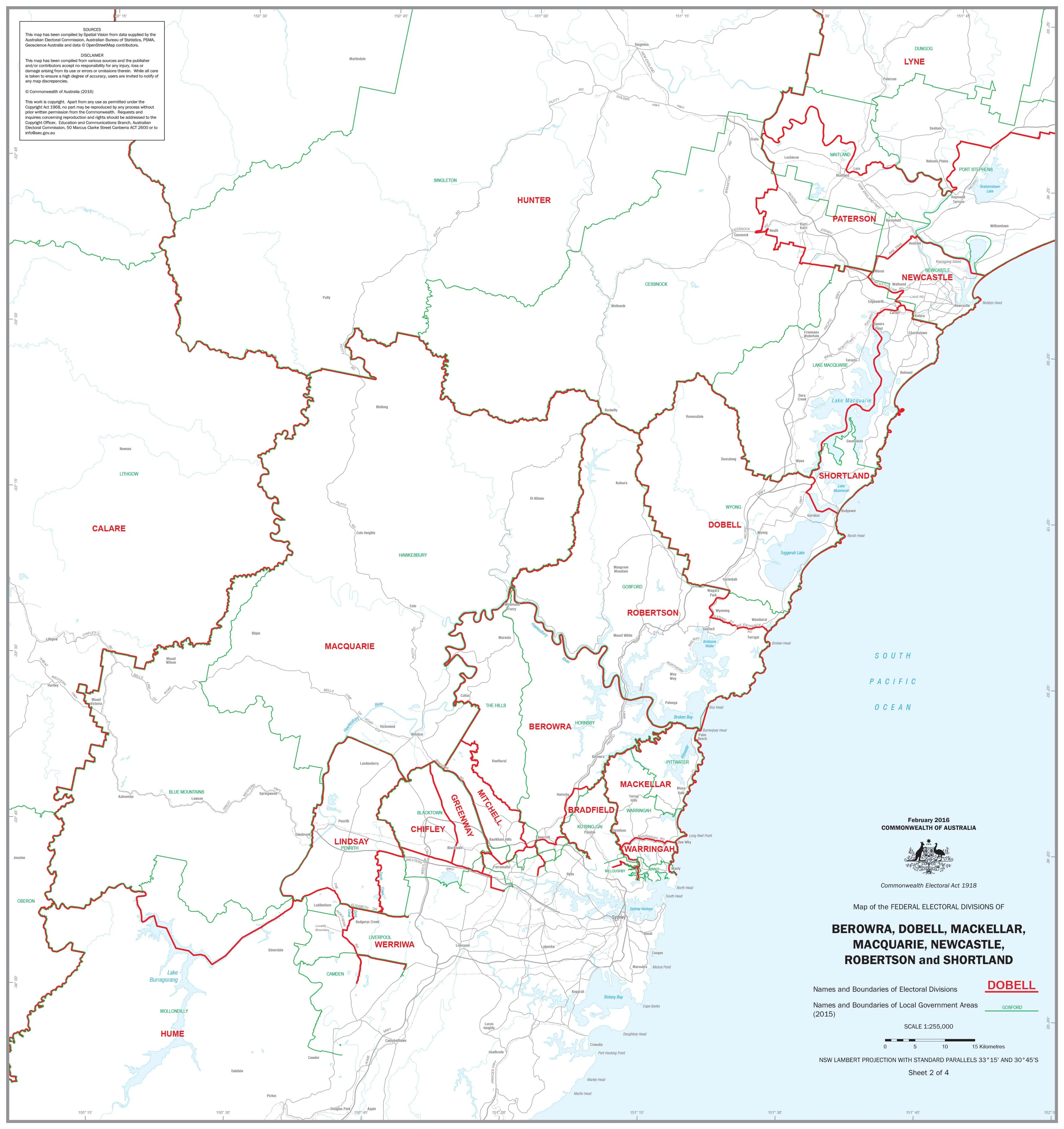
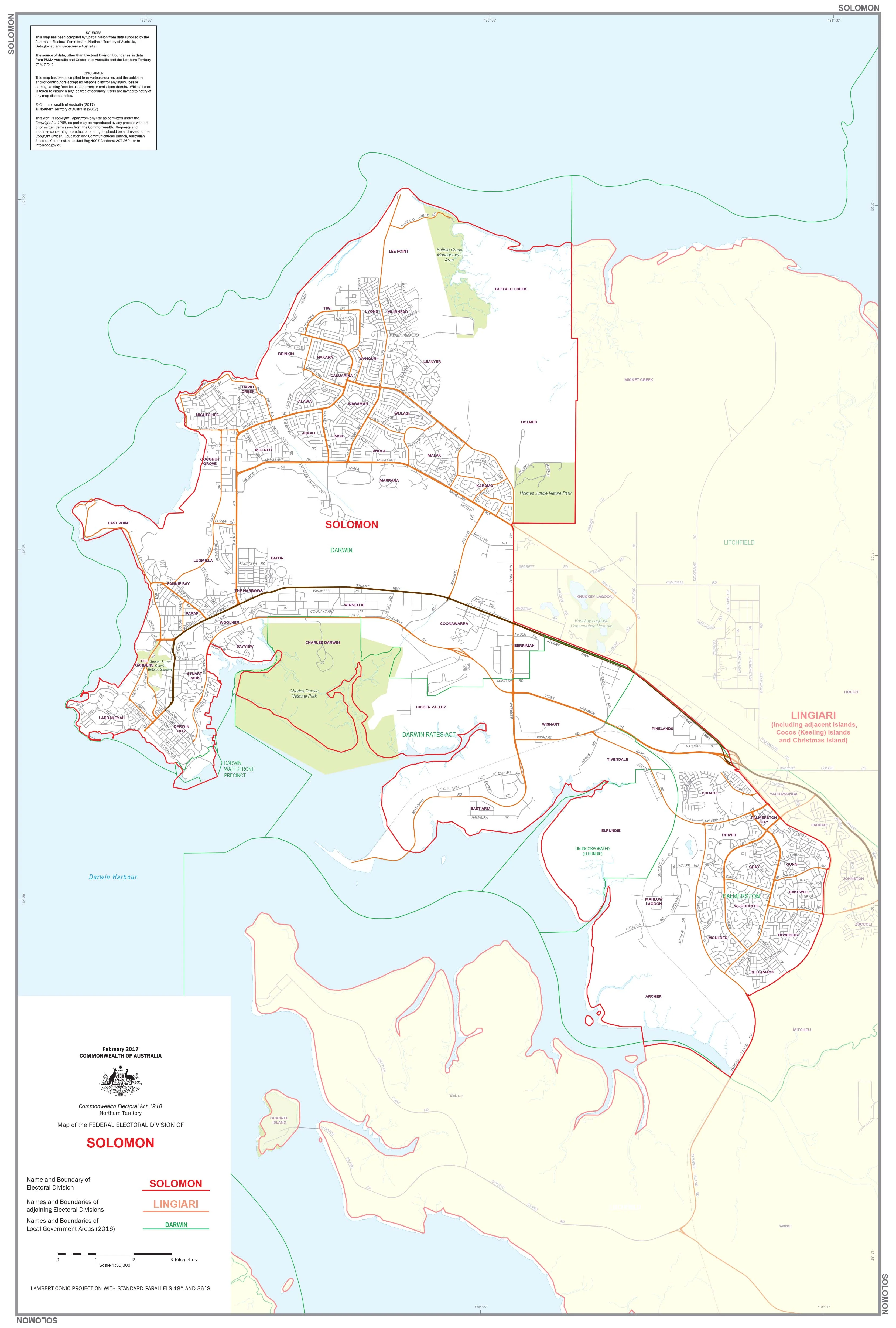
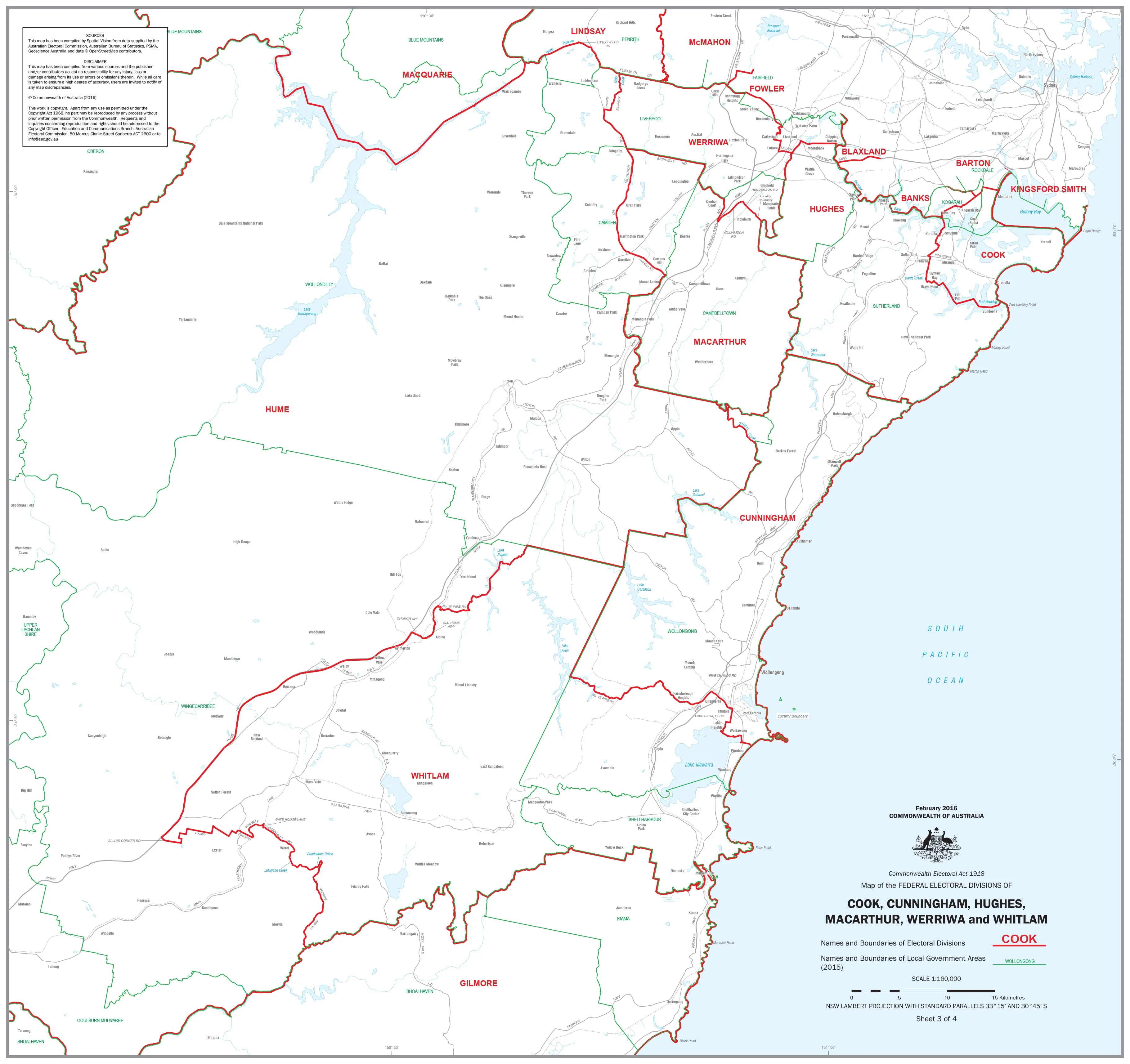
This detailed and professionally produced wall map presents the Federal Electoral Divisions and Local Government Areas (LGAs) across a broad section of New South Wales, including the Riverina and surrounding federal seats. It is an essential resource for educators, political analysts, regional planners, public servants, campaigners, or anyone working with electoral or civic boundaries.
The map clearly shows the names and boundaries of both the federal electoral divisions and the local government areas, helping users visualise how constituencies and councils overlap across this significant region of NSW.
🗺️ Coverage Includes the Following Divisions:
-
Calare
-
Cowper
-
Eden-Monaro
-
Farrer
-
Gilmore
-
Hume
-
Hunter
-
Lyne
-
New England
-
Page
-
Parkes
-
Paterson
-
Richmond
-
Riverina
📌 Map Features
-
Clearly defined federal electoral boundaries
-
Overlaid local government area boundaries with full naming
-
Accurate and up-to-date political geography
-
Ideal for offices, classrooms, polling stations, and council facilities
-
Designed for reference, planning, electoral logistics, and display
📐 Specifications
| Attribute | Detail |
|---|---|
| Title | NSW Federal Divisions & LGAs – Riverina & Area |
| Size | 1000 mm (W) x 700 mm (H) |
| Format | Flat, large-format wall map |
| Custom Maps | Individual maps of each electoral division available upon request |
🖨️ Available Finishes
| Format | Description |
|---|---|
| 160gsm Paper | Premium heavyweight matte paper – ideal for framing under glass |
| Encapsulated Laminate | Gloss-finished and sealed between two layers of 80-micron laminate – durable, waterproof, and writable with dry-erase markers |
| 395gsm Matte Canvas | Printed on museum-quality canvas with fade-resistant pigment inks – perfect for long-term display or professional presentation |
Optional Timber Hang Rails (Laminaed & Canvas Only)
Canvas maps can be mounted with natural timber hang rails, top and bottom, with a sturdy hanging cord affixed. Easy to install—just add a hook.
⏳ Please allow up to 10 business days for delivery of hang-railed maps, as these are custom-mounted by our framer.
✅ Why Choose This Map?
| Feature | Benefit |
|---|---|
| Covers 14 major federal divisions | Broad political geography from coast to inland NSW |
| Dual boundary data (Divisions & LGAs) | Great for education, logistics, or electoral planning |
| High-quality print options | Paper, laminated, or canvas – choose your finish |
| Custom mapping available | We can provide individual maps for any federal division – contact us for details |
Ideal for schools, political offices, electoral commissions, council buildings, or business planning, this map is a practical, informative, and well-designed reference for anyone engaging with the political landscape of New South Wales.
Product Information
Product Information
Shipping & Returns
Shipping & Returns
Description
Detailed Political Boundaries Across Eastern and Inland New South Wales
This detailed and professionally produced wall map presents the Federal Electoral Divisions and Local Government Areas (LGAs) across a broad section of New South Wales, including the Riverina and surrounding federal seats. It is an essential resource for educators, political analysts, regional planners, public servants, campaigners, or anyone working with electoral or civic boundaries.
The map clearly shows the names and boundaries of both the federal electoral divisions and the local government areas, helping users visualise how constituencies and councils overlap across this significant region of NSW.
🗺️ Coverage Includes the Following Divisions:
-
Calare
-
Cowper
-
Eden-Monaro
-
Farrer
-
Gilmore
-
Hume
-
Hunter
-
Lyne
-
New England
-
Page
-
Parkes
-
Paterson
-
Richmond
-
Riverina
📌 Map Features
-
Clearly defined federal electoral boundaries
-
Overlaid local government area boundaries with full naming
-
Accurate and up-to-date political geography
-
Ideal for offices, classrooms, polling stations, and council facilities
-
Designed for reference, planning, electoral logistics, and display
📐 Specifications
| Attribute | Detail |
|---|---|
| Title | NSW Federal Divisions & LGAs – Riverina & Area |
| Size | 1000 mm (W) x 700 mm (H) |
| Format | Flat, large-format wall map |
| Custom Maps | Individual maps of each electoral division available upon request |
🖨️ Available Finishes
| Format | Description |
|---|---|
| 160gsm Paper | Premium heavyweight matte paper – ideal for framing under glass |
| Encapsulated Laminate | Gloss-finished and sealed between two layers of 80-micron laminate – durable, waterproof, and writable with dry-erase markers |
| 395gsm Matte Canvas | Printed on museum-quality canvas with fade-resistant pigment inks – perfect for long-term display or professional presentation |
Optional Timber Hang Rails (Laminaed & Canvas Only)
Canvas maps can be mounted with natural timber hang rails, top and bottom, with a sturdy hanging cord affixed. Easy to install—just add a hook.
⏳ Please allow up to 10 business days for delivery of hang-railed maps, as these are custom-mounted by our framer.
✅ Why Choose This Map?
| Feature | Benefit |
|---|---|
| Covers 14 major federal divisions | Broad political geography from coast to inland NSW |
| Dual boundary data (Divisions & LGAs) | Great for education, logistics, or electoral planning |
| High-quality print options | Paper, laminated, or canvas – choose your finish |
| Custom mapping available | We can provide individual maps for any federal division – contact us for details |
Ideal for schools, political offices, electoral commissions, council buildings, or business planning, this map is a practical, informative, and well-designed reference for anyone engaging with the political landscape of New South Wales.