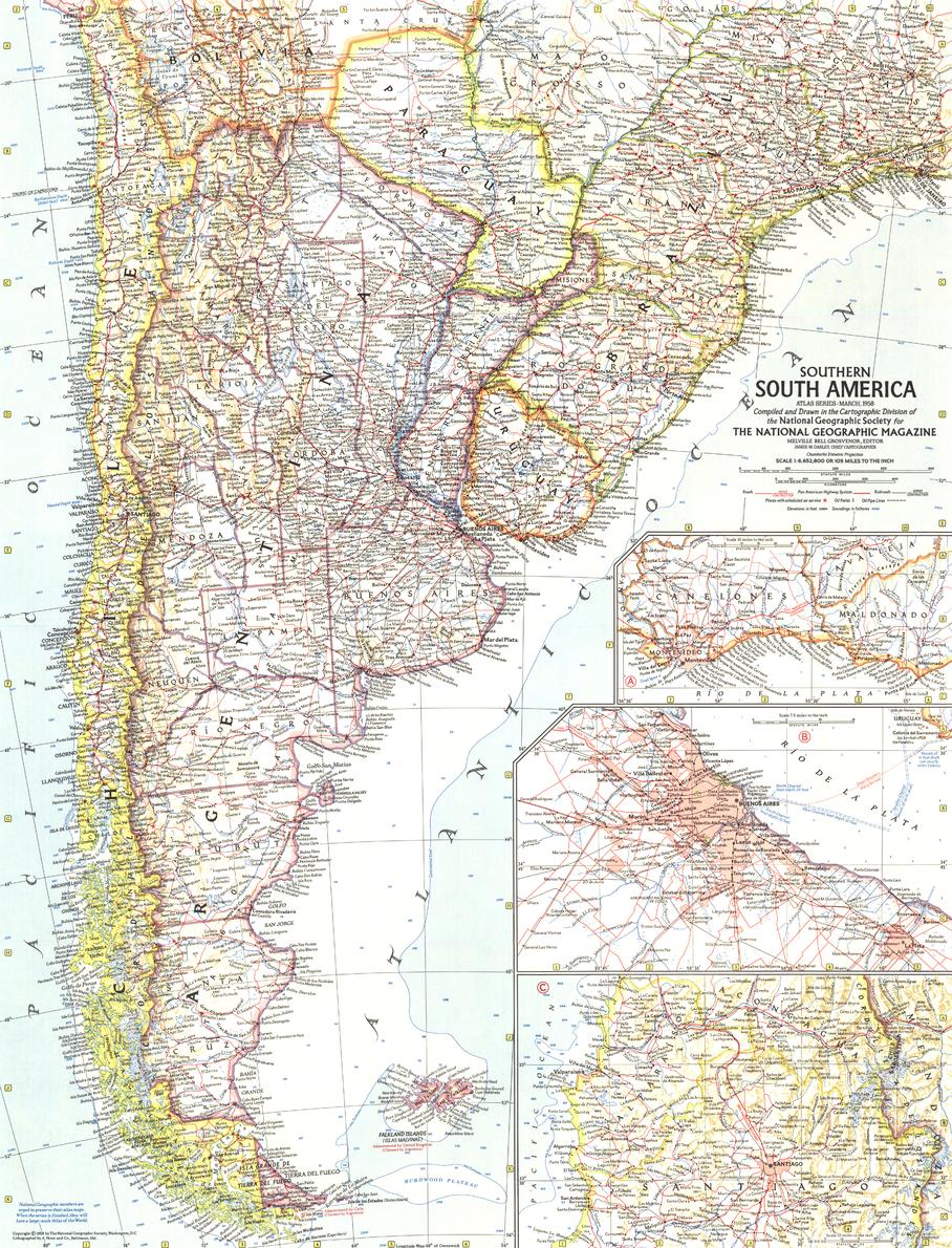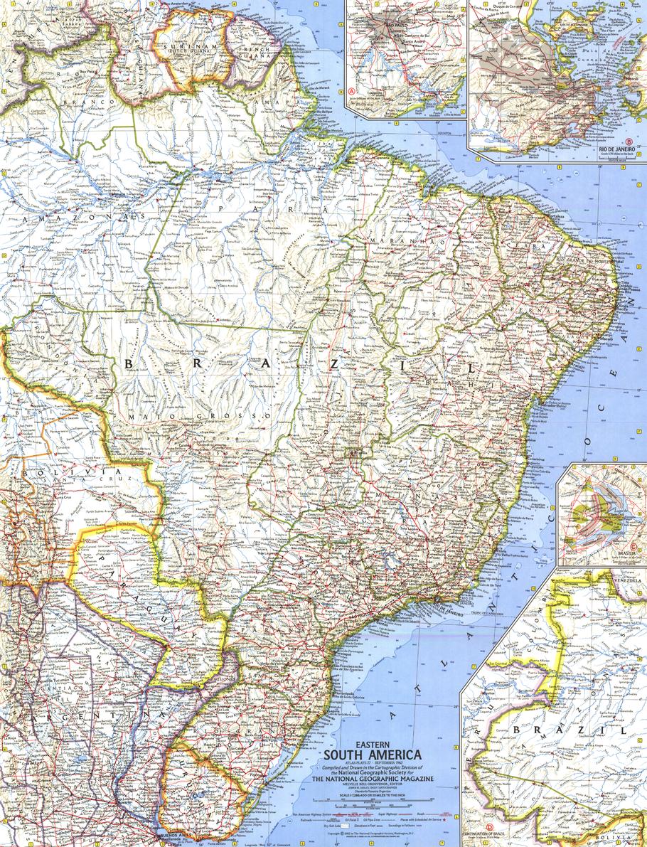
Eastern South America Wall Map - Published 1962 by National Geographic
Size: 481 × 630 mm | Scale: 1:7,286,400 | Published: 1962 | Made in Australia
🌍 A 1960s Portrait of a Changing Continent
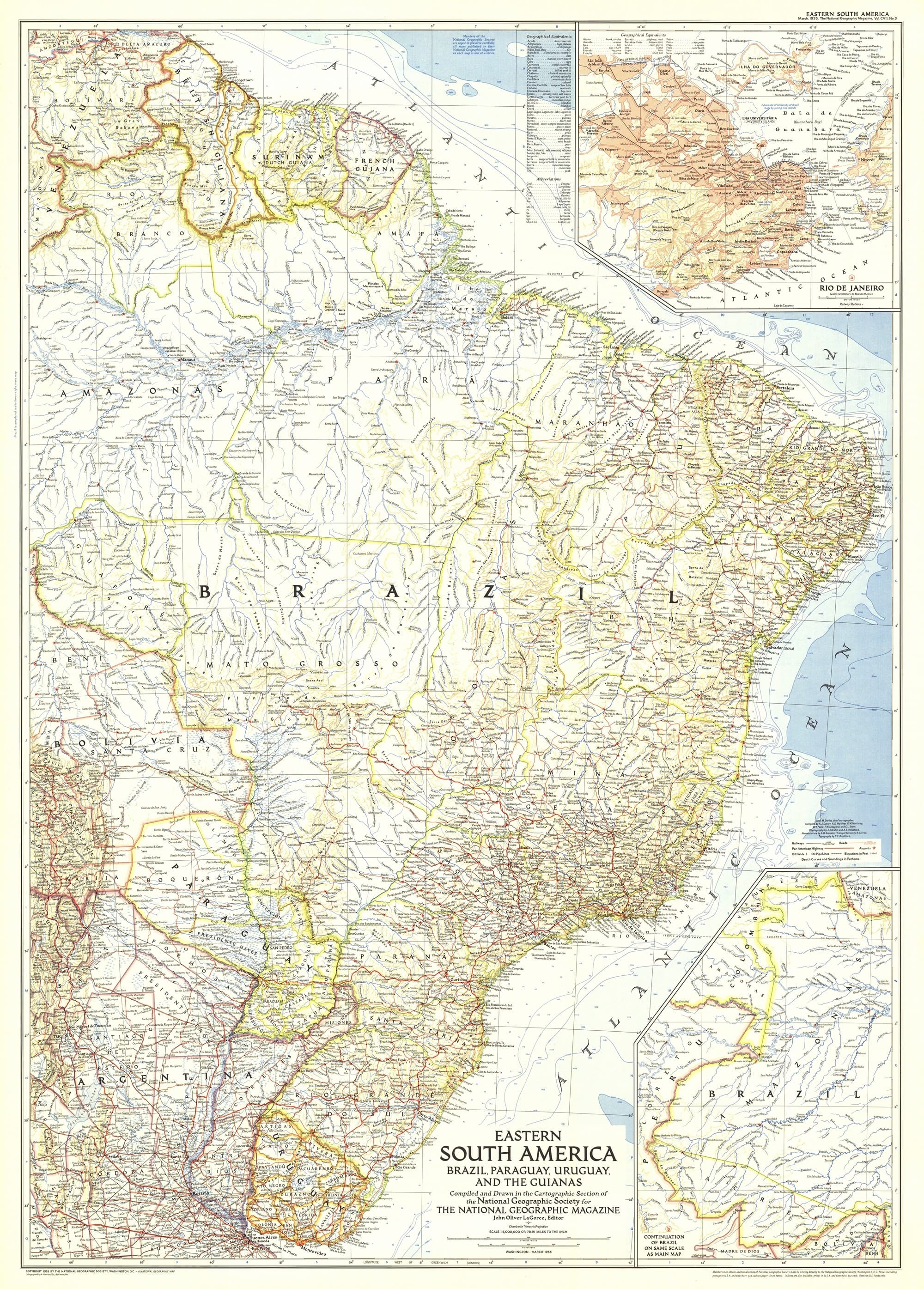
Step back to September 1962, when the vibrancy of Eastern South America was captured in rich National Geographic colour and precise mid-century cartography. This exceptional wall map was released alongside the feature article “Brazil, Oba!”, celebrating the nation’s energy, optimism, and cultural heartbeat during a decade of transformation.
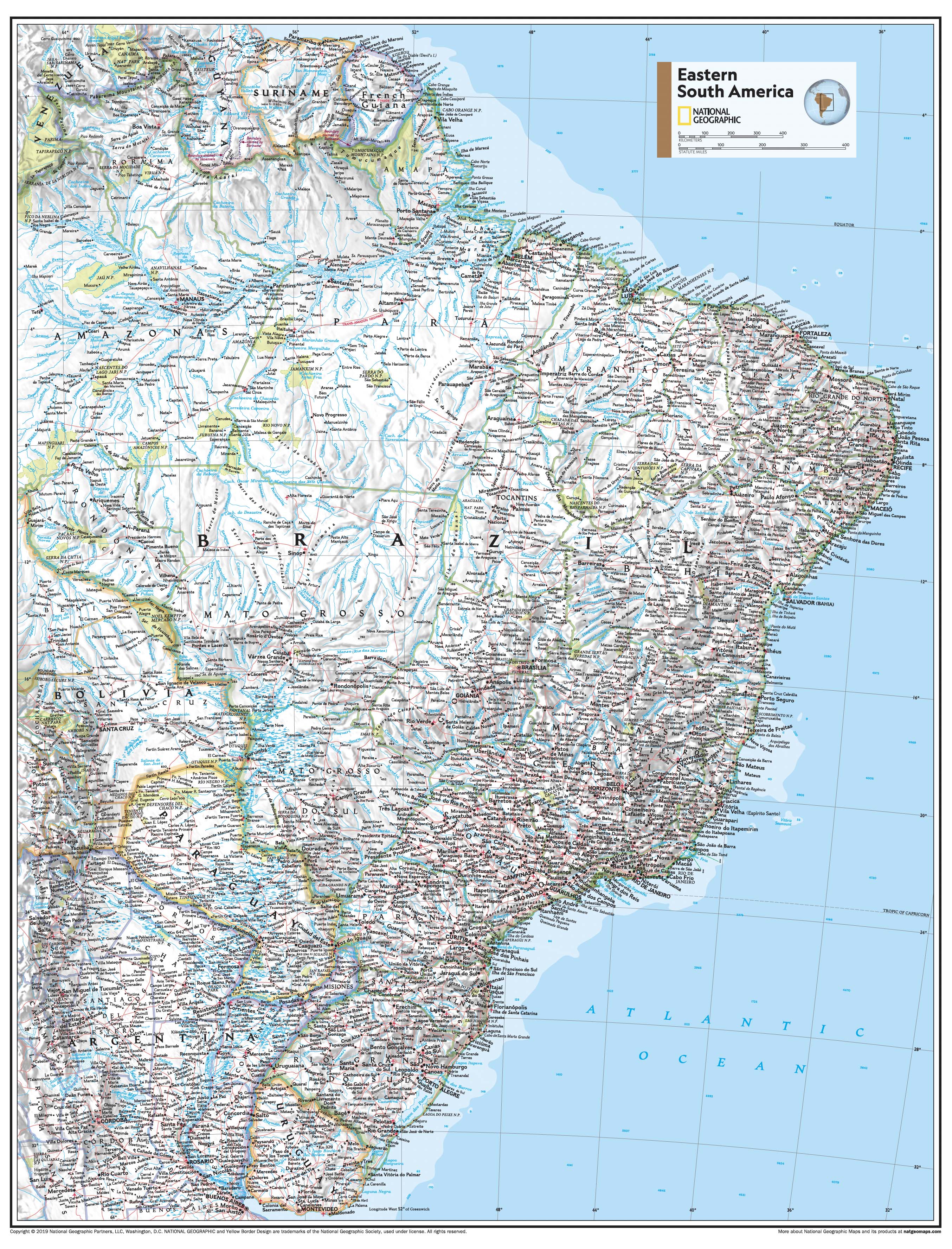
The map is meticulously detailed, covering the eastern expanse of the continent with a focus on Brazil’s diverse landscapes—from the sweeping Amazon Basin to the Atlantic coastline dotted with thriving port cities.
Three beautifully illustrated inset maps provide close-up views of Brazil’s key urban centres:
-
Brasília – the newly inaugurated capital, a bold modernist experiment rising from the interior savanna.
-
Rio de Janeiro – a breathtaking coastal jewel framed by mountains and sea.
-
São Paulo – the booming industrial and economic powerhouse of South America.
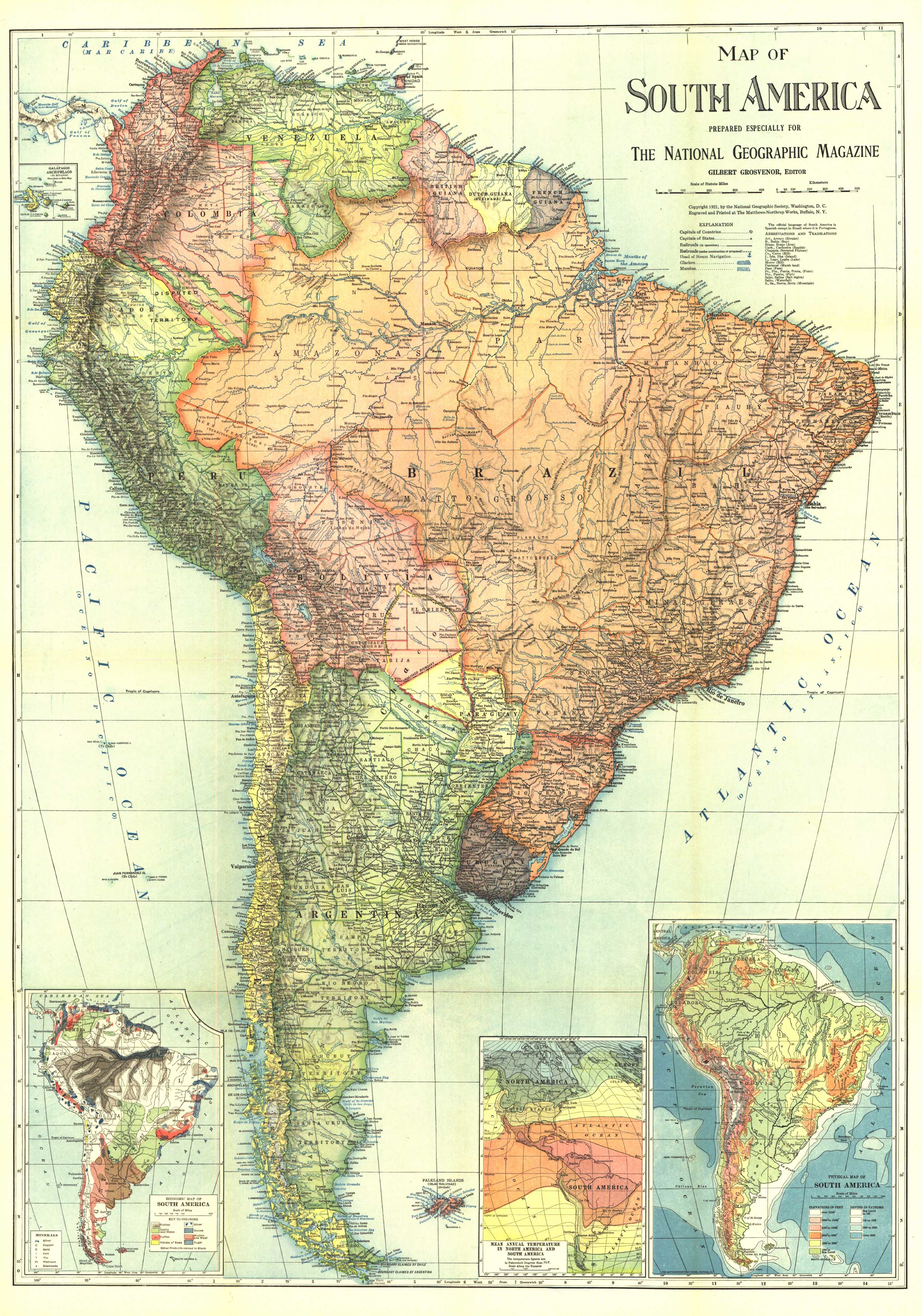
Designed as a fine companion to National Geographic’s 1964 Northwestern South America map, it forms part of a stunning two-map set that chronicles the continent during a pivotal period in its history.
📐 Cartographic Features
-
Inset Maps: Brasília, Rio de Janeiro, and São Paulo.
-
Geographic Coverage: Eastern Brazil, Uruguay, Paraguay, Suriname, French Guiana, and portions of Argentina and Venezuela.
-
Detail Level: Political boundaries, major transport routes, topographic relief, rivers, coastal features, and key settlements.
-
Colouration: Vibrant yet refined, in the classic mid-century National Geographic palette.
🖌 Premium Print & Display Options
| Format | Description |
|---|---|
| Paper (160 gsm) | Heavyweight matte-coated paper – perfect for archival framing under glass. |
| Laminated | Encapsulated in two sheets of 80-micron gloss laminate for outstanding durability and water resistance. |
| Laminated + Hang Rails | Laminated map with smooth natural timber rails and a hanging cord – display-ready on arrival. |
| Canvas (395 gsm) | Printed on HP Professional Matte Canvas using archival pigment inks for rich texture and fade resistance. |
| Canvas + Hang Rails | Canvas map finished with natural timber hang rails for a timeless, heritage-style presentation. |
Note: Please allow up to 10 working days for delivery of hang-railed maps, as each is professionally mounted by our framer.
🎯 Perfect For
-
Map Collectors – An authentic reproduction of a 1960s National Geographic classic.
-
Brazil Enthusiasts – See Brazil’s urban and rural landscapes at a key historical moment.
-
Educators & Historians – A valuable resource for teaching South American political and cultural geography of the era.
-
Interior Design – A striking conversation piece for libraries, studies, offices, or travel-themed spaces.
🌟 Why This Map Stands Out
-
Historic Provenance – Published alongside one of National Geographic’s most celebratory features on Brazil.
-
Urban Insets – Detailed city plans offering rare mid-century cartographic perspectives of Brazil’s major cities.
-
Exceptional Print Quality – Crisp, vibrant, and designed to endure.
-
Australian Made – Printed locally to professional archival standards.
Celebrate the colour, energy, and geography of Eastern South America in the 1960s. This National Geographic wall map captures a moment in time when Brazil was redefining itself on the global stage, offering a compelling blend of artistry, accuracy, and history.
📍 Order yours today to own a museum-quality reproduction of one of the most beautiful South American maps ever published.
Original: $50.05
-65%$50.05
$17.52Product Information
Product Information
Shipping & Returns
Shipping & Returns
Description
Size: 481 × 630 mm | Scale: 1:7,286,400 | Published: 1962 | Made in Australia
🌍 A 1960s Portrait of a Changing Continent
Step back to September 1962, when the vibrancy of Eastern South America was captured in rich National Geographic colour and precise mid-century cartography. This exceptional wall map was released alongside the feature article “Brazil, Oba!”, celebrating the nation’s energy, optimism, and cultural heartbeat during a decade of transformation.
The map is meticulously detailed, covering the eastern expanse of the continent with a focus on Brazil’s diverse landscapes—from the sweeping Amazon Basin to the Atlantic coastline dotted with thriving port cities.
Three beautifully illustrated inset maps provide close-up views of Brazil’s key urban centres:
-
Brasília – the newly inaugurated capital, a bold modernist experiment rising from the interior savanna.
-
Rio de Janeiro – a breathtaking coastal jewel framed by mountains and sea.
-
São Paulo – the booming industrial and economic powerhouse of South America.
Designed as a fine companion to National Geographic’s 1964 Northwestern South America map, it forms part of a stunning two-map set that chronicles the continent during a pivotal period in its history.
📐 Cartographic Features
-
Inset Maps: Brasília, Rio de Janeiro, and São Paulo.
-
Geographic Coverage: Eastern Brazil, Uruguay, Paraguay, Suriname, French Guiana, and portions of Argentina and Venezuela.
-
Detail Level: Political boundaries, major transport routes, topographic relief, rivers, coastal features, and key settlements.
-
Colouration: Vibrant yet refined, in the classic mid-century National Geographic palette.
🖌 Premium Print & Display Options
| Format | Description |
|---|---|
| Paper (160 gsm) | Heavyweight matte-coated paper – perfect for archival framing under glass. |
| Laminated | Encapsulated in two sheets of 80-micron gloss laminate for outstanding durability and water resistance. |
| Laminated + Hang Rails | Laminated map with smooth natural timber rails and a hanging cord – display-ready on arrival. |
| Canvas (395 gsm) | Printed on HP Professional Matte Canvas using archival pigment inks for rich texture and fade resistance. |
| Canvas + Hang Rails | Canvas map finished with natural timber hang rails for a timeless, heritage-style presentation. |
Note: Please allow up to 10 working days for delivery of hang-railed maps, as each is professionally mounted by our framer.
🎯 Perfect For
-
Map Collectors – An authentic reproduction of a 1960s National Geographic classic.
-
Brazil Enthusiasts – See Brazil’s urban and rural landscapes at a key historical moment.
-
Educators & Historians – A valuable resource for teaching South American political and cultural geography of the era.
-
Interior Design – A striking conversation piece for libraries, studies, offices, or travel-themed spaces.
🌟 Why This Map Stands Out
-
Historic Provenance – Published alongside one of National Geographic’s most celebratory features on Brazil.
-
Urban Insets – Detailed city plans offering rare mid-century cartographic perspectives of Brazil’s major cities.
-
Exceptional Print Quality – Crisp, vibrant, and designed to endure.
-
Australian Made – Printed locally to professional archival standards.
Celebrate the colour, energy, and geography of Eastern South America in the 1960s. This National Geographic wall map captures a moment in time when Brazil was redefining itself on the global stage, offering a compelling blend of artistry, accuracy, and history.
📍 Order yours today to own a museum-quality reproduction of one of the most beautiful South American maps ever published.