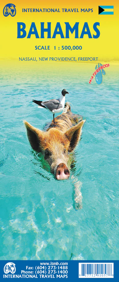
Bahamas ITMB Map
Explore the Islands of the Bahamas with This Waterproof, Adventure-Ready Map
🌴 Discover the Best of the Bahamas
From the shimmering blue shallows of the Exumas to the pink sand beaches of Harbour Island, the Bahamas ITMB Travel Map is your trusted companion for navigating one of the world's most captivating archipelagos. Whether you're sailing, diving, or soaking up the sun in a hammock, this map delivers essential travel detail across all major islands and lesser-known cays.
Now in its 5th edition, this updated and refined map covers the full chain of islands with clear road networks, ferry routes, resorts, beaches, and points of interest.
🧭 Map Features
| ✔️ | Key Highlights |
|---|---|
| 🗺️ | Double-sided layout: East half / West half for maximum legibility |
| 📍 | Inset city maps of Nassau and Freeport for urban navigation |
| 🏖️ | Detailed map of New Providence Island, the heart of Bahamian tourism |
| ⭐ | Top Attractions list included—perfect for trip planning |
| 🏨 | Resorts, marinas, and accommodations clearly marked |
| 🛥️ | Ferry routes and inter-island connections shown |
| 🌐 | Tourist icons for cultural sites, snorkelling spots, and national parks |
| 💧 | Printed on waterproof, tear-resistant synthetic paper for tropical travel durability |
📐 Map Specifications
| Specification | Details |
|---|---|
| Map Title | Bahamas ITMB Travel Map – 5th Edition |
| Map Type | Folded, double-sided travel reference |
| Map Scale | Varies by region (approx. 1:500,000) |
| Unfolded Size | 990 mm (W) × 680 mm (H) |
| Paper | Waterproof, tear-resistant synthetic stock |
| Inset Maps | Nassau, Freeport, New Providence Island |
| Top Attractions List | Included |
| Publisher | ITMB (International Travel Maps) |
🧳 Perfect For:
-
🏝️ Island hoppers planning multi-stop adventures across the Bahamas
-
🛳️ Cruise travellers seeking more than just a shore excursion
-
🐠 Divers, snorkellers & sailors exploring reefs, wrecks, and marine parks
-
📍 Independent travellers and explorers needing accurate, compact navigation
-
🎁 Gifts or educational tools for geography lovers or Caribbean enthusiasts
💡 Why Choose ITMB?
International Travel Maps are known for their practical travel-focused detail, user-friendly layout, and durable materials designed for real-world use. Whether you're charting your own adventure or just dreaming of turquoise waters, this map is both informative and inspiring.
Product Information
Product Information
Shipping & Returns
Shipping & Returns
Description
Explore the Islands of the Bahamas with This Waterproof, Adventure-Ready Map
🌴 Discover the Best of the Bahamas
From the shimmering blue shallows of the Exumas to the pink sand beaches of Harbour Island, the Bahamas ITMB Travel Map is your trusted companion for navigating one of the world's most captivating archipelagos. Whether you're sailing, diving, or soaking up the sun in a hammock, this map delivers essential travel detail across all major islands and lesser-known cays.
Now in its 5th edition, this updated and refined map covers the full chain of islands with clear road networks, ferry routes, resorts, beaches, and points of interest.
🧭 Map Features
| ✔️ | Key Highlights |
|---|---|
| 🗺️ | Double-sided layout: East half / West half for maximum legibility |
| 📍 | Inset city maps of Nassau and Freeport for urban navigation |
| 🏖️ | Detailed map of New Providence Island, the heart of Bahamian tourism |
| ⭐ | Top Attractions list included—perfect for trip planning |
| 🏨 | Resorts, marinas, and accommodations clearly marked |
| 🛥️ | Ferry routes and inter-island connections shown |
| 🌐 | Tourist icons for cultural sites, snorkelling spots, and national parks |
| 💧 | Printed on waterproof, tear-resistant synthetic paper for tropical travel durability |
📐 Map Specifications
| Specification | Details |
|---|---|
| Map Title | Bahamas ITMB Travel Map – 5th Edition |
| Map Type | Folded, double-sided travel reference |
| Map Scale | Varies by region (approx. 1:500,000) |
| Unfolded Size | 990 mm (W) × 680 mm (H) |
| Paper | Waterproof, tear-resistant synthetic stock |
| Inset Maps | Nassau, Freeport, New Providence Island |
| Top Attractions List | Included |
| Publisher | ITMB (International Travel Maps) |
🧳 Perfect For:
-
🏝️ Island hoppers planning multi-stop adventures across the Bahamas
-
🛳️ Cruise travellers seeking more than just a shore excursion
-
🐠 Divers, snorkellers & sailors exploring reefs, wrecks, and marine parks
-
📍 Independent travellers and explorers needing accurate, compact navigation
-
🎁 Gifts or educational tools for geography lovers or Caribbean enthusiasts
💡 Why Choose ITMB?
International Travel Maps are known for their practical travel-focused detail, user-friendly layout, and durable materials designed for real-world use. Whether you're charting your own adventure or just dreaming of turquoise waters, this map is both informative and inspiring.