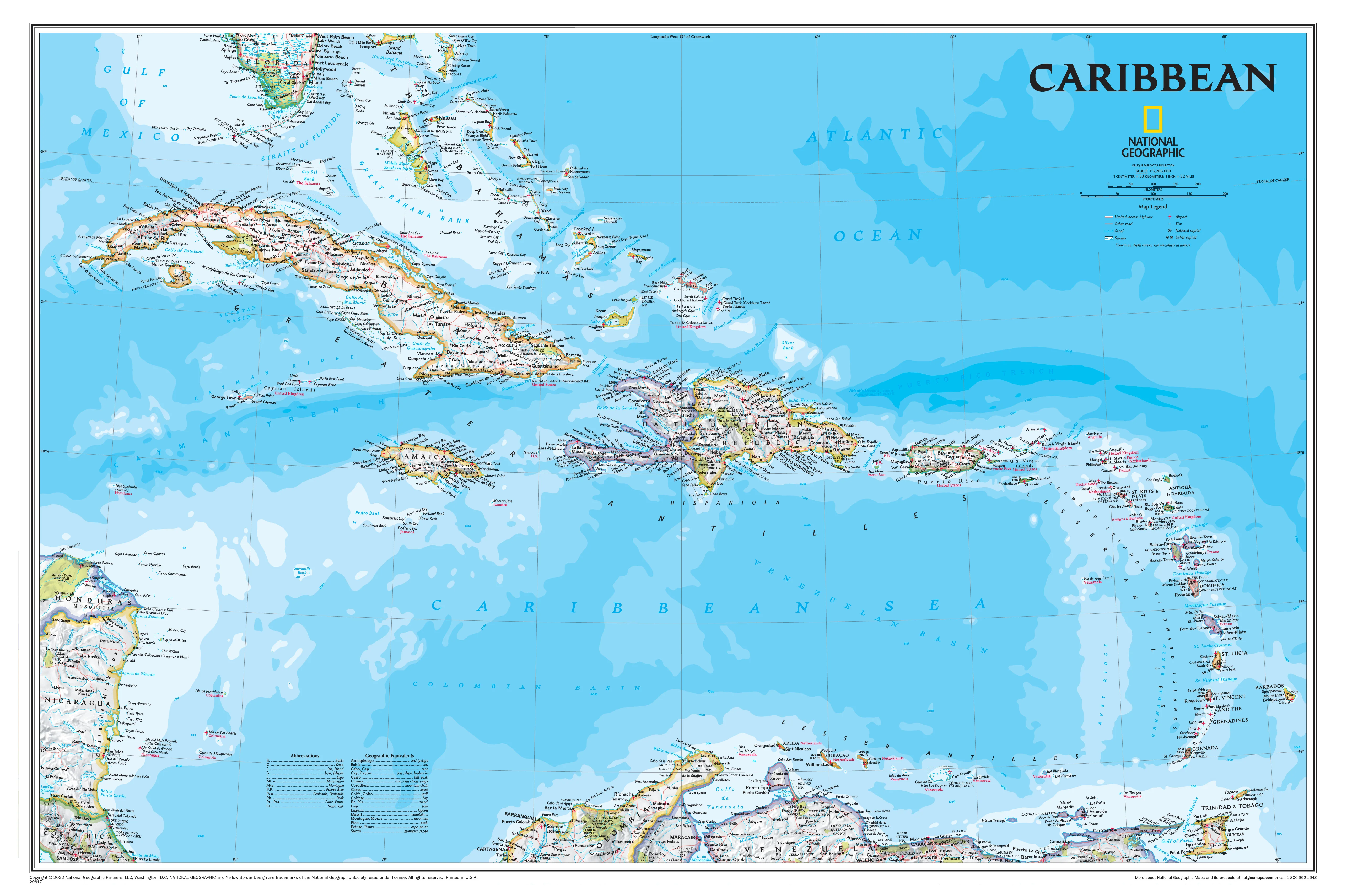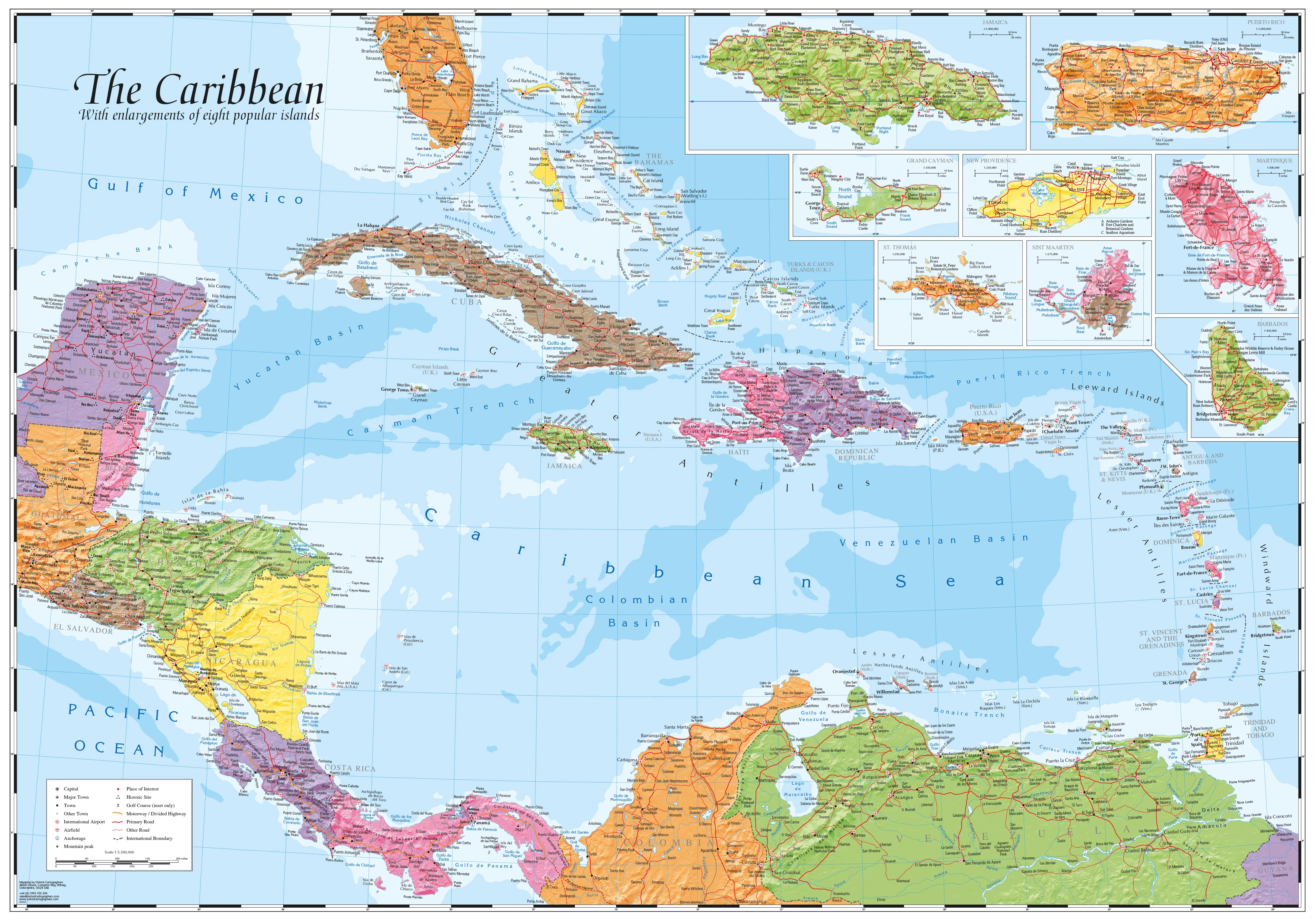
Caribbean & Main Islands by Oxford Cartographers 1000 x 690mm Wall Map
Decorative Hill-Shaded Map with Inset Islands • Available in Paper, Laminated, Canvas & Timber-Hung Formats
Scale: 1:3,500,000 | Size: 1000 mm (W) x 690 mm (H) | Made in Australia
Discover the beauty, history, and topography of the Caribbean with this stunning Caribbean & Main Islands Wall Map by Oxford Cartographers. Combining elegant hill-shaded relief with eight detailed island insets, this map offers a complete visual guide to the Caribbean Basin—from Cuba and Puerto Rico to Trinidad, Barbados, and the Bahamas.
Whether you’re a traveller, educator, cruise lover, or interior designer, this map brings function and flair to any space. Available in a range of premium finishes—including canvas with natural timber hang rails—you can choose the perfect version to suit your needs and style.
🏝️ Features & Coverage
-
Scale: 1:3,500,000 – ideal for regional overview and travel planning
-
Hill-shading & bathymetry – showing both land elevation and seafloor contours
-
Clear labelling of capitals, major towns, coastlines, and international borders
-
Surrounding mainland coasts of Central and South America included
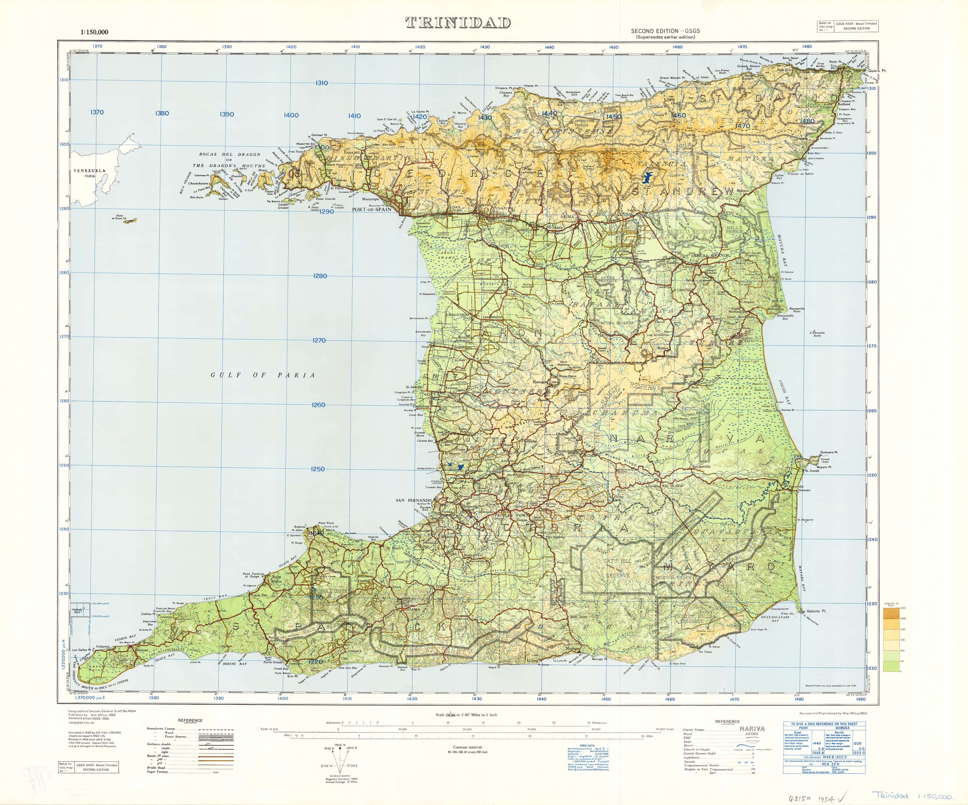
📍 Inset Maps of 8 Key Caribbean Islands:
-
Barbados
-
Jamaica
-
Cuba
-
Puerto Rico
-
Saint Lucia
-
Trinidad
-
Saint Kitts & Nevis
-
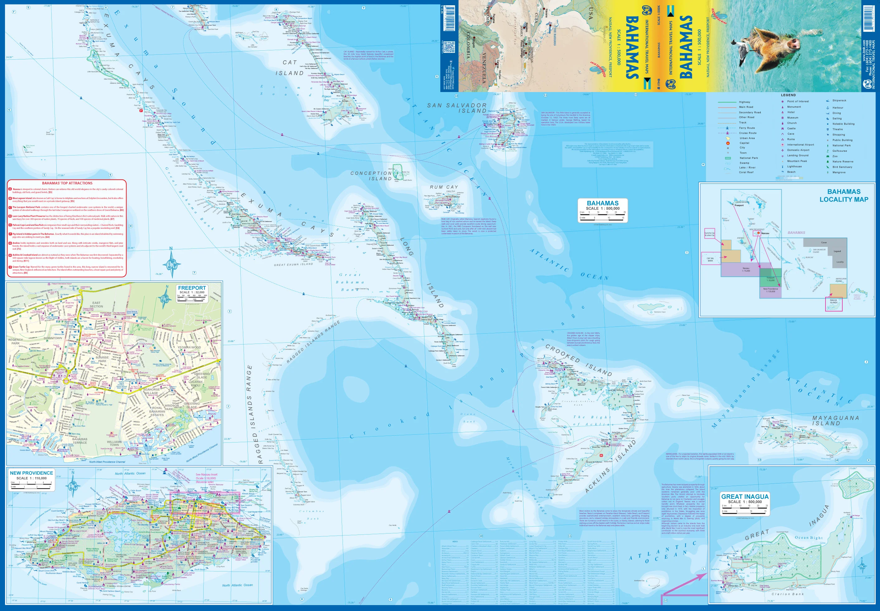
The Bahamas
Each inset includes topographic detail, major towns, resort areas, and travel points of interest.
🧭 Available Formats
| Format | Description |
|---|---|
| 📄 Paper (160gsm) | Premium matte finish, ideal for framing under glass |
| 🛡️ Laminated | Gloss-laminated front and back for durability, stain resistance, and whiteboard use |
| 🖼️ Canvas (395gsm) | Printed on heavyweight HP Matte Canvas with fade-resistant pigment inks for rich colour |
| 🪵 Laminated + Hang Rails | Laminated map mounted with natural timber hang rails and hanging cord – ready to display |
| 🪵 Canvas + Hang Rails | Archival canvas with timber hang rails top and bottom, plus cord for effortless wall hanging |
🪵 Timber Hang Rail Options (Laminated & Canvas)
Both laminated and canvas versions are available with optional timber hang rails for a gallery-style finish:
-
🪵 Natural timber rails, lacquered for smoothness and durability
-
🧵 Pre-attached hanging cord – just place a hook in the wall and you’re done
-
🧷 No framing required – a clean, professional look that’s easy to update or relocate
-
💧 Laminated versions are whiteboard marker–friendly
-
🖼️ Canvas versions are ideal for stylish interiors and long-term wall display
📦 Please allow up to 10 working days for delivery of rail-mounted maps. Each piece is carefully hand-finished by our framing team.
📐 Product Specifications
| Attribute | Detail |
|---|---|
| Title | Caribbean & Main Islands Wall Map |
| Cartographer | Oxford Cartographers |
| Scale | 1:3,500,000 |
| Size | 1000 mm (W) x 690 mm (H) |
| Inset Islands | 8 islands: Cuba, Jamaica, Barbados, Puerto Rico, St. Lucia, Trinidad, St. Kitts & Nevis, The Bahamas |
| Finishes Available | Paper • Laminated • Canvas • Laminated + Rails • Canvas + Rails |
| Print Quality | Full-colour, hill-shaded, highly legible cartography |
| Made In | Australia |
🎯 Ideal For:
-
🛳️ Cruise travellers & island hoppers
-
🌍 World travellers planning Caribbean adventures
-
🏫 Teachers & students studying regional geography
-
🏡 Interior decorators & home stylists seeking a tropical feature piece
-
🗺️ Map collectors looking to expand their global wall map collection
-
🧾 Travel agencies & tourism offices wanting a professional reference map
🛒 Add to Cart – Your Caribbean Wall Statement Starts Here
From classroom to boardroom, home office to beach house, the Caribbean & Main Islands Wall Map by Oxford Cartographers brings colour, accuracy, and inspiration to your wall. Choose your preferred format above—whether for practical reference, travel planning, or decorative elegance.
Original: $42.89
-65%$42.89
$15.01Product Information
Product Information
Shipping & Returns
Shipping & Returns
Description
Decorative Hill-Shaded Map with Inset Islands • Available in Paper, Laminated, Canvas & Timber-Hung Formats
Scale: 1:3,500,000 | Size: 1000 mm (W) x 690 mm (H) | Made in Australia
Discover the beauty, history, and topography of the Caribbean with this stunning Caribbean & Main Islands Wall Map by Oxford Cartographers. Combining elegant hill-shaded relief with eight detailed island insets, this map offers a complete visual guide to the Caribbean Basin—from Cuba and Puerto Rico to Trinidad, Barbados, and the Bahamas.
Whether you’re a traveller, educator, cruise lover, or interior designer, this map brings function and flair to any space. Available in a range of premium finishes—including canvas with natural timber hang rails—you can choose the perfect version to suit your needs and style.
🏝️ Features & Coverage
-
Scale: 1:3,500,000 – ideal for regional overview and travel planning
-
Hill-shading & bathymetry – showing both land elevation and seafloor contours
-
Clear labelling of capitals, major towns, coastlines, and international borders
-
Surrounding mainland coasts of Central and South America included
📍 Inset Maps of 8 Key Caribbean Islands:
-
Barbados
-
Jamaica
-
Cuba
-
Puerto Rico
-
Saint Lucia
-
Trinidad
-
Saint Kitts & Nevis
-
The Bahamas
Each inset includes topographic detail, major towns, resort areas, and travel points of interest.
🧭 Available Formats
| Format | Description |
|---|---|
| 📄 Paper (160gsm) | Premium matte finish, ideal for framing under glass |
| 🛡️ Laminated | Gloss-laminated front and back for durability, stain resistance, and whiteboard use |
| 🖼️ Canvas (395gsm) | Printed on heavyweight HP Matte Canvas with fade-resistant pigment inks for rich colour |
| 🪵 Laminated + Hang Rails | Laminated map mounted with natural timber hang rails and hanging cord – ready to display |
| 🪵 Canvas + Hang Rails | Archival canvas with timber hang rails top and bottom, plus cord for effortless wall hanging |
🪵 Timber Hang Rail Options (Laminated & Canvas)
Both laminated and canvas versions are available with optional timber hang rails for a gallery-style finish:
-
🪵 Natural timber rails, lacquered for smoothness and durability
-
🧵 Pre-attached hanging cord – just place a hook in the wall and you’re done
-
🧷 No framing required – a clean, professional look that’s easy to update or relocate
-
💧 Laminated versions are whiteboard marker–friendly
-
🖼️ Canvas versions are ideal for stylish interiors and long-term wall display
📦 Please allow up to 10 working days for delivery of rail-mounted maps. Each piece is carefully hand-finished by our framing team.
📐 Product Specifications
| Attribute | Detail |
|---|---|
| Title | Caribbean & Main Islands Wall Map |
| Cartographer | Oxford Cartographers |
| Scale | 1:3,500,000 |
| Size | 1000 mm (W) x 690 mm (H) |
| Inset Islands | 8 islands: Cuba, Jamaica, Barbados, Puerto Rico, St. Lucia, Trinidad, St. Kitts & Nevis, The Bahamas |
| Finishes Available | Paper • Laminated • Canvas • Laminated + Rails • Canvas + Rails |
| Print Quality | Full-colour, hill-shaded, highly legible cartography |
| Made In | Australia |
🎯 Ideal For:
-
🛳️ Cruise travellers & island hoppers
-
🌍 World travellers planning Caribbean adventures
-
🏫 Teachers & students studying regional geography
-
🏡 Interior decorators & home stylists seeking a tropical feature piece
-
🗺️ Map collectors looking to expand their global wall map collection
-
🧾 Travel agencies & tourism offices wanting a professional reference map
🛒 Add to Cart – Your Caribbean Wall Statement Starts Here
From classroom to boardroom, home office to beach house, the Caribbean & Main Islands Wall Map by Oxford Cartographers brings colour, accuracy, and inspiration to your wall. Choose your preferred format above—whether for practical reference, travel planning, or decorative elegance.