Coventry A-Z 1046 x 920mm Wall Map
A Detailed Street-Level Map of Coventry and Surrounding Suburbs
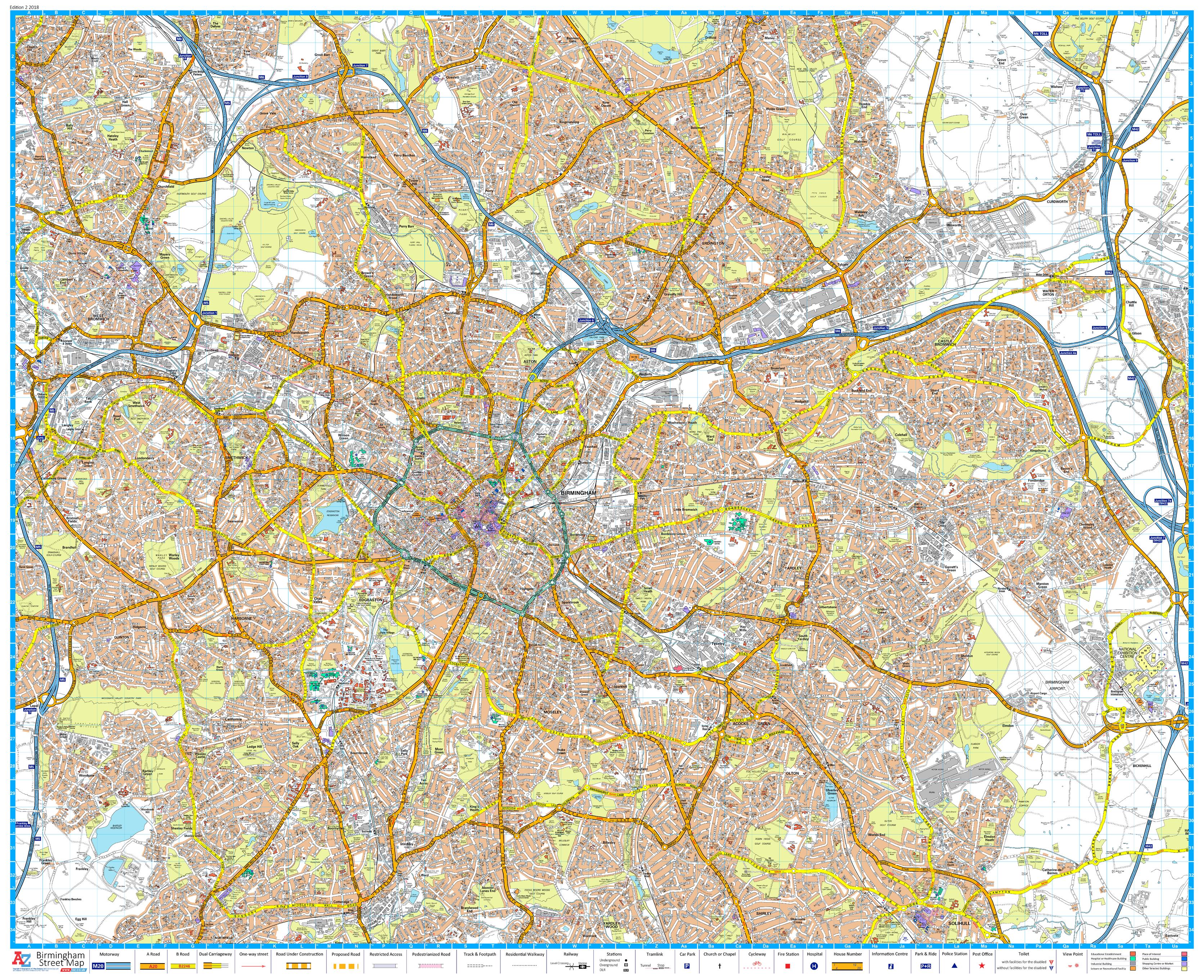
Perfect for businesses, planners, educational institutions, and proud locals, this A-Z Wall Map of Coventry delivers detailed street-level coverage of the city and surrounding areas. With the trusted cartographic style of the A-Z Mapping Company, this large-format wall map is both functional and visually impressive—ideal for offices, classrooms, or logistics hubs.
This single-sheet map provides complete coverage of Coventry’s urban layout, arterial routes, industrial zones, and residential areas—making it an invaluable planning tool and a stunning reference for display.
🏙️ Areas Included
This map includes detailed street mapping for:
-
Coventry (central and suburban)
-
Keresley Newlands
-
Coventry Airport
-
Millison's Wood
-
Tile Hill
-
M6 Junction 3
-
Walsgrave on Sowe
-
Binley Woods
-
Ryton-on-Dunsmore
📌 Map Features
| ✅ Feature | 📋 Details |
|---|---|
| A-Z Signature Cartography | Clear, full-colour street mapping |
| Complete Street Indexing | Every road, lane, and cul-de-sac is clearly labelled |
| Postcode & Suburb Coverage | Ideal for delivery zones, estate planning, and navigation |
| Single-Sheet Format | Supplied flat, not folded—ready for wall display |
| Edition | Published 2018 |
🖼️ Format Options
Choose the finish that suits your space and needs:
| 🎨 Format | 📌 Details |
|---|---|
| Paper (Unlaminated) | Ideal for framing under glass |
| Laminated | Gloss-laminated for durability and dry-erase use |
| Laminated with Hang Rails | Fitted top and bottom with wooden rails and hanging cord |
| Canvas | Printed on 395gsm professional-grade matte canvas |
| Canvas with Timber Rails | Museum-quality canvas with handcrafted wooden hang rails for elegant display |
📐 Specifications
| 📏 Specification | 📍 Details |
|---|---|
| Map Title | Coventry A-Z Wall Map |
| Publisher | Geographers’ A-Z Map Company |
| Scale | 1:12,672 |
| Dimensions | 1046 mm (W) × 920 mm (H) |
| Orientation | Landscape |
| Print Quality | High-resolution full-colour |
| Published | 2018 |
🎯 Ideal For
| 👤 User | 💼 Purpose |
|---|---|
| Business Owners | Define service areas and delivery routes |
| Estate Agents | Showcase local coverage and amenities |
| Schools & Colleges | Teach local geography with real-world context |
| Planners & Surveyors | Assess development zones and travel infrastructure |
| Proud Residents | Decorate your home or office with your city in detail |
🗺️ From the historic heart of Coventry to the outskirts of Tile Hill and Ryton-on-Dunsmore—this map puts your city on the wall with clarity and pride.
Please allow up to 10 working days for delivery of hang-railed maps, as they are custom-mounted by our professional framer.
👉 Select your preferred format and display Coventry the way it deserves to be seen.
Original: $50.05
-65%$50.05
$17.52Product Information
Product Information
Shipping & Returns
Shipping & Returns
Description
A Detailed Street-Level Map of Coventry and Surrounding Suburbs
Perfect for businesses, planners, educational institutions, and proud locals, this A-Z Wall Map of Coventry delivers detailed street-level coverage of the city and surrounding areas. With the trusted cartographic style of the A-Z Mapping Company, this large-format wall map is both functional and visually impressive—ideal for offices, classrooms, or logistics hubs.
This single-sheet map provides complete coverage of Coventry’s urban layout, arterial routes, industrial zones, and residential areas—making it an invaluable planning tool and a stunning reference for display.
🏙️ Areas Included
This map includes detailed street mapping for:
-
Coventry (central and suburban)
-
Keresley Newlands
-
Coventry Airport
-
Millison's Wood
-
Tile Hill
-
M6 Junction 3
-
Walsgrave on Sowe
-
Binley Woods
-
Ryton-on-Dunsmore
📌 Map Features
| ✅ Feature | 📋 Details |
|---|---|
| A-Z Signature Cartography | Clear, full-colour street mapping |
| Complete Street Indexing | Every road, lane, and cul-de-sac is clearly labelled |
| Postcode & Suburb Coverage | Ideal for delivery zones, estate planning, and navigation |
| Single-Sheet Format | Supplied flat, not folded—ready for wall display |
| Edition | Published 2018 |
🖼️ Format Options
Choose the finish that suits your space and needs:
| 🎨 Format | 📌 Details |
|---|---|
| Paper (Unlaminated) | Ideal for framing under glass |
| Laminated | Gloss-laminated for durability and dry-erase use |
| Laminated with Hang Rails | Fitted top and bottom with wooden rails and hanging cord |
| Canvas | Printed on 395gsm professional-grade matte canvas |
| Canvas with Timber Rails | Museum-quality canvas with handcrafted wooden hang rails for elegant display |
📐 Specifications
| 📏 Specification | 📍 Details |
|---|---|
| Map Title | Coventry A-Z Wall Map |
| Publisher | Geographers’ A-Z Map Company |
| Scale | 1:12,672 |
| Dimensions | 1046 mm (W) × 920 mm (H) |
| Orientation | Landscape |
| Print Quality | High-resolution full-colour |
| Published | 2018 |
🎯 Ideal For
| 👤 User | 💼 Purpose |
|---|---|
| Business Owners | Define service areas and delivery routes |
| Estate Agents | Showcase local coverage and amenities |
| Schools & Colleges | Teach local geography with real-world context |
| Planners & Surveyors | Assess development zones and travel infrastructure |
| Proud Residents | Decorate your home or office with your city in detail |
🗺️ From the historic heart of Coventry to the outskirts of Tile Hill and Ryton-on-Dunsmore—this map puts your city on the wall with clarity and pride.
Please allow up to 10 working days for delivery of hang-railed maps, as they are custom-mounted by our professional framer.
👉 Select your preferred format and display Coventry the way it deserves to be seen.