Hawai’i, West Idies and Bermuda - Atlas of the World, 11th Edition by National Geographic
Physical & Political Wall Map | Atlas of the World, 11th Edition (Plate 46) | Large Format (798 × 610 mm) | Premium Finishes
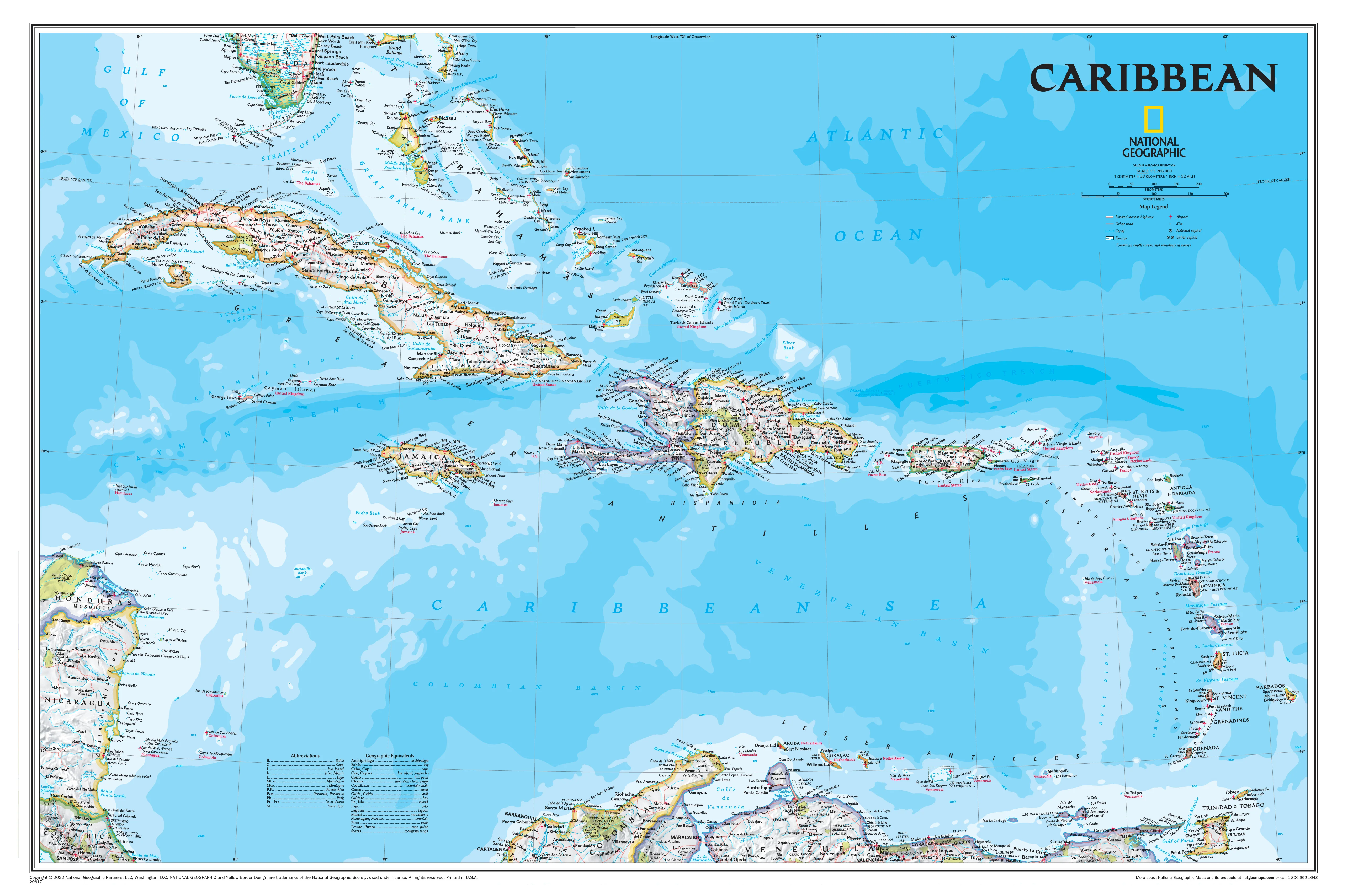
A beautifully composed map linking three iconic island regions, Hawai‘i, West Indies & Bermuda presents the Pacific and Caribbean worlds with clarity, balance, and precision. Published by National Geographic as part of the Atlas of the World, 11th Edition, this map combines physical relief and political detail in a clean, modern design.
From the volcanic islands of Hawaii to the tropical chains of the West Indies and the Atlantic outpost of Bermuda, it offers a unique multi-region perspective shaped by ocean, climate, and geography.
Why This Map Stands Out
Three regions in one elegant view
Connects the Pacific and Caribbean through a unified cartographic presentation.
Atlas-quality precision
Drawn using state-of-the-art techniques for accuracy and clarity.
Physical and political detail combined
Shows terrain, coastlines, and elevation alongside boundaries and settlements.
Exceptional readability
Clean layout and carefully placed labels make interpretation effortless.
Projection with purpose
Uses the Azimuthal Equidistant projection, preserving accurate distances from the centre point.
🗺️ What the Map Shows
- The Hawaiian island chain in the central Pacific
- The island groups of the Caribbean, including the West Indies
- The location of Bermuda in the North Atlantic
- Major islands, cities, and settlements across all regions
- Physical features including terrain, elevation, and coastal formations
- A comparative view of island geography across different oceans
📐 Size & Format
798 mm (H) × 610 mm (W)
Portrait orientation
A strong vertical format ideal for:
- Classrooms and geography education
- Offices and research environments
- Home studies and workspaces
- Interiors inspired by oceanic and island landscapes
✨ Premium Finishes
| Format | Description |
|---|---|
| 📜 Paper (160 gsm) | Heavyweight matte-coated paper—ideal for framing. Preserves crisp detail and colour balance. |
| 🧼 Laminated (Encapsulated) | Sealed in 2 × 80-micron gloss laminate. Durable, wipe-clean, and perfect for teaching environments. |
| 🪵 Laminated + Timber Hang Rails | Laminated map mounted with lacquered natural timber rails and hanging cord—ready to display. |
| 🖼️ Canvas (395 gsm HP Professional Matte) | Printed with archival pigment inks. Enhances depth and subtle terrain shading. |
| 🪵 Canvas + Timber Hang Rails | Canvas paired with timber rails for a refined, gallery-style presentation. |
🔨 Please allow up to 10 working days for professionally mounted hang-railed finishes.
📊 Specifications
| Feature | Detail |
|---|---|
| Title | Hawai‘i, West Indies & Bermuda |
| Publisher | National Geographic |
| Published | 2019 |
| Source | Atlas of the World, 11th Edition (Plate 46) |
| Scale | 1:1,077,000 |
| Dimensions | 798 mm × 610 mm |
| Orientation | Portrait |
| Projection | Azimuthal Equidistant |
| Map Type | Physical / Political |
| Coverage | Hawai‘i, Caribbean (West Indies), Bermuda |
| Collections | USA |
| Materials | 160 gsm matte paper / 2 × 80-micron laminate / 395 gsm HP Professional Matte Canvas |
| Printing | Pigment-based, fade-resistant inks |
| Origin | Printed in Australia |
🎯 Ideal For
- Students and educators of geography and island systems
- Travellers and enthusiasts of Pacific and Caribbean regions
- Collectors of National Geographic atlas maps
- Interiors seeking a clean, ocean-themed display piece
- Gift buyers looking for a unique multi-region map
🌊 Islands Across Oceans
Though separated by vast distances, these regions share common themes:
- Volcanic origins and ocean-driven landscapes
- Island chains shaped by tectonics and climate
- Unique ecosystems and cultural identities
- Strategic and historic importance across global routes
This map brings them together—offering a rare perspective on how islands define and connect our world.
🤝 Our Commitment
- Printed in Australia using archival-quality production
- Faithfully reproduced to preserve colour, clarity, and detail
- Premium materials selected for durability and long-term display
- Each map is hand-checked before dispatch
- Carefully packaged for safe delivery
🚚 Delivery
- Paper, Laminated, Canvas (rolled): Dispatch within 1–2 business days
- Hang-Railed Maps: Made to order—allow up to 10 working days
- Packaging: Securely rolled in protective tubing
Explore three ocean worlds in one refined view—
a map that brings Hawai‘i, the Caribbean, and Bermuda together with clarity and style.
👉 Order now and add a unique island perspective to your wall.
Original: $50.05
-65%$50.05
$17.52Product Information
Product Information
Shipping & Returns
Shipping & Returns
Description
Physical & Political Wall Map | Atlas of the World, 11th Edition (Plate 46) | Large Format (798 × 610 mm) | Premium Finishes
A beautifully composed map linking three iconic island regions, Hawai‘i, West Indies & Bermuda presents the Pacific and Caribbean worlds with clarity, balance, and precision. Published by National Geographic as part of the Atlas of the World, 11th Edition, this map combines physical relief and political detail in a clean, modern design.
From the volcanic islands of Hawaii to the tropical chains of the West Indies and the Atlantic outpost of Bermuda, it offers a unique multi-region perspective shaped by ocean, climate, and geography.
Why This Map Stands Out
Three regions in one elegant view
Connects the Pacific and Caribbean through a unified cartographic presentation.
Atlas-quality precision
Drawn using state-of-the-art techniques for accuracy and clarity.
Physical and political detail combined
Shows terrain, coastlines, and elevation alongside boundaries and settlements.
Exceptional readability
Clean layout and carefully placed labels make interpretation effortless.
Projection with purpose
Uses the Azimuthal Equidistant projection, preserving accurate distances from the centre point.
🗺️ What the Map Shows
- The Hawaiian island chain in the central Pacific
- The island groups of the Caribbean, including the West Indies
- The location of Bermuda in the North Atlantic
- Major islands, cities, and settlements across all regions
- Physical features including terrain, elevation, and coastal formations
- A comparative view of island geography across different oceans
📐 Size & Format
798 mm (H) × 610 mm (W)
Portrait orientation
A strong vertical format ideal for:
- Classrooms and geography education
- Offices and research environments
- Home studies and workspaces
- Interiors inspired by oceanic and island landscapes
✨ Premium Finishes
| Format | Description |
|---|---|
| 📜 Paper (160 gsm) | Heavyweight matte-coated paper—ideal for framing. Preserves crisp detail and colour balance. |
| 🧼 Laminated (Encapsulated) | Sealed in 2 × 80-micron gloss laminate. Durable, wipe-clean, and perfect for teaching environments. |
| 🪵 Laminated + Timber Hang Rails | Laminated map mounted with lacquered natural timber rails and hanging cord—ready to display. |
| 🖼️ Canvas (395 gsm HP Professional Matte) | Printed with archival pigment inks. Enhances depth and subtle terrain shading. |
| 🪵 Canvas + Timber Hang Rails | Canvas paired with timber rails for a refined, gallery-style presentation. |
🔨 Please allow up to 10 working days for professionally mounted hang-railed finishes.
📊 Specifications
| Feature | Detail |
|---|---|
| Title | Hawai‘i, West Indies & Bermuda |
| Publisher | National Geographic |
| Published | 2019 |
| Source | Atlas of the World, 11th Edition (Plate 46) |
| Scale | 1:1,077,000 |
| Dimensions | 798 mm × 610 mm |
| Orientation | Portrait |
| Projection | Azimuthal Equidistant |
| Map Type | Physical / Political |
| Coverage | Hawai‘i, Caribbean (West Indies), Bermuda |
| Collections | USA |
| Materials | 160 gsm matte paper / 2 × 80-micron laminate / 395 gsm HP Professional Matte Canvas |
| Printing | Pigment-based, fade-resistant inks |
| Origin | Printed in Australia |
🎯 Ideal For
- Students and educators of geography and island systems
- Travellers and enthusiasts of Pacific and Caribbean regions
- Collectors of National Geographic atlas maps
- Interiors seeking a clean, ocean-themed display piece
- Gift buyers looking for a unique multi-region map
🌊 Islands Across Oceans
Though separated by vast distances, these regions share common themes:
- Volcanic origins and ocean-driven landscapes
- Island chains shaped by tectonics and climate
- Unique ecosystems and cultural identities
- Strategic and historic importance across global routes
This map brings them together—offering a rare perspective on how islands define and connect our world.
🤝 Our Commitment
- Printed in Australia using archival-quality production
- Faithfully reproduced to preserve colour, clarity, and detail
- Premium materials selected for durability and long-term display
- Each map is hand-checked before dispatch
- Carefully packaged for safe delivery
🚚 Delivery
- Paper, Laminated, Canvas (rolled): Dispatch within 1–2 business days
- Hang-Railed Maps: Made to order—allow up to 10 working days
- Packaging: Securely rolled in protective tubing
Explore three ocean worlds in one refined view—
a map that brings Hawai‘i, the Caribbean, and Bermuda together with clarity and style.
👉 Order now and add a unique island perspective to your wall.