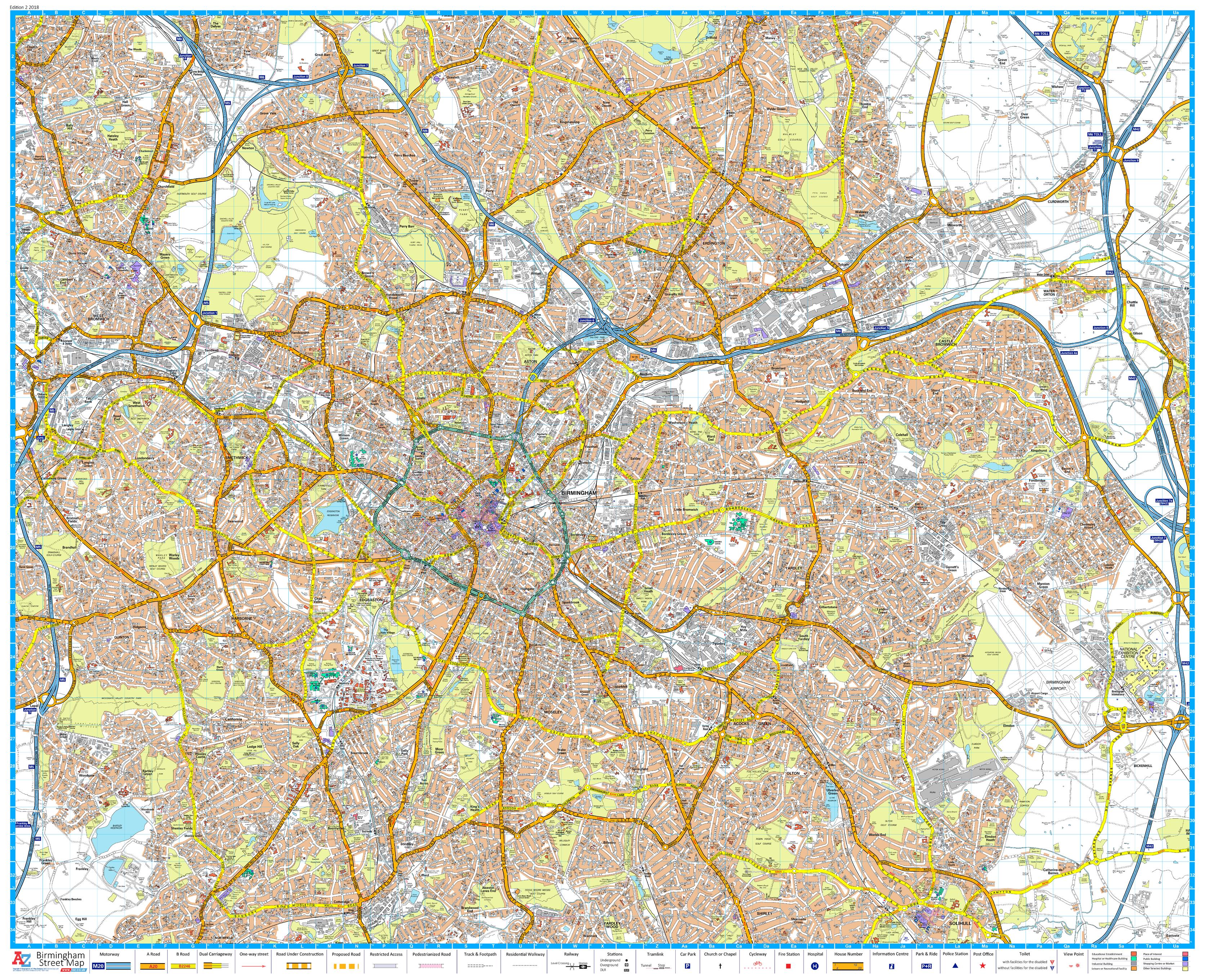
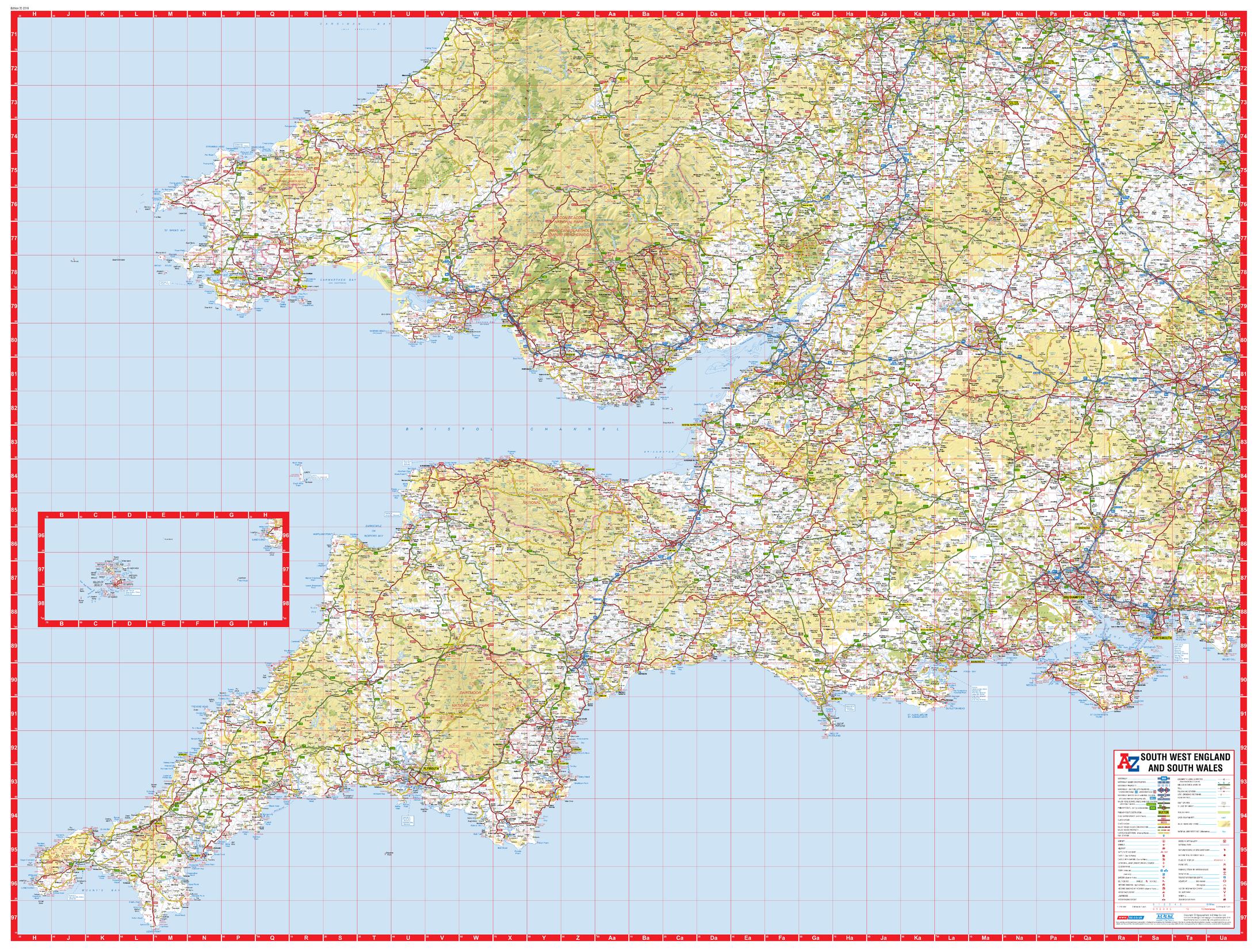
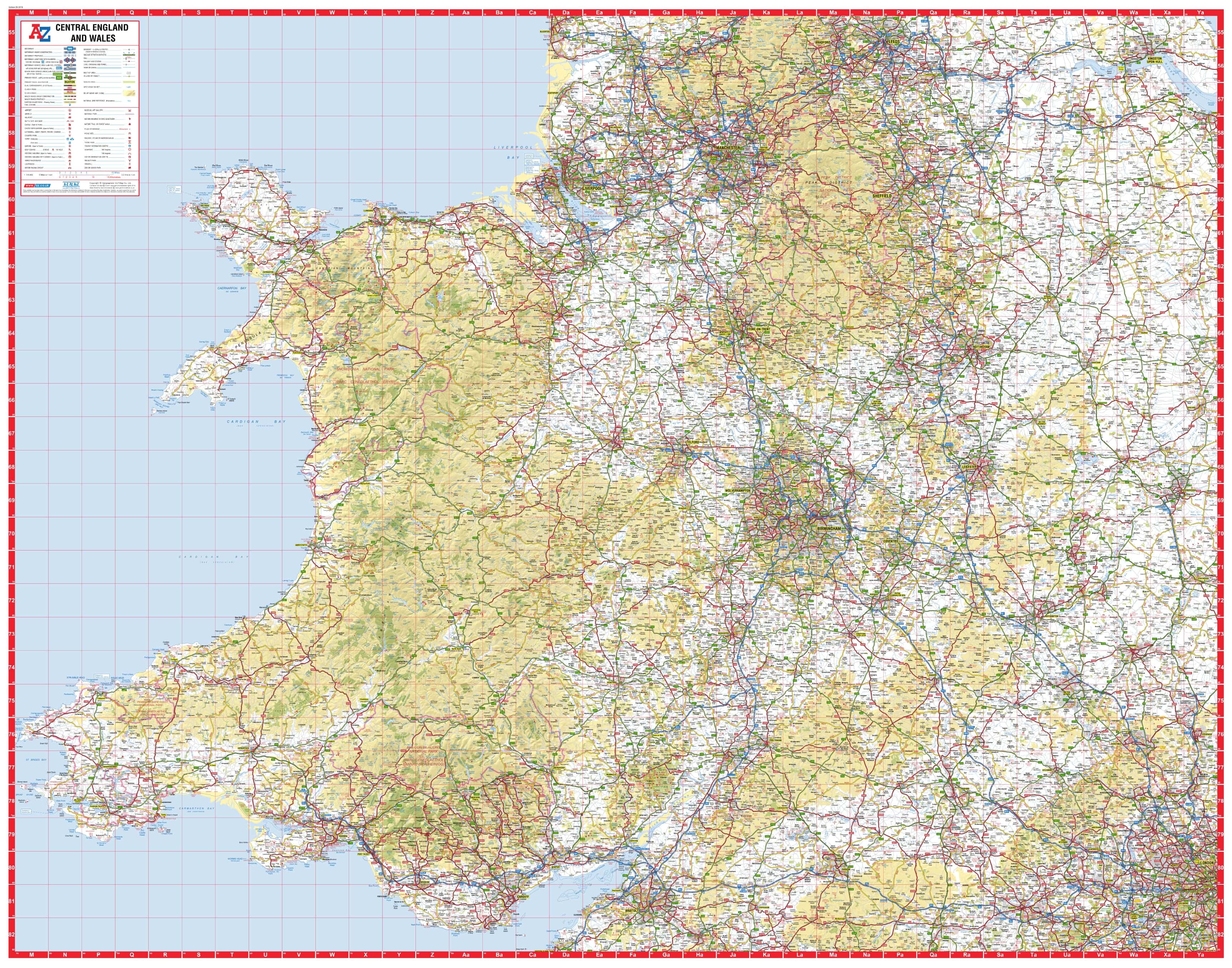
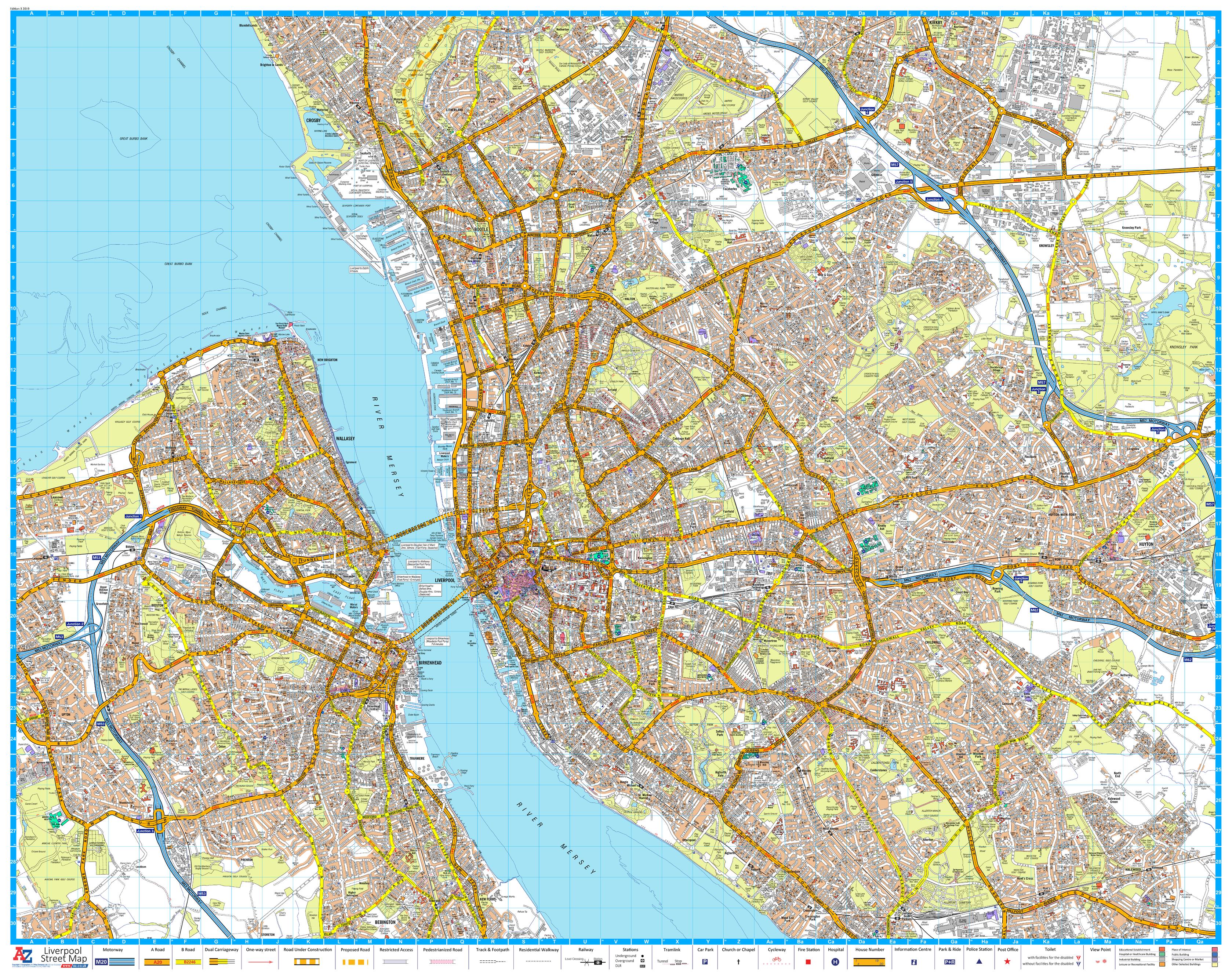
London Master Plan North East A-Z 1015 x 763mm Wall Map
Size: 1015 mm (W) x 763 mm (H)
Scale: 1:21,477
Published: 2019
Publisher: Geographers’ A-Z Map Company
🧭 Navigate North East London with Confidence and Clarity
Explore the ever-evolving neighbourhoods of North East London — from the creative energy of Hackney to the waterways of Walthamstow and beyond — with this authoritative Master Plan Wall Map by the Geographers’ A-Z Map Company.
Part of a 9-sheet series covering the entire Greater London area, this map delivers meticulous street-level detail, postcode district boundaries, and local authority borders, all in A-Z’s renowned, easy-to-read format. Whether used alone or combined with adjoining sheets, this map is an indispensable tool for professionals, educators, planners, and proud Londoners.
🔍 Map Features
| ✅ | Included on the Map |
|---|---|
| 🗺️ | Classic A-Z full street-level detail |
| 📮 | Clearly defined postcode districts and sectors |
| 🏛️ | Accurate local authority boundary lines |
| 🚉 | Transport networks, including rail, Underground, Overground, and DLR |
| 🌳 | Green spaces, rivers, canals, parks, and waterways |
| 🧩 | Seamless edges for joining with the rest of the 9-map Master Plan series |
📍 Coverage Includes:
-
Stratford
-
Hackney
-
Leyton
-
Walthamstow
-
Clapton
-
Stoke Newington
-
Wanstead
-
Tottenham
-
Homerton
-
Forest Gate
This map is ideal for local authorities, delivery and logistics teams, estate agents, planners, or anyone seeking a clear and reliable reference of North East London.
📐 Specifications
| Specification | Details |
|---|---|
| Scale | 1:21,477 |
| Dimensions | 1015 mm (W) x 763 mm (H) |
| Publisher | Geographers’ A-Z Map Company |
| Edition | 2019 |
| Map Series | 1 of 9 Master Plan sheets for London |
| Data Source | Ordnance Survey & A-Z cartography |
🖨️ Format Options
| 📄 Format | 📋 Description |
|---|---|
| Paper (160 gsm) | High-quality satin finish paper — suitable for pinning, mounting, or framing |
| Laminated | Fully encapsulated in 80-micron gloss laminate — durable, waterproof, and wipeable |
| Laminated with Hang Rails | Ready-to-hang with natural timber rails and hanging cord |
| Canvas (395 gsm) | Printed on HP Professional Matte Canvas — museum-quality texture, fade-resistant |
| Canvas with Hang Rails | Elegant wooden hang rails attached — ready to display in office or home |
🎯 Ideal For:
-
🏢 Business and office planning across boroughs
-
📦 Delivery route optimisation in postcode districts
-
🏫 Educational and classroom use
-
🏘️ Urban design, real estate, and planning
-
🖼️ Stylish wall décor with geographic substance
Join the full Master Plan series or let North East London stand alone in bold, professional detail.
A timeless and practical centrepiece for anyone with an eye on the city.
Original: $50.05
-65%$50.05
$17.52Product Information
Product Information
Shipping & Returns
Shipping & Returns
Description
Size: 1015 mm (W) x 763 mm (H)
Scale: 1:21,477
Published: 2019
Publisher: Geographers’ A-Z Map Company
🧭 Navigate North East London with Confidence and Clarity
Explore the ever-evolving neighbourhoods of North East London — from the creative energy of Hackney to the waterways of Walthamstow and beyond — with this authoritative Master Plan Wall Map by the Geographers’ A-Z Map Company.
Part of a 9-sheet series covering the entire Greater London area, this map delivers meticulous street-level detail, postcode district boundaries, and local authority borders, all in A-Z’s renowned, easy-to-read format. Whether used alone or combined with adjoining sheets, this map is an indispensable tool for professionals, educators, planners, and proud Londoners.
🔍 Map Features
| ✅ | Included on the Map |
|---|---|
| 🗺️ | Classic A-Z full street-level detail |
| 📮 | Clearly defined postcode districts and sectors |
| 🏛️ | Accurate local authority boundary lines |
| 🚉 | Transport networks, including rail, Underground, Overground, and DLR |
| 🌳 | Green spaces, rivers, canals, parks, and waterways |
| 🧩 | Seamless edges for joining with the rest of the 9-map Master Plan series |
📍 Coverage Includes:
-
Stratford
-
Hackney
-
Leyton
-
Walthamstow
-
Clapton
-
Stoke Newington
-
Wanstead
-
Tottenham
-
Homerton
-
Forest Gate
This map is ideal for local authorities, delivery and logistics teams, estate agents, planners, or anyone seeking a clear and reliable reference of North East London.
📐 Specifications
| Specification | Details |
|---|---|
| Scale | 1:21,477 |
| Dimensions | 1015 mm (W) x 763 mm (H) |
| Publisher | Geographers’ A-Z Map Company |
| Edition | 2019 |
| Map Series | 1 of 9 Master Plan sheets for London |
| Data Source | Ordnance Survey & A-Z cartography |
🖨️ Format Options
| 📄 Format | 📋 Description |
|---|---|
| Paper (160 gsm) | High-quality satin finish paper — suitable for pinning, mounting, or framing |
| Laminated | Fully encapsulated in 80-micron gloss laminate — durable, waterproof, and wipeable |
| Laminated with Hang Rails | Ready-to-hang with natural timber rails and hanging cord |
| Canvas (395 gsm) | Printed on HP Professional Matte Canvas — museum-quality texture, fade-resistant |
| Canvas with Hang Rails | Elegant wooden hang rails attached — ready to display in office or home |
🎯 Ideal For:
-
🏢 Business and office planning across boroughs
-
📦 Delivery route optimisation in postcode districts
-
🏫 Educational and classroom use
-
🏘️ Urban design, real estate, and planning
-
🖼️ Stylish wall décor with geographic substance
Join the full Master Plan series or let North East London stand alone in bold, professional detail.
A timeless and practical centrepiece for anyone with an eye on the city.